
Advanced Search for Maps
Showing 1-5 of 5
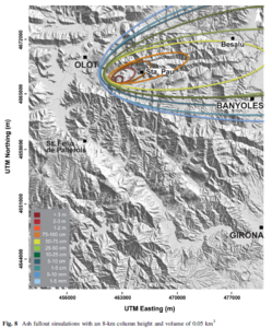
Figure in a journal article
Ash fallout simulations with an 8-km column height and volume of 0.05 km³
Figure 8 in: Bartolini, S., Bolós, X., Martí, J., Pedra, E. R., & Planagumà, L. (2015). Hazard assessment at the quaternary La Garrotxa volcanic field (NE Iberia). Natural Hazards, 78(2), 1349-1367. https://doi.org/10.1007/s11069-015-1774-y
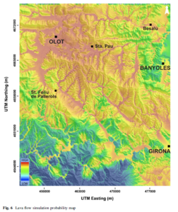
Figure in a journal article
Lava flow simulation probability map
Figure 6 in: Bartolini, S., Bolós, X., Martí, J., Pedra, E. R., & Planagumà, L. (2015). Hazard assessment at the quaternary La Garrotxa volcanic field (NE Iberia). Natural Hazards, 78(2), 1349-1367. https://doi.org/10.1007/s11069-015-1774-y
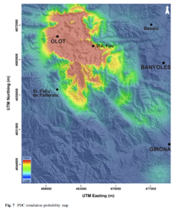
Figure in a journal article
PDC simulation probability map
Figure 7 in: Bartolini, S., Bolós, X., Martí, J., Pedra, E. R., & Planagumà, L. (2015). Hazard assessment at the quaternary La Garrotxa volcanic field (NE Iberia). Natural Hazards, 78(2), 1349-1367. https://doi.org/10.1007/s11069-015-1774-y
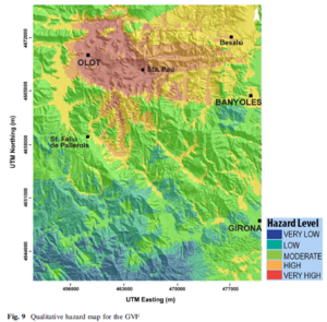
Figure in a journal article
Qualitative hazard map for the GVF
Figure 9 in: Bartolini, S., Bolós, X., Martí, J., Pedra, E. R., & Planagumà, L. (2015). Hazard assessment at the quaternary La Garrotxa volcanic field (NE Iberia). Natural Hazards, 78(2), 1349-1367. https://doi.org/10.1007/s11069-015-1774-y
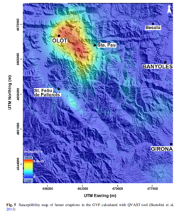
Figure in a journal article
Susceptibility map of future eruptions in the GVF calculated with QVAST tool
Figure 5 in: Bartolini, S., Bolós, X., Martí, J., Pedra, E. R., & Planagumà, L. (2015). Hazard assessment at the quaternary La Garrotxa volcanic field (NE Iberia). Natural Hazards, 78(2), 1349-1367. https://doi.org/10.1007/s11069-015-1774-y