Blog

Featured

Welcome to the website!

Welcome to the IAVCEI Commission on Volcanic Hazard & Risk Volcanic Hazard Maps website!

The purpose of the website is, primarily, to serve as a resource for hazard mappers (or other interested parties) to explore how common issues in hazard map development have been addressed at different volcanoes, in different countries, for different hazards, and for different intended audiences. We also strive to provide a look at how hazard maps have evolved through time, both globally and at specific volcanoes.

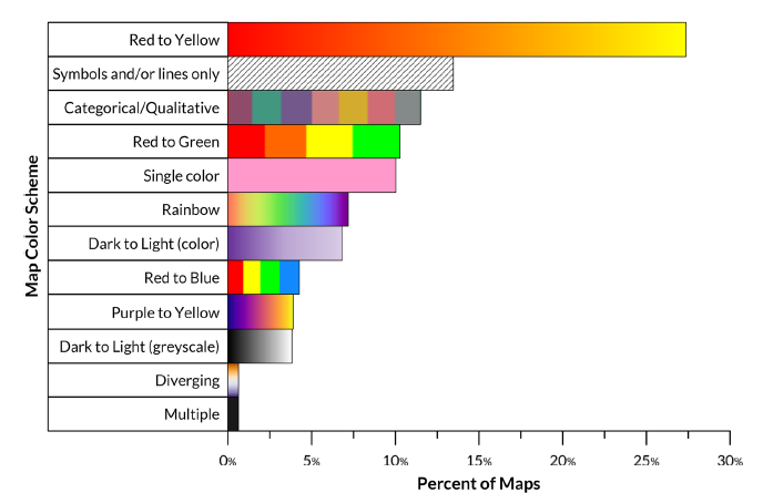
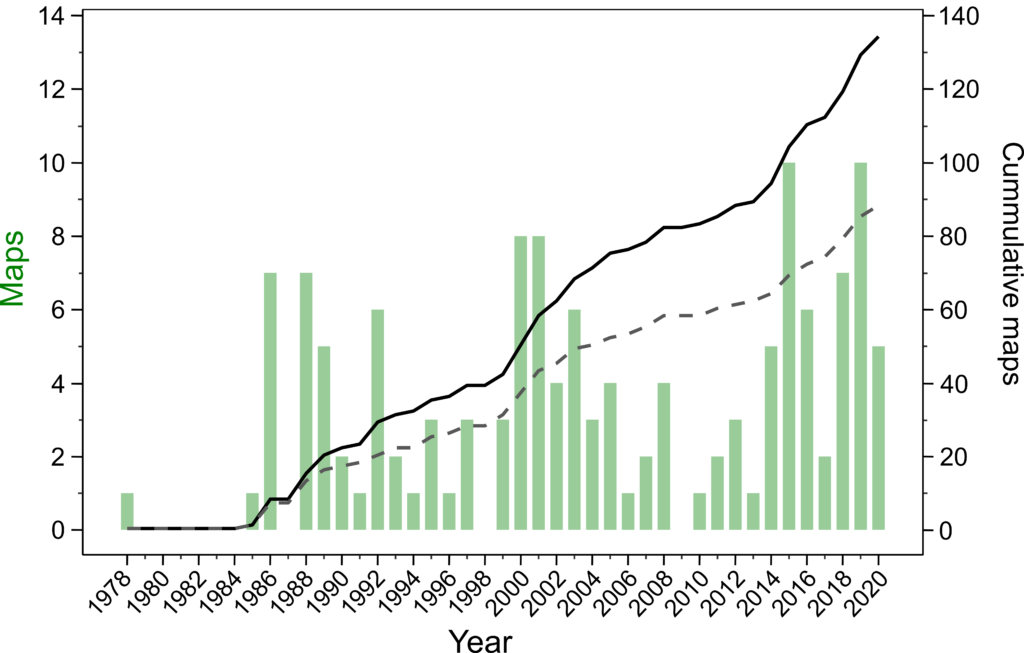
The IAVCEI CVHR Volcanic Hazard Map Database underlies this website and is a searchable global collection of volcanic hazard maps. Map classification metadata such as hazard types considered, hazard zone presentation, temporal and spatial scale, zonation methodology, and audience and purpose have been cataloged (see the Diversity of Maps pages) and can be used to search for particular maps of interest using our search and browse tools:

Basic Map Search

Advanced Map Search

Browse maps by Volcano

Browse maps by Country

Read more about how the database was created and who is involved in the project on the About the Database page.

This is version 1.0 of the website and database which was populated by examining each map in detail and recording map metadata. Sometimes, map data was not always readily apparent or the map was translated using a variety of tools. As such, we fully anticipate that there may be errors! We also know that we are missing important maps that we would love to include. To suggest corrections or add maps to the database, please contact us!

Paper of Interest: The Volcanic Hazard Maps Database: an initiative of the IAVCEI Commission on Volcanic Hazards and Risk

Our paper about the database and website is now published in Applied Volcanology! It’s open-source and available here.

In this work, we present the database and website, discuss the map classification scheme, explore the enormous diversity of hazard maps, and suggest ways that the database and website can be used by the community for education, outreach, and engagement with map users and stakeholders.

Figure 13 reproduced from Ogburn et al. 2023: Percent of maps in the database using different color-scheme types to differentiate volcanic hazard zones. Bar colors give examples of the
color-scheme in question. Note that most of these color schemes might be used as gradients or as discrete colored zones

Full paper citation:

Ogburn, S. E., Charlton, D., Norgaard, D., Wright, H. M., Calder, E. S., Lindsay, J., Ewert, J., Takarada, S. & Tajima, Y. (2023). The Volcanic Hazard Maps Database: an initiative of the IAVCEI Commission on Volcanic Hazards and Risk. Journal of Applied Volcanology, 12(1), 1-25. https://doi.org/10.1186/s13617-022-00128-9

IAVCEI 2023 session: The next generation of volcanic hazard and risk maps

Volcanic hazard maps are visual, spatial depictions of the areas that could be potentially impacted by volcanic phenomena. They can represent a common reference point for discussion and mitigation of volcanic risk when developed, communicated, and used appropriately, as they put all parties quite literally “on the same page” of hazard information. Although most volcanic hazard maps show similar types of content, such as hazard footprints, they vary greatly in input data, communication style, appearance, visual design and their purpose.

The IAVCEI Commission on Volcanic Hazard and Risk has a working group dedicated to hazard mapping and discussing how we can best use maps to communicate hazard in the future. This session welcomes research around the development, use and effectiveness of volcanic hazard and risk maps. We encourage submissions that address new and novel techniques and frameworks used to develop maps for long term hazard assessment and for use during volcanic crises, comparisons between versions of hazard maps at a single volcano, and experiences regarding how hazard maps are interpreted and used by diverse audiences during volcanic activity. We also welcome case studies where stakeholders have been engaged during the map making process, highlighting what worked and what did not, as well as examples of where event trees and expert elicitation have been used to inform hazard maps. The session aims to provide an overview of what hazard and risk maps could look like in the future, based on examples from around the world. 

IAVCEI 2023 workshop. State of the Volcanic Hazard Map 5: Hazard map database and source book workshop

The IAVCEI Commission on Volcanic Hazard and Risk has a working group dedicated to hazard mapping. The hazard mapping working group held its first workshop at COV8 (State of the Hazard Map 1), and the most recent at COV11 (State of the Hazard Map 4). We propose to host a meeting at the IAVCEI General Assembly in Rotorua. The workshop will continue the broad aims of the earlier meetings alongside some new initiatives, namely presenting and discussing a new hazard map database and stakeholder tool. The workshop will bring together people from around the world working on or with volcanic hazard maps, and will have three primary aims: 1) to openly discuss approaches and experiences regarding how hazard maps are interpreted and used by different groups; 2) to present and comment on a new online database of volcanic hazard maps and stakeholder tool; and 3) to discuss the new source book for volcanic hazard mapping. In line with previous working group events, a key philosophy of this workshop is that participants will be encouraged to bring their experience to the table for discussion, so that the workshop format will be more about exchange of knowledge rather than instruction about particular techniques. The workshop will take the form of short presentations followed by group discussions, and the day will be divided up based on the aims outlined above. 

1 day post-conference workshop, 4 February 2023

https://confer.eventsair.com/iavcei2023/workshop-details

Paper of interest: Volcano monitoring in Latin America: taking a step forward

The new special issue of the open-access journal Volcanica, Vol. 4, No. S1, Volcano Observatories in Latin America is available in both English and Spanish and is a collaborative effort of the Asociación Latinoamericana de Volcanología (ALVO; ALVO Oficial). The special issue contains many manuscripts of interest to the hazard mapping and hazard assessment community. Descriptions of monitoring and hazard assessment practices in each country can be found in the special issue.

Of particular note for the hazard mapping community is the preface to the special issue: “Volcano monitoring in Latin America: taking a step forward” by Forte et al. (2021), which gives an overview of Latin American volcano monitoring agencies and their activities, including a discussion of the development of Latin American hazard maps through time. Included with the paper is a supplementary dataset of 153 Latin American hazard map references from 1978-2021. This dataset was extremely useful for finding and adding Latin American maps to the Volcanic Hazard Maps Database.

Figure 3 reproduced from Forte et al. (2021): Published volcanic hazard maps for the Latin American volcanoes. The vertical bars show the number of hazard maps published per year. The solid black curve represents the cumulative number of hazard maps published, while the dashed line shows the cumulative number of published hazard maps, but excluding updates (i.e. number of volcanoes with hazard maps). For details about references used to build this figure, see the Supplementary Material (EN).

Full paper citation:

Forte, P., Rodríguez, L., Jácome Paz, M. P., Caballero García, L., Alpízar Segura, Y., Bustos, E., Perales Moya, C., Espinoza, E., Vallejo, S. and Agusto, M. (2021) “Volcano monitoring in Latin America: taking a step forward : Preface to Special Issue on Volcano Observatories in Latin America”, Volcanica, 4(S1), p. vii – xxxiii. doi: 10.30909/vol.04.S1.viixxxiii.