
Advanced Search for Maps
Showing 1-7 of 7
Official, Flyer, brochure, short fact-sheet, or handout
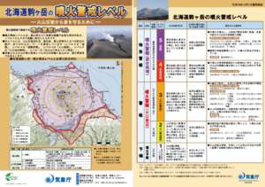
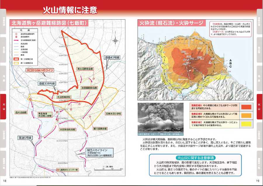
Hokkaido Komagatake Volcanic Alert Levels
Japan Meteorological Agency. (2016). Hokkaido Komagatake Volcanic Alert Levels. Volcano Monitoring and Warning Center, Volcano Division, Earthquake and Volcano Department.
Official, Map in a booklet, long fact-sheet, or handbook
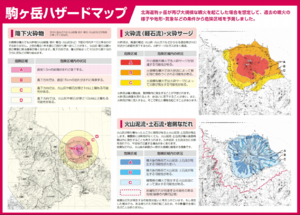
Komagatake Hazard Map
Nanae Town. Nanae Town Disaster Prevention Guide Map.
Official, Interactive web-based map
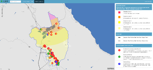
Nanae Town Eruption/Earthquake [Interactive Map]
Nanae Town. (2022). Nanae Town Eruption/Earthquake [Interactive Map]. http://www2.town.nanae.hokkaido.jp/bousai/hazardmap/map.html?lay=funka
Official, Map in a booklet, long fact-sheet, or handbook
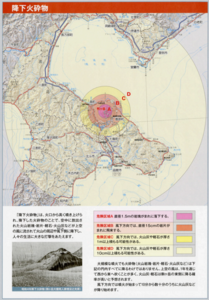
Volcanic eruption hazard area prediction map: Pyroclastic fall
Page 10 in: Volcano Disaster Management Councils of Mt.Komagatake. (2010). Volcanic disaster prevention handbook of Mt.Komagatake
Official, Map in a booklet, long fact-sheet, or handbook
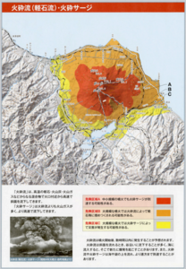
Volcanic eruption hazard area prediction map: Pyroclastic flow (pumice flow)/pyroclastic surge
Page 11 in: Volcano Disaster Management Councils of Mt. Komagatake. (2010). Volcanic disaster prevention handbook of Mt.Komagatake
Official, Map in a booklet, long fact-sheet, or handbook
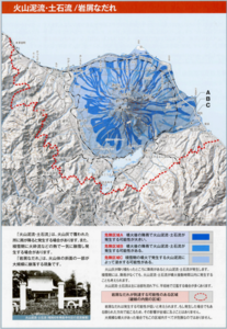
Volcanic eruption hazard area prediction map: Volcanic mudlfow, debris flow/debris avalanche
Page 12 in: Volcano Disaster Management Councils of Mt. Komagatake. (2010). Volcanic disaster prevention handbook of Mt.Komagatake
Official, Map in a booklet, long fact-sheet, or handbook
Volcano Information
Nanae Town. (2020). Disaster Prevention Hazard Map for Nanae Town. https://www.town.nanae.hokkaido.jp/hotnews/detail/00009274.html