Advanced Search for Maps
Showing 1-8 of 8
Tanaga, United States
Official, Figure in hazard assessment
Approximate areas likely to be affected by pyroclastic flows and surges originating at the active vents of the Tanaga volcanic cluster, Tanaga Island, Alaska
Figure 15 in: Coombs, M.L., McGimsey, R.G. & Browne, B.L. (2007). Preliminary volcano-hazard assessment for the Tanaga volcanic cluster, Tanaga Island, Alaska. U.S. Geological Survey, Scientific Investigations Report 2007-5094, 41 p., 1 plate. https://doi.org/10.3133/sir20075094
Tanaga Volcanic Cluster (Sajaka, Takawangha, & Tanaga), United States
Official, Figure in hazard assessment
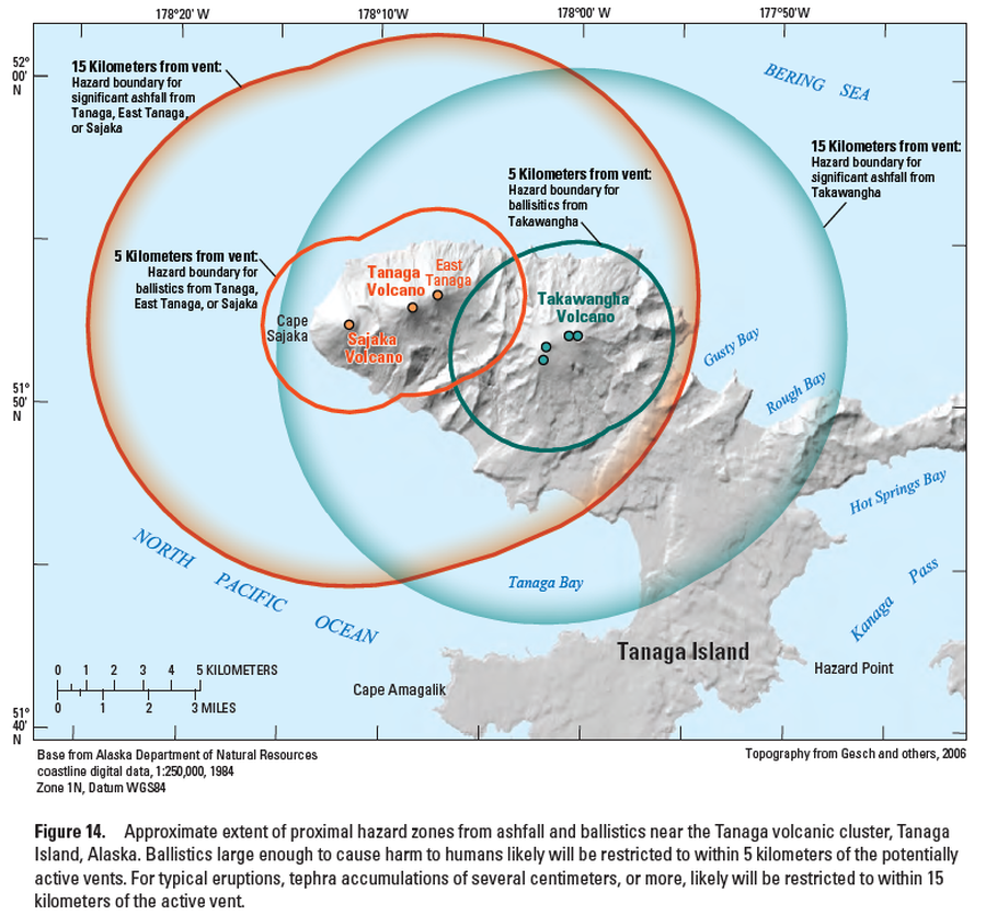
Approximate extent of proximal hazard zones from ashfall and ballistics near the Tanaga volcanic cluster, Tanaga Island, Alaska
Figure 14 in: Coombs, M.L., McGimsey, R.G. & Browne, B.L. (2007). Preliminary volcano-hazard assessment for the Tanaga volcanic cluster, Tanaga Island, Alaska. U.S. Geological Survey, Scientific Investigations Report 2007-5094, 41 p., 1 plate. https://doi.org/10.3133/sir20075094
Tanaga, United States
Official, Figure in hazard assessment
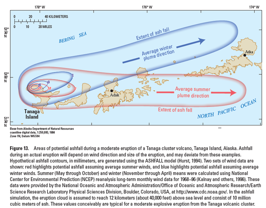
Areas of potential ashfall during a moderate eruption of a Tanaga cluster volcano, Tanaga Island, Alaska
Figure 13 in: Coombs, M.L., McGimsey, R.G. & Browne, B.L. (2007). Preliminary volcano-hazard assessment for the Tanaga volcanic cluster, Tanaga Island, Alaska. U.S. Geological Survey, Scientific Investigations Report 2007-5094, 41 p., 1 plate. https://doi.org/10.3133/sir20075094
Tanaga, United States
Official, Figure in hazard assessment
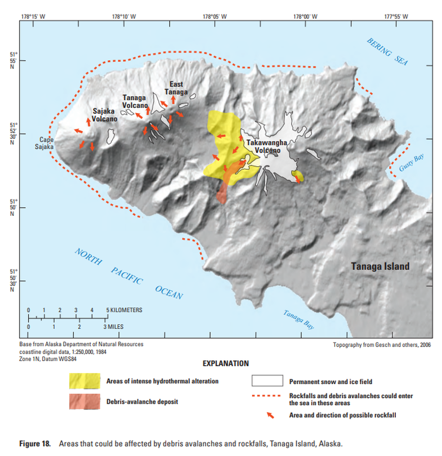
Areas that could be affected by debris avalanches and rockfalls, Tanaga Island, Alaska
Figure 18 in: Coombs, M.L., McGimsey, R.G. & Browne, B.L. (2007). Preliminary volcano-hazard assessment for the Tanaga volcanic cluster, Tanaga Island, Alaska. U.S. Geological Survey, Scientific Investigations Report 2007-5094, 41 p., 1 plate. https://doi.org/10.3133/sir20075094
Tanaga, United States
Official, Figure in hazard assessment
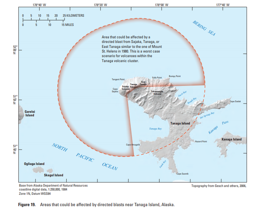
Areas that could be affected by directed blasts near Tanaga Island, Alaska
Figure 19 in: Coombs, M.L., McGimsey, R.G. & Browne, B.L. (2007). Preliminary volcano-hazard assessment for the Tanaga volcanic cluster, Tanaga Island, Alaska. U.S. Geological Survey, Scientific Investigations Report 2007-5094, 41 p., 1 plate. https://doi.org/10.3133/sir20075094
Tanaga, United States
Official, Figure in hazard assessment
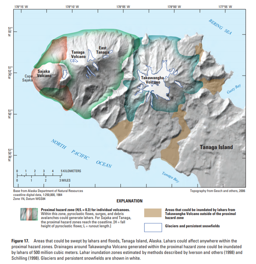
Areas that could be swept by lahars and floods, Tanaga Island, Alaska
Figure 17 in: Coombs, M.L., McGimsey, R.G. & Browne, B.L. (2007). Preliminary volcano-hazard assessment for the Tanaga volcanic cluster, Tanaga Island, Alaska. U.S. Geological Survey, Scientific Investigations Report 2007-5094, 41 p., 1 plate. https://doi.org/10.3133/sir20075094
Tanaga, United States
Official, Figure in hazard assessment
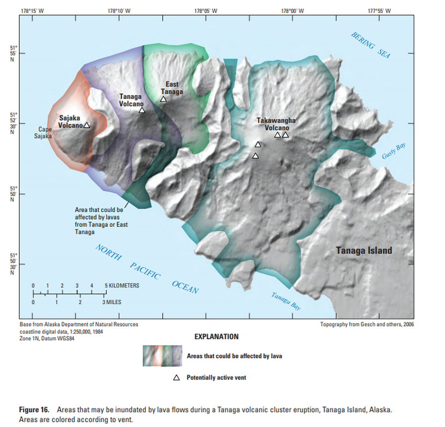
Areas that may be inundated by lava flows during a Tanaga volcanic cluster eruption, Tanaga Island, Alaska
Figure 16 in: Coombs, M.L., McGimsey, R.G. & Browne, B.L. (2007). Preliminary volcano-hazard assessment for the Tanaga volcanic cluster, Tanaga Island, Alaska. U.S. Geological Survey, Scientific Investigations Report 2007-5094, 41 p., 1 plate. https://doi.org/10.3133/sir20075094
Tanaga Volcanic Cluster (Sajaka, Takawangha, & Tanaga), United States
Official, Insert/poster-size map with accompanying report
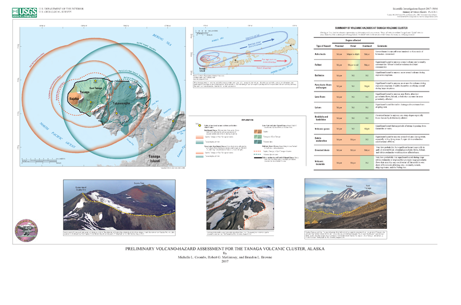
Preliminary Volcano-Hazard Assessment for the Tanaga Volcanic Cluster, Alaska
Plate 1 in: Coombs, M.L., McGimsey, R.G. & Browne, B.L. (2007). Preliminary volcano-hazard assessment for the Tanaga volcanic cluster, Tanaga Island, Alaska. U.S. Geological Survey, Scientific Investigations Report 2007-5094, 41 p., 1 plate. https://doi.org/10.3133/sir20075094