
Advanced Search for Maps
Showing 1-2 of 2
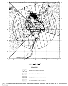
Figure in a journal article
Areas of potential hazards from lateral blasts, debris avalanche and debris flow, and tephra fall at Cerro Quemado, Guatemala.
Figure 7 in: Conway, F. M., Vallance, J. W., Rose, W. I., Johns, G. W., & Paniagua, S. (1992). Cerro Quemado, Guatemala: the volcanic history and hazards of an exogenous volcanic dome complex. Journal of Volcanology and Geothermal Research, 52(4), p. 303-323. https://doi.org/10.1016/0377-0273(92)90051-E
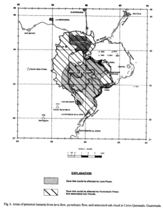
Figure in a journal article
Areas of potential hazards from lava flow, pyroclastic flow, and associated ash cloud at Cerro Quemado, Guatemala.
Figure 6 in: Conway, F. M., Vallance, J. W., Rose, W. I., Johns, G. W., & Paniagua, S. (1992). Cerro Quemado, Guatemala: the volcanic history and hazards of an exogenous volcanic dome complex. Journal of Volcanology and Geothermal Research, 52(4), p. 303-323. https://doi.org/10.1016/0377-0273(92)90051-E