Advanced Search for Maps
Showing 1-6 of 6
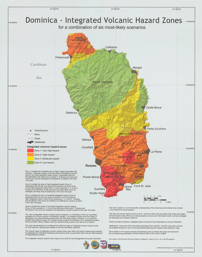
Official, Insert/poster-size map with accompanying report
Dominica - Integrated Volcanic Hazard Zones for a combination of six most-likely scenarios
Pocket insert in: Lindsay, J.M., Smith, A.L., Roobol, M.J., & Stasiuk, M.V. (2005). Dominica. Volcanic hazard atlas of the Lesser Antilles. In: Lindsay, J.M., Shepherd, J.B., Robertson, R.E.A., & Ali, S. (Eds) Volcanic hazard atlas of the Lesser Antilles. Seismic Research Unit, The University of the West Indies, Trinidad and Tobago, W.I. p. 2-47
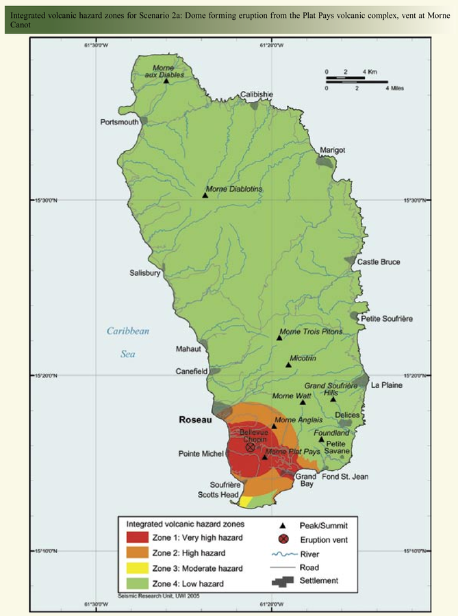
Official, Figure in hazard assessment
Integrated volcanic hazard zones for Scenario 2a: Dome forming eruption from the Plat Pays volcanic complex, vent at Morne Canot
Page 22 in: Lindsay, J.M., Smith, A.L., Roobol, M.J., & Stasiuk, M.V. (2005). Dominica. Volcanic hazard atlas of the Lesser Antilles. In: Lindsay, J.M., Shepherd, J.B., Robertson, R.E.A., & Ali, S. (Eds) Volcanic hazard atlas of the Lesser Antilles. Seismic Research Unit, The University of the West Indies, Trinidad and Tobago, W.I. p. 2-47
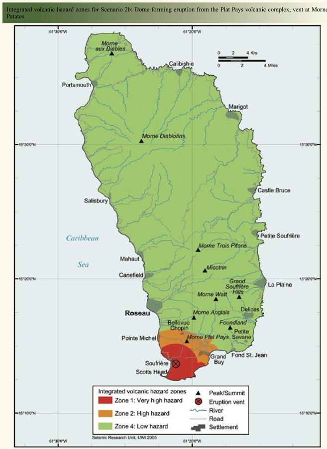
Official, Figure in hazard assessment
Integrated volcanic hazard zones for Scenario 2b: Dome forming eruption from the Plat Pays volcanic complex, vent at Morne Patates
Page 25 in: Lindsay, J.M., Smith, A.L., Roobol, M.J., & Stasiuk, M.V. (2005). Dominica. Volcanic hazard atlas of the Lesser Antilles. In: Lindsay, J.M., Shepherd, J.B., Robertson, R.E.A., & Ali, S. (Eds) Volcanic hazard atlas of the Lesser Antilles. Seismic Research Unit, The University of the West Indies, Trinidad and Tobago, W.I. p. 2-47
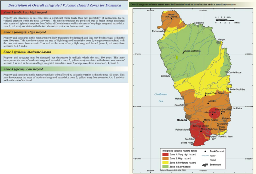
Official, Figure in hazard assessment
Overall Integrated volcanic hazard zones for Dominica based on a combination of the 6 most-likely scenarios
Page 43 in: Lindsay, J.M., Smith, A.L., Roobol, M.J., & Stasiuk, M.V. (2005). Dominica. Volcanic hazard atlas of the Lesser Antilles. In: Lindsay, J.M., Shepherd, J.B., Robertson, R.E.A., & Ali, S. (Eds) Volcanic hazard atlas of the Lesser Antilles. Seismic Research Unit, The University of the West Indies, Trinidad and Tobago, W.I.
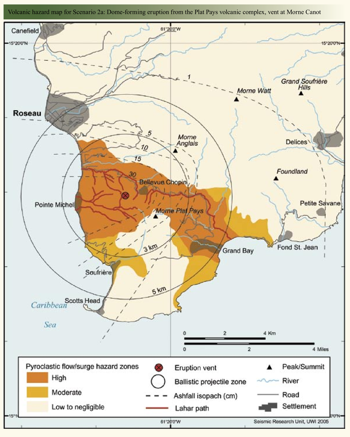
Official, Figure in hazard assessment
Volcanic hazard map for Scenario 2a: Dome-forming eruptions from the Plat Pays volcanic complex, vent at Morne Canot
Page 21 in: Lindsay, J.M., Smith, A.L., Roobol, M.J., & Stasiuk, M.V. (2005). Dominica. Volcanic hazard atlas of the Lesser Antilles. In: Lindsay, J.M., Shepherd, J.B., Robertson, R.E.A., & Ali, S. (Eds) Volcanic hazard atlas of the Lesser Antilles. Seismic Research Unit, The University of the West Indies, Trinidad and Tobago, W.I. p. 2-47
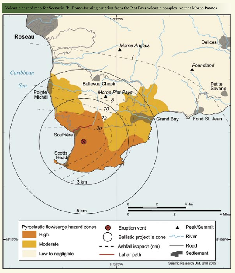
Official, Figure in hazard assessment
Volcanic hazard map for Scenario 2b: Dome-forming eruption from the Plat Pays volcanic complex, vent at Morne Patates
Page 24 in: Lindsay, J.M., Smith, A.L., Roobol, M.J., & Stasiuk, M.V. (2005). Dominica. Volcanic hazard atlas of the Lesser Antilles. In: Lindsay, J.M., Shepherd, J.B., Robertson, R.E.A., & Ali, S. (Eds) Volcanic hazard atlas of the Lesser Antilles. Seismic Research Unit, The University of the West Indies, Trinidad and Tobago, W.I. p. 2-47
