Advanced Search for Maps
Showing 1-10 of 12
Soufrière St. Vincent, Saint Vincent and the Grenadines
Official, Figure on website
Chateaubelair & Fitz Hughes Community Multi-Hazard Map
The University of the West Indies Seismic Research Centre (UWI-SRC) and National Emergency Management Organization (NEMO). (2021). Chateaubelair & Fitz Hughes Community Multi-Hazard Map. https://uwiseismic.com/wp-content/uploads/2021/10/Chateau-fitzhughes_Hazard-Map-scaled.jpg
Soufrière St. Vincent, Saint Vincent and the Grenadines
Official, Figure on website
Fancy Community Multi-Hazard Map
The University of the West Indies Seismic Research Centre (UWI-SRC) and National Emergency Management Organization (NEMO). (2021). Fancy Community Multi-Hazard Map. https://uwiseismic.com/wp-content/uploads/2021/10/Fancy-Hazard-Map-scaled.jpg
Soufrière St. Vincent, Saint Vincent and the Grenadines
Official, Figure on website
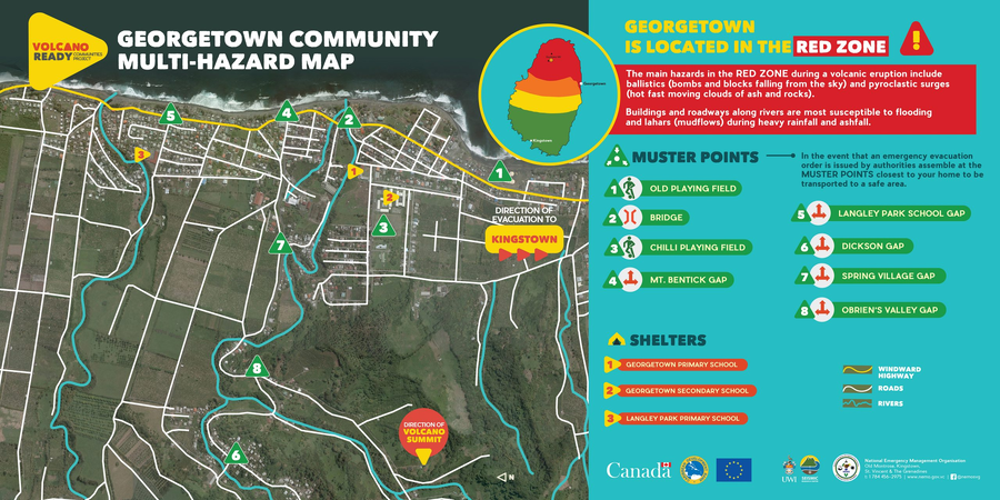
Georgetown Community Multi-Hazard Map
The University of the West Indies Seismic Research Centre (UWI-SRC) and National Emergency Management Organization (NEMO). (2021). Georgetown Community Multi-Hazard Map. https://uwiseismic.com/wp-content/uploads/2021/10/Georgetown-Hazard-Map-scaled.jpg
Soufrière St. Vincent, Saint Vincent and the Grenadines
Official, Figure in hazard assessment
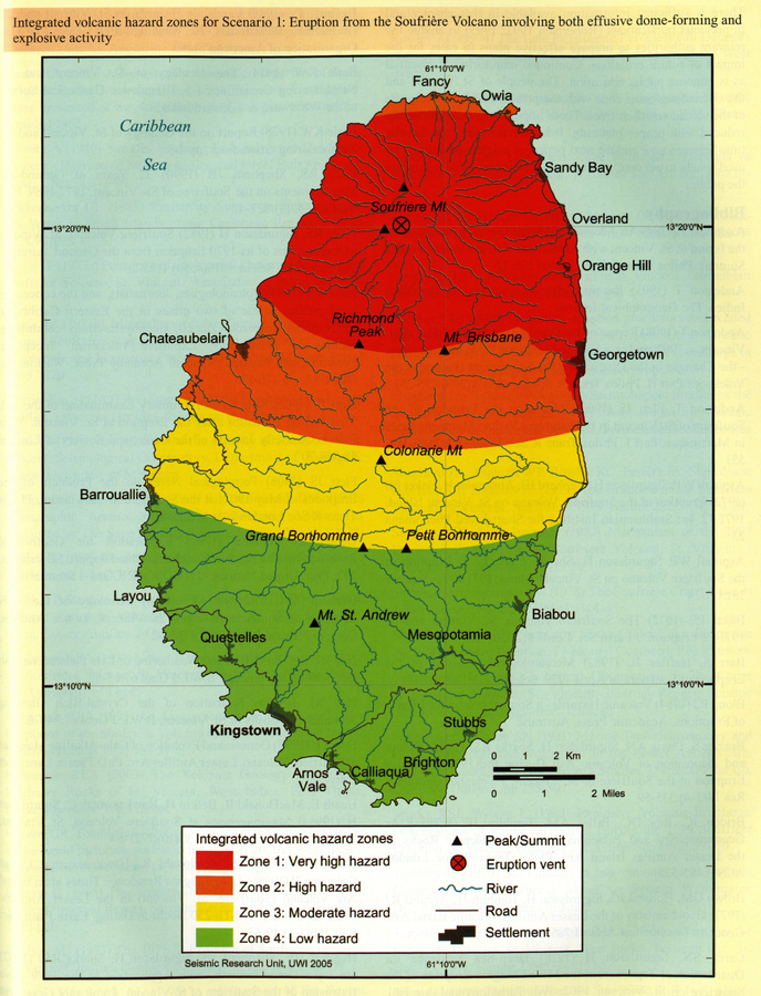
Integrated volcanic hazard zones for Scenario 1: Eruption from the Soufrière Volcano involving both effusive dome-forming and explosive activity
Page 258 in: Robertson, R. (2005). St. Vincent. In: Lindsay, J.M., Shepherd, J.B., Robertson, R.E.A., & Ali, S. (Eds) Volcanic hazard atlas of the Lesser Antilles. Seismic Research Unit, The University of the West Indies, Trinidad and Tobago, W.I., p. 241-261
Soufrière St. Vincent, Saint Vincent and the Grenadines
Official, Figure on website
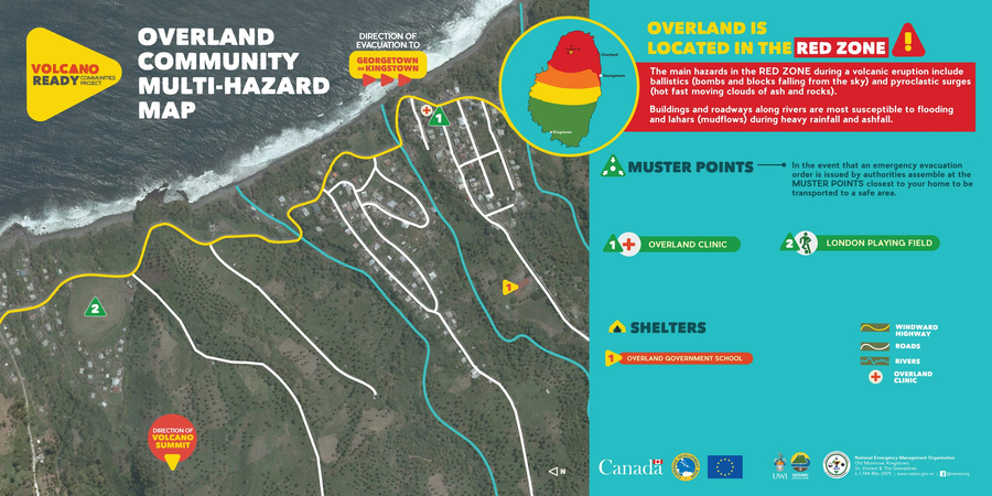
Overland Community Multi-Hazard Map
The University of the West Indies Seismic Research Centre (UWI-SRC) and National Emergency Management Organization (NEMO). (2021). Overland Community Multi-Hazard Map. https://uwiseismic.com/wp-content/uploads/2021/10/Overland-Hazard-Map-scaled.jpg
Soufrière St. Vincent, Saint Vincent and the Grenadines
Official, Figure on website
Owia/Point Community Multi-Hazard Map
The University of the West Indies Seismic Research Centre (UWI-SRC) and National Emergency Management Organization (NEMO). (2021). Owia/Point Community Multi-Hazard Map. https://uwiseismic.com/wp-content/uploads/2021/10/Owia-Point-Hazard-Map-scaled.jpg
Soufrière St. Vincent, Saint Vincent and the Grenadines
Official, Figure on website
Rose Hall Community Multi-Hazard Map
The University of the West Indies Seismic Research Centre (UWI-SRC) and National Emergency Management Organization (NEMO). (2021). Rose Hall Community Multi-Hazard Map. https://uwiseismic.com/wp-content/uploads/2021/10/Rose-Hall_Hazard-Map-scaled.jpg
Soufrière St. Vincent, Saint Vincent and the Grenadines
Official, Figure on website
Sandy Bay Community Multi-Hazard Map
The University of the West Indies Seismic Research Centre (UWI-SRC) and National Emergency Management Organization (NEMO). (2021). Sandy Bay Community Multi-Hazard Map. https://uwiseismic.com/wp-content/uploads/2021/10/Sandy-Bay_Hazard-Map-scaled.jpg
Soufrière St. Vincent, Saint Vincent and the Grenadines
Official, Figure on website
Spring Village Community Multi-Hazard Map
The University of the West Indies Seismic Research Centre (UWI-SRC) and National Emergency Management Organization (NEMO). (2021). Spring Village Community Multi-Hazard Map. https://uwiseismic.com/wp-content/uploads/2021/10/Spring-Village-Hazard-Map-scaled.jpg
Soufrière St. Vincent, Saint Vincent and the Grenadines
Official, Insert/poster-size map with accompanying report
St. Vincent - Integrated volcanic hazard zones for an eruption from La Soufrière Volcano involving both dome-forming and explosive activity
Pocket insert in: Robertson, R. (2005). St. Vincent. In: Lindsay, J.M., Shepherd, J.B., Robertson, R.E.A., & Ali, S. (Eds) Volcanic hazard atlas of the Lesser Antilles. Seismic Research Unit, The University of the West Indies, Trinidad and Tobago, W.I., p. 241-261
Page: 1 2