
Advanced Search for Maps
Showing 1-7 of 7
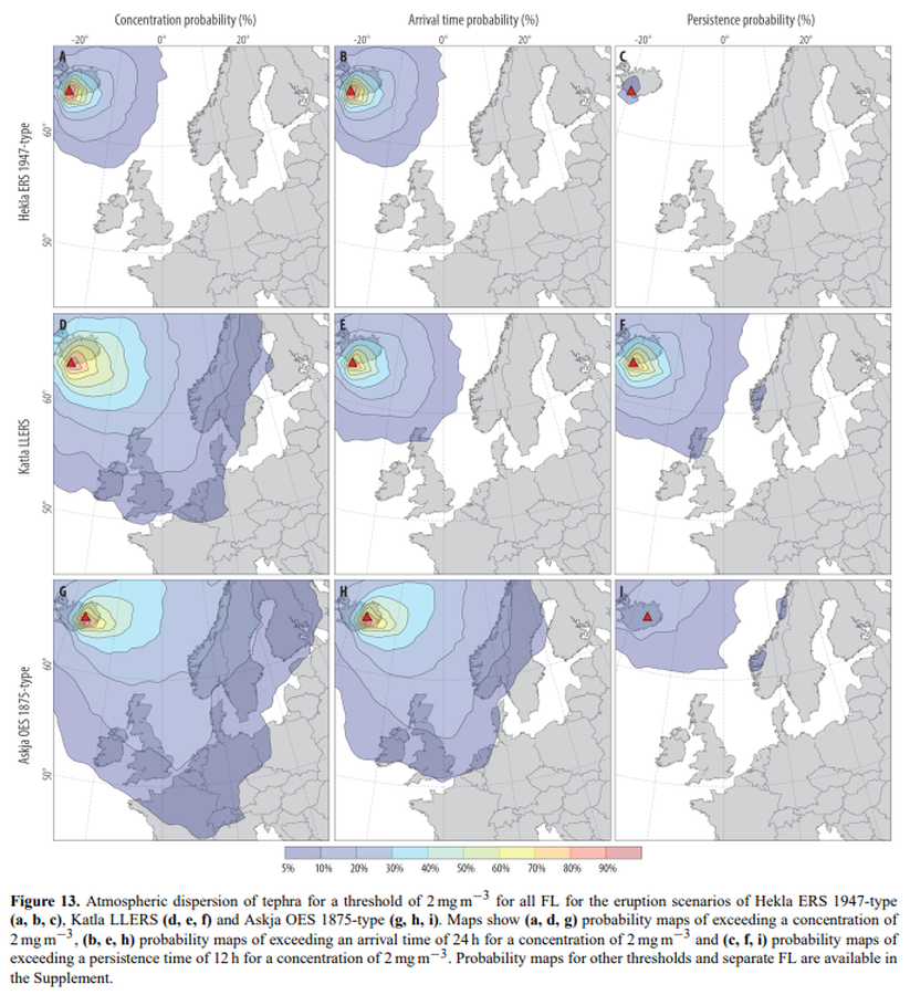
Figure in a journal article
Atmospheric dispersion of tephra for a threshold of 2 mg m−3 for all FL for the eruption scenarios of Hekla ERS 1947-type (a, b, c), Katla LLERS (d, e, f) and Askja OES 1875-type (g, h, i)
Figure 13 in: Biass, S., Scaini, C., Bonadonna, C., Folch, A., Smith, K., & Höskuldsson, A. (2014). A multi-scale risk assessment for tephra fallout and airborne concentration from multiple Icelandic volcanoes–Part 1: Hazard assessment. Natural hazards and earth system sciences, 14(8), 2265-2287. https://doi.org/10.5194/nhess-14-2265-2014
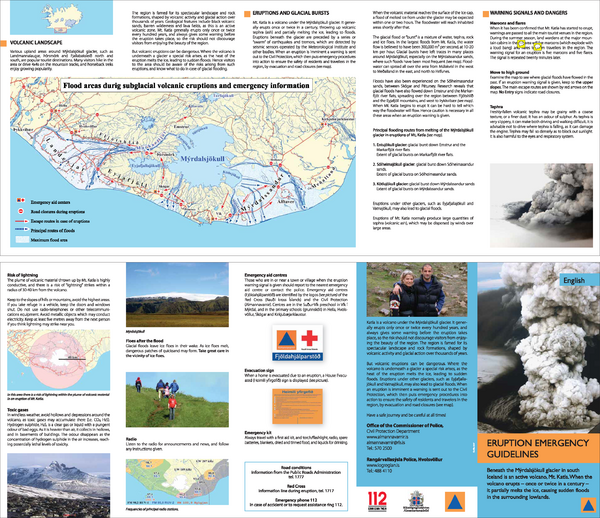
Official, Flyer, brochure, short fact-sheet, or handout
Eruption emergency guidelines – Katla in Mýrdalsjökull: English
Almannavarnir. (2017). Eruption emergency guidelines - Katla in Mýrdalsjökull.
Figure in a journal article
Expected impacts of tephra dispersal on European airspace sectors
Figure 11 in: Scaini, C., Biass, S., Galderisi, A., Bonadonna, C., Folch, A., Smith, K., & Höskuldsson, A. (2014). A multi-scale risk assessment for tephra fallout and airborne concentration from multiple Icelandic volcanoes–Part 2: Vulnerability and impact. Natural hazards and earth system sciences, 14(8), 2289–2312. https://doi.org/10.5194/nhess-14-2289-2014
Official, Sign or billboard
Katla – Mýrdalsjökull
Almannavarnir. (2017). Katla – Mýrdalsjökull.
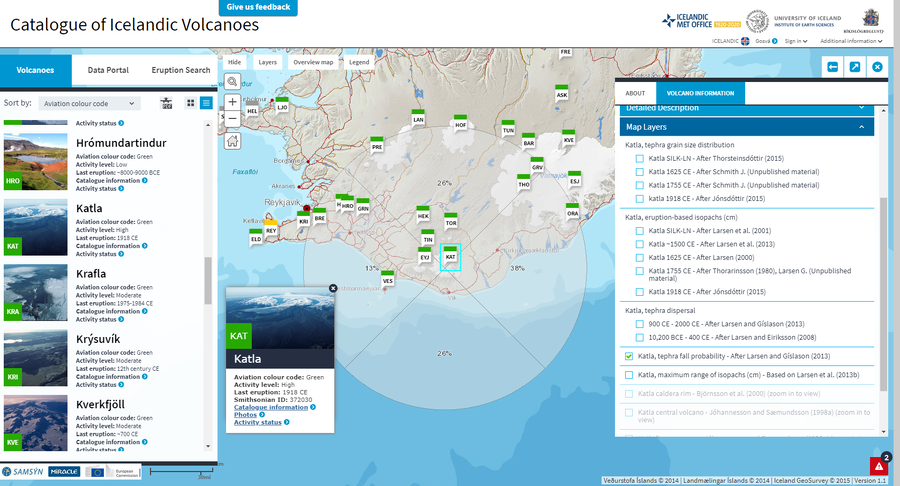
Official, Interactive web-based map
Katla, tephra fall probability - After Larsen and Gíslason (2013)
Larsen, G. & Guðmundsson, M.T. (2019). Katla. In: Oladottir, B., Larsen, G. & Guðmundsson, M. T. Catalogue of Icelandic Volcanoes. Iceland Meteorological Office (IMO), Univeristy of Iceland, and Civil Protection Department of the National Commissioner of the Iceland Police (CPD-NCIP). (Simplified from: Larsen and Gíslason 2013)
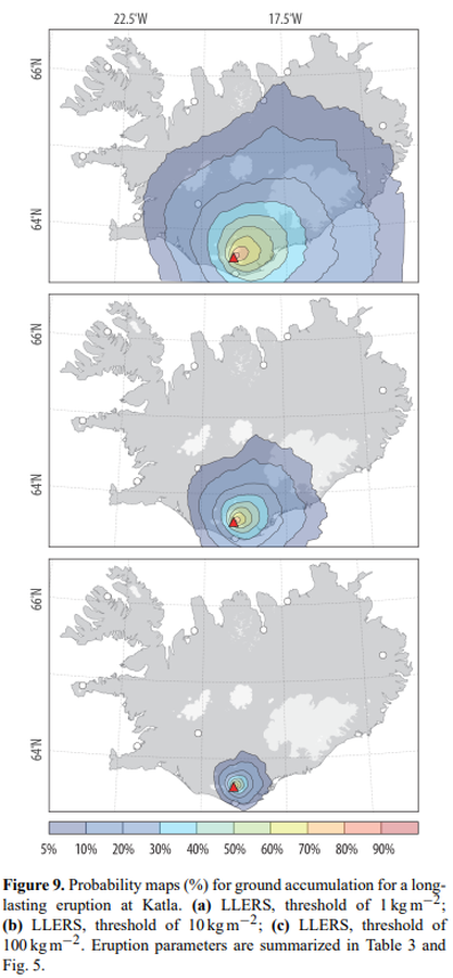
Figure in a journal article
Probability maps (%) for ground accumulation for a longlasting eruption at Katla
Figure 9 in: Biass, S., Scaini, C., Bonadonna, C., Folch, A., Smith, K., & Höskuldsson, A. (2014). A multi-scale risk assessment for tephra fallout and airborne concentration from multiple Icelandic volcanoes–Part 1: Hazard assessment. Natural hazards and earth system sciences, 14(8), 2265-2287. https://doi.org/10.5194/nhess-14-2265-2014
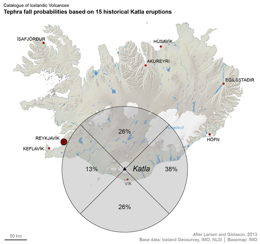
Official, Figure on website
Tephra fall probabilities based on 15 historical Katla eruptions
Larsen, G. & Guðmundsson, M.T. (2019). Katla. In: Oladottir, B., Larsen, G. & Guðmundsson, M. T. Catalogue of Icelandic Volcanoes. Iceland Meteorological Office (IMO), Univeristy of Iceland, and Civil Protection Department of the National Commissioner of the Iceland Police (CPD-NCIP). https://icelandicvolcanos.is//index.html (Simplified from: Larsen & Gíslason 2013)