
Advanced Search for Maps
Showing 1-8 of 8

Figure in a journal article
Ash fallout simulations (thickness) with a 5-km column height and volume of 0.3 km³
Figure 10 in: Bartolini, S., Geyer, A., Martí, J., Pedrazzi, D., & Aguirre-Díaz, G. (2014). Volcanic hazard on Deception Island (South Shetland Islands, Antarctica). Journal of Volcanology and Geothermal Research, 285, p. 150-168. https://doi.org/10.1016/j.jvolgeores.2014.08.009
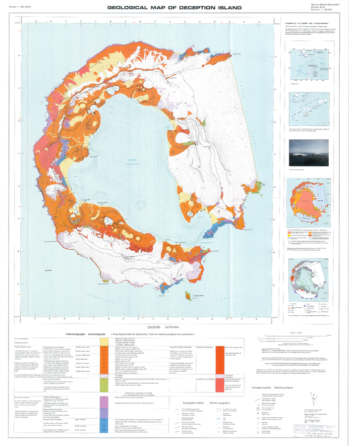
Official, Insert/poster-size map with accompanying report
Geologic Map of Deception Island
Sheet 6-A in: Smellie, J.L., López-Martínez, J., Headland, R.K., Hernández-Cifuentes, F., Maestro, A., Millar, I.L., Rey, J., Serrano, E., Somoza, L., & Thomson, J.W. (2002). Geology and geomorphology of Deception Island. Cambridge, British Antarctic Survey, 77 p. (BAS Geomap Series, Sheets 6A and 6B).
Figure in a journal article
Hazard map presented by Roobol (1982)
Figure 5 (in reprint) in: Roobol, M.J. (1982). The volcanic hazard at Deception Island, South Shetland Islands. British Antarctic Survey. 51, 237-245. (Reprinted in: Bartolini, S., Geyer, A., Martí, J., Pedrazzi, D., & Aguirre-Díaz, G. (2014). Volcanic hazard on Deception Island (South Shetland Islands, Antarctica). Journal of Volcanology and Geothermal Research, 285, p. 150-168. https://doi.org/10.1016/j.jvolgeores.2014.08.009)
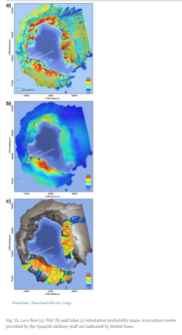
Figure in a journal article
Lava flow, PDC and lahar simulation probability maps.
Figure 11 in: Bartolini, S., Geyer, A., Martí, J., Pedrazzi, D., & Aguirre-Díaz, G. (2014). Volcanic hazard on Deception Island (South Shetland Islands, Antarctica). Journal of Volcanology and Geothermal Research, 285, p. 150-168. https://doi.org/10.1016/j.jvolgeores.2014.08.009
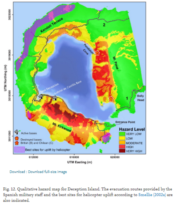
Figure in a journal article
Qualitative hazard map for Deception Island.
Figure 12 in: Bartolini, S., Geyer, A., Martí, J., Pedrazzi, D., & Aguirre-Díaz, G. (2014). Volcanic hazard on Deception Island (South Shetland Islands, Antarctica). Journal of Volcanology and Geothermal Research, 285, p. 150-168. https://doi.org/10.1016/j.jvolgeores.2014.08.009
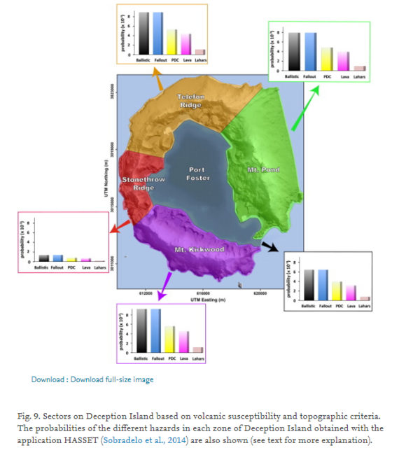
Figure in a journal article
Sectors on Deception Island based on volcanic susceptibility and topographic criteria.
Figure 9 in: Bartolini, S., Geyer, A., Martí, J., Pedrazzi, D., & Aguirre-Díaz, G. (2014). Volcanic hazard on Deception Island (South Shetland Islands, Antarctica). Journal of Volcanology and Geothermal Research, 285, p. 150-168. https://doi.org/10.1016/j.jvolgeores.2014.08.009
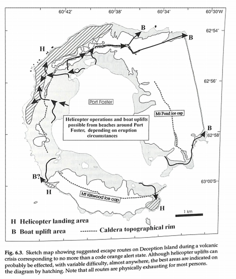
Official, Figure in hazard assessment
Sketch map showing suggested escape routes on Deception Island during a volcanic crisis corresponding to no more than a code orange alert state
Figure 6.3 in: Smellie, J.L., López-Martínez, J., Headland, R.K., Hernández-Cifuentes, F., Maestro, A., Millar, I.L., Rey, J., Serrano, E., Somoza, L., & Thomson, J.W. (2002). Geology and geomorphology of Deception Island. Cambridge, British Antarctic Survey, 77 p. (BAS Geomap Series, Sheets 6A and 6B).
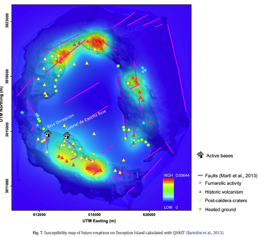
Figure in a journal article
Susceptibility map of future eruptions on Deception Island calculated with QVAST
Figure 7 in: Bartolini, S., Geyer, A., Martí, J., Pedrazzi, D., & Aguirre-Díaz, G. (2014). Volcanic hazard on Deception Island (South Shetland Islands, Antarctica). Journal of Volcanology and Geothermal Research, 285, p. 150-168. https://doi.org/10.1016/j.jvolgeores.2014.08.009