
Advanced Search for Maps
Showing 461-470 of 726
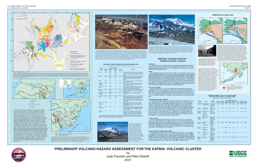
Official, Insert/poster-size map with accompanying report
Preliminary Volcano-Hazard Assessment for the Katmai Volcanic Cluster
Plate 1 in: Fierstein, J. & Hildreth, W. (2001). Preliminary volcano-hazard assessment for the Katmai Volcanic Cluster, Alaska. U.S. Geological Survey Open-File Report 00-489, 50 p., 1 plate. https://doi.org/10.3133/ofr00489
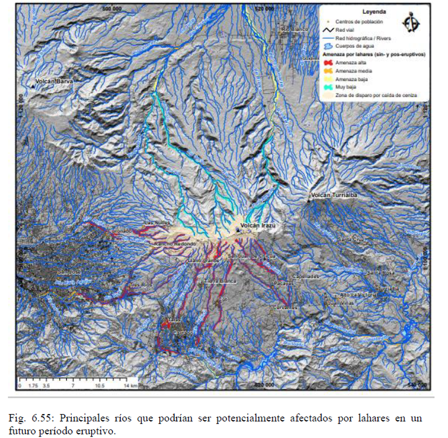
Official, Figure in hazard assessment
Principales ríos que podrían ser potencialmente afectados por lahares en un futuro período eruptivo
(Main rivers that could potentially be affected by lahars in a future eruptive period)
Figure 6.55 in: Alvarado, G.E., Campos-Durán, D., Brenes-André, J., Alpízar, Y., Núñez, S., Esquivel, L., Sibaja, J.P. & Fallas, B. (2021). Peligro Volcánico del Irazú, Costa Rica. Comisión Nacional de Prevención de Riesgos y Atención de Emergencias (CNE). Deciembre 2021.
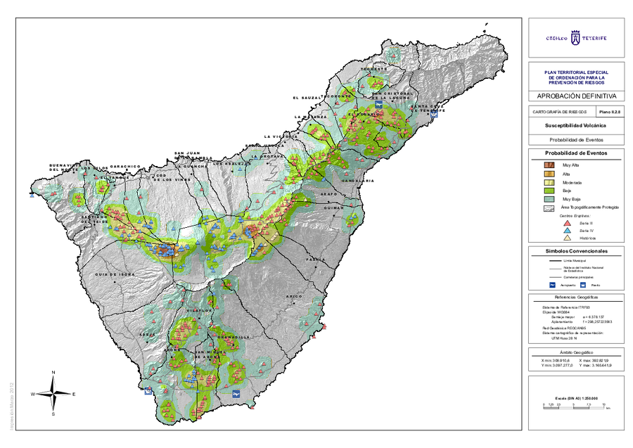
Official, Insert/poster-size map with accompanying report
Probabilidad de Eventos
(Event Probability)
Map II.2.8 in: Cabildo Tenerife. (2012). Plan Territorial Especial de Ordenación para la Prevención de Riesgos. Documento Cartográfico (Planos de Información).
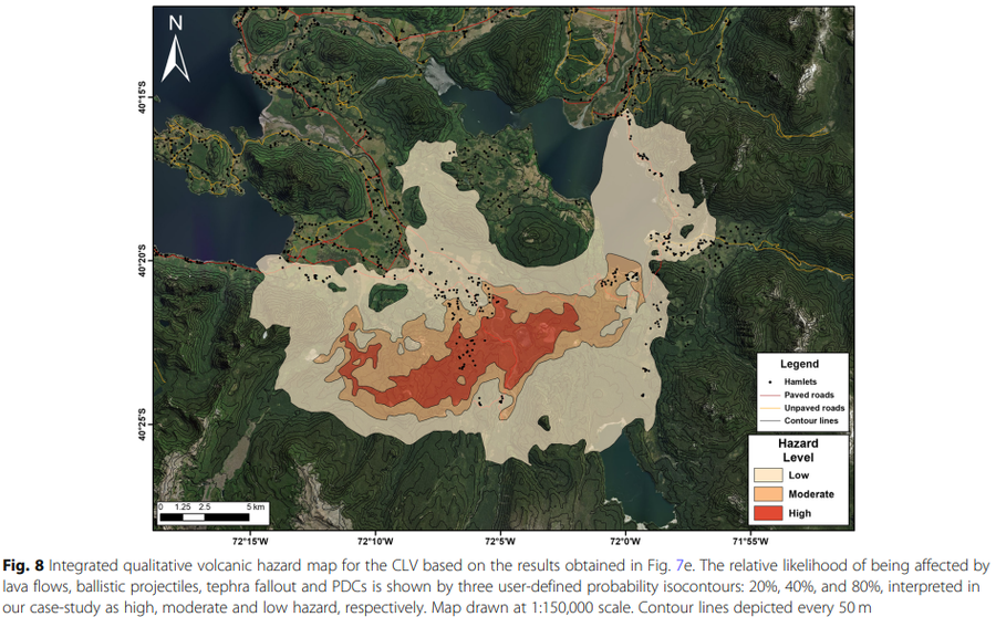
Figure in a journal article
Probabilistic volcanic hazard maps for the CLV
Figure 8 in: Bertin, D., Lindsay, J. M., Becerril, L., Cronin, S. J., & Bertin, L. J. (2019). MatHaz: a Matlab code to assist with probabilistic spatio-temporal volcanic hazard assessment in distributed volcanic fields. Journal of Applied Volcanology, 8(1), 1-25. https://doi.org/10.1186/s13617-019-0084-6

Figure in a journal article
Provisional volcanic hazard map for a large explosive eruption similar to the 1680 event
Figure 5 in: Komorowski JC., Morin J., Jenkins S., & Kelman I. (2016) Challenges of Volcanic Crises on Small Islands States. In: Fearnley C.J., Bird D.K., Haynes K., McGuire W.J., Jolly G. (eds) Observing the Volcano World. Advances in Volcanology. International Association of Volcanology and Chemistry of the Earth’s Interior – IAVCEI. Springer. https://doi.org/10.1007/11157_2015_15. Adapted from: Day, S.F., Faria, B.V.E. (2009). A geological hazard map of the Island of Fogo showing broad distribution of volcanic and other hazards. MIA-VITA Workshop, São Filipe, Fogo.
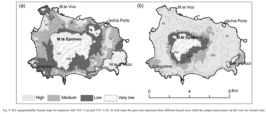
Figure in a journal article
PyF equiprobability hazard maps for eruptions with VEI = 3 and VEI = 4
Figure 9 in: Alberico, I., Lirer, L., Petrosino, P., & Scandone, R. (2008). Volcanic hazard and risk assessment from pyroclastic flows at Ischia island (southern Italy). Journal of volcanology and geothermal research, 171(1-2), 118-136.

Figure in a journal article
PyF risk map for VEI = 3 and VEI = 4
Figure 13 in: Alberico, I., Lirer, L., Petrosino, P., & Scandone, R. (2008). Volcanic hazard and risk assessment from pyroclastic flows at Ischia island (southern Italy). Journal of volcanology and geothermal research, 171(1-2), 118-136.
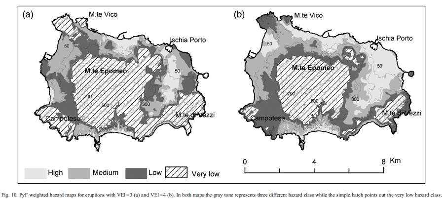
Figure in a journal article
PyF weighted hazard maps for eruptions with VEI=3 and VEI=4
Figure 10 in: Alberico, I., Lirer, L., Petrosino, P., & Scandone, R. (2008). Volcanic hazard and risk assessment from pyroclastic flows at Ischia island (southern Italy). Journal of volcanology and geothermal research, 171(1-2), 118-136.

Figure in a journal article
Pyroclast flow hazard map for NW St Kitts, showing location of principal settlements and estates referred to in text
Figure 6 in: Baker, P. E. (1985). Volcanic hazards on St Kitts and Montserrat, West Indies. Journal of the Geological Society 142 (2): 279–295. https://doi.org/10.1144/gsjgs.142.2.0279
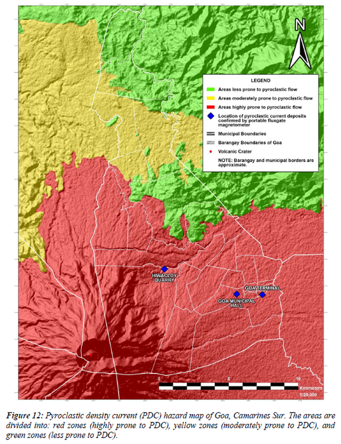
Figure in a thesis or dissertation
Pyroclastic density current (PDC) hazard map of Goa, Camarines Sur
Figure 12 in: Daita, T.J.E. (2020). Preliminary Volcanic Hazard Assessment of Goa, Camarines Sur, Philippines. Thesis, Partido State University, Goa, Camarines Sur, Philippines.