
Advanced Search for Maps
Showing 11-20 of 49
Official, Figure in hazard assessment
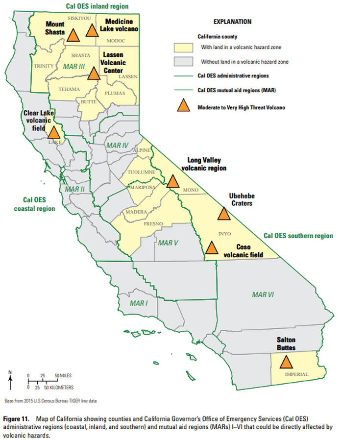
Map of California showing counties and California Governor’s Office of Emergency Services (Cal OES) administrative regions (coastal, inland, and southern) and mutual aid regions (MARs) I–VI that could be directly affected by volcanic hazards.
Figure 11 in: Mangan, M., Ball, J., Wood, N., Jones, J.L., Peters, J., Abdollahian, N., Dinitz, L., Blankenheim, S., Fenton, J., & Pridmore, C. (2019). California’s exposure to volcanic hazards. U.S. Geological Survey Scientific Investigations Report 2018–5159, v. 1.1, 49 p. https://doi.org/10.3133/sir20185159
Official, Figure in hazard assessment
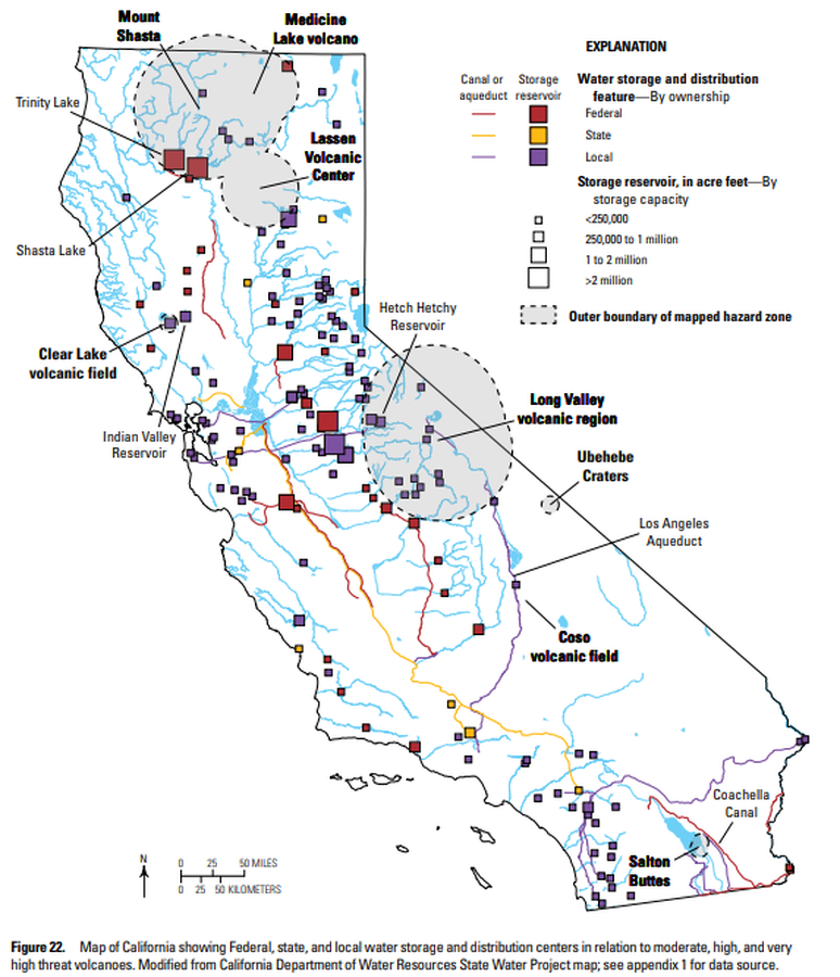
Map of California showing Federal, state, and local water storage and distribution centers in relation to moderate, high, and very high threat volcanoes
Figure 22 in: Mangan, M., Ball, J., Wood, N., Jones, J.L., Peters, J., Abdollahian, N., Dinitz, L., Blankenheim, S., Fenton, J., & Pridmore, C. (2019). California’s exposure to volcanic hazards. U.S. Geological Survey Scientific Investigations Report 2018–5159, v. 1.1, 49 p. https://doi.org/10.3133/sir20185159
Official, Figure in hazard assessment
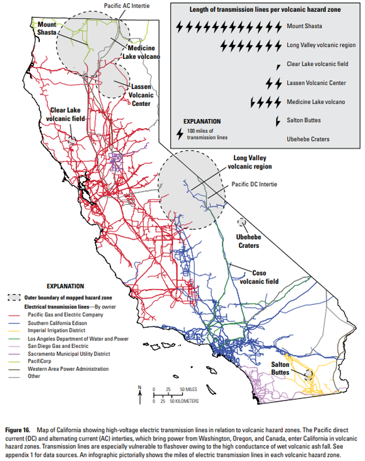
Map of California showing high-voltage electric transmission lines in relation to volcanic hazard zones
Figure 16 in: Mangan, M., Ball, J., Wood, N., Jones, J.L., Peters, J., Abdollahian, N., Dinitz, L., Blankenheim, S., Fenton, J., & Pridmore, C. (2019). California’s exposure to volcanic hazards. U.S. Geological Survey Scientific Investigations Report 2018–5159, v. 1.1, 49 p. https://doi.org/10.3133/sir20185159
Official, Figure in hazard assessment
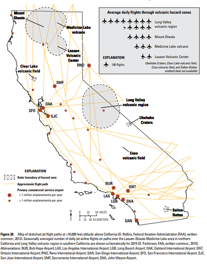
Map of sketched jet flight paths at >18,000 feet altitude above California
Figure 28 in: Mangan, M., Ball, J., Wood, N., Jones, J.L., Peters, J., Abdollahian, N., Dinitz, L., Blankenheim, S., Fenton, J., & Pridmore, C. (2019). California’s exposure to volcanic hazards. U.S. Geological Survey Scientific Investigations Report 2018–5159, v. 1.1, 49 p. https://doi.org/10.3133/sir20185159
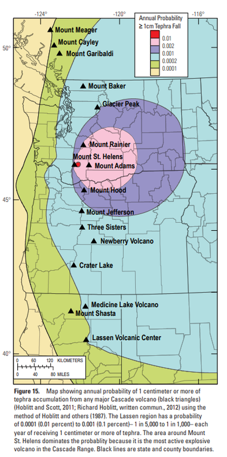
Official, Figure in hazard assessment
Map showing annual probability of 1 centimeter or more of tephra accumulation from any major Cascade volcano
Figure 15 in: Clynne, M. A., Robinson, J. E., Nathenson, M. & Muffler, L. P. (2012). Volcano hazards assessment for the Lassen region, northern California. U.S. Geological Survey, Scientific Investigations Report 2012-5176-A, 47 p., 1 plate. https://doi.org/10.3133/sir20125176A
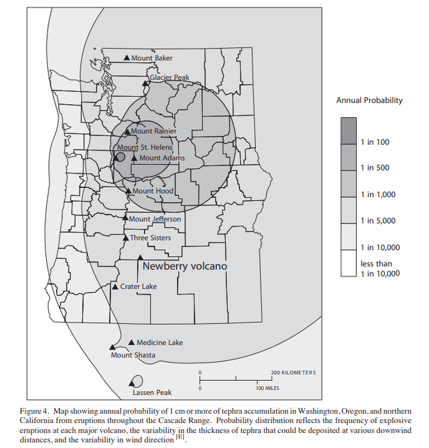
Official, Figure in hazard assessment
Map showing annual probability of 1 cm or more of tephra accumulation in Washington, Oregon, and northern California from eruptions throughout the Cascade Range.
Figure 4 in: Sherrod, D.R., Mastin, L.G., Scott, W.E. & Schilling, S.P. (1997). Volcano hazards at Newberry Volcano, Oregon. U.S. Geological Survey, Open-File Report 97-513, 14 p. https://doi.org/10.3133/ofr97513
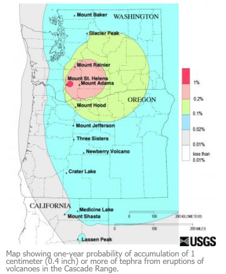
Official, Figure on website
Map showing one-year probability of accumulation of 1 centimeter (0.4 inch) or more of tephra from eruptions of volcanoes in the Cascade Range.
Nathensen, M. (2013). Map showing one-year probability of accumulation of 1 centimeter (0.4 inch) or more of tephra from eruptions of volcanoes in the Cascade Range. U.S. Geological Survey. Mount Bachelor Hazards. https://www.usgs.gov/volcanoes/mount-bachelor/hazards
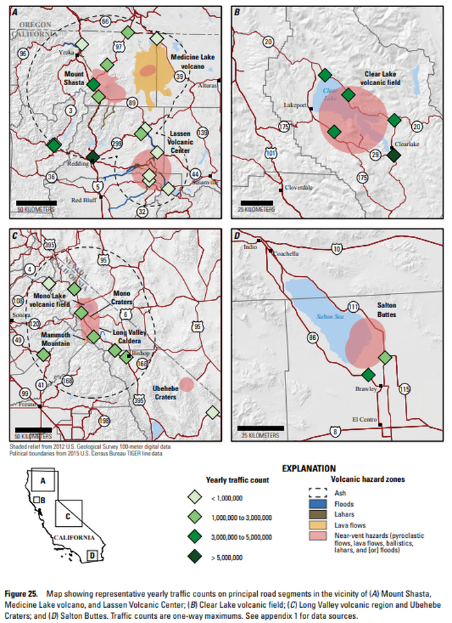
Official, Figure in hazard assessment
Map showing representative yearly traffic counts on principal road segments in the vicinity of (A) Mount Shasta, Medicine Lake volcano, and Lassen Volcanic Center; (B) Clear Lake volcanic field; (C ) Long Valley volcanic region and Ubehebe Craters; and (D) Salton Buttes
Figure 25 in: Mangan, M., Ball, J., Wood, N., Jones, J.L., Peters, J., Abdollahian, N., Dinitz, L., Blankenheim, S., Fenton, J., & Pridmore, C. (2019). California’s exposure to volcanic hazards. U.S. Geological Survey Scientific Investigations Report 2018–5159, v. 1.1, 49 p. https://doi.org/10.3133/sir20185159
Official, Figure in hazard assessment
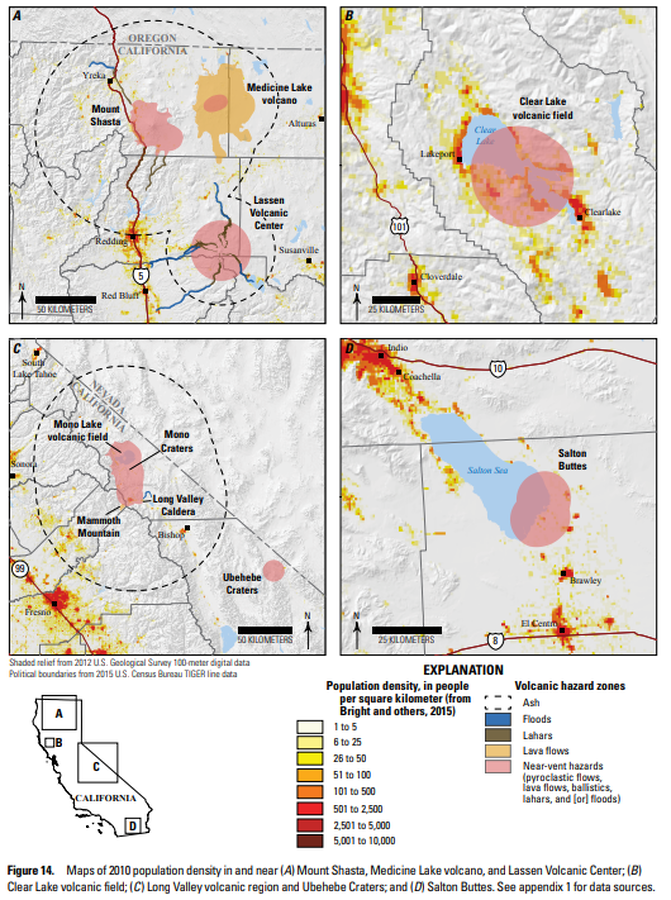
Maps of 2010 population density in and near (A) Mount Shasta, Medicine Lake volcano, and Lassen Volcanic Center; (B ) Clear Lake volcanic field; (C ) Long Valley volcanic region and Ubehebe Craters; and (D ) Salton Buttes
Figure 14 in: Mangan, M., Ball, J., Wood, N., Jones, J.L., Peters, J., Abdollahian, N., Dinitz, L., Blankenheim, S., Fenton, J., & Pridmore, C. (2019). California’s exposure to volcanic hazards. U.S. Geological Survey Scientific Investigations Report 2018–5159, v. 1.1, 49 p. https://doi.org/10.3133/sir20185159
Official, Figure in hazard assessment
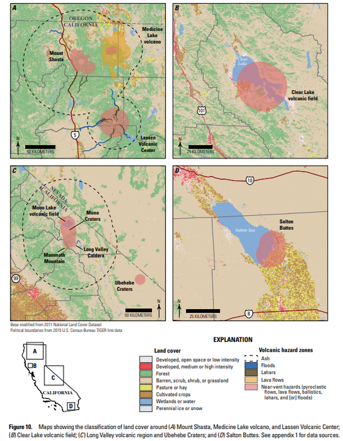
Maps showing the classification of land cover around (A) Mount Shasta, Medicine Lake volcano, and Lassen Volcanic Center; (B) Clear Lake volcanic field; (C ) Long Valley volcanic region and Ubehebe Craters; and (D) Salton Buttes
Figure 10 in: Mangan, M., Ball, J., Wood, N., Jones, J.L., Peters, J., Abdollahian, N., Dinitz, L., Blankenheim, S., Fenton, J., & Pridmore, C. (2019). California’s exposure to volcanic hazards. U.S. Geological Survey Scientific Investigations Report 2018–5159, v. 1.1, 49 p. https://doi.org/10.3133/sir20185159