Advanced Search for Maps
Showing 11-20 of 21
Taranaki, New Zealand
Official, Figure in hazard assessment
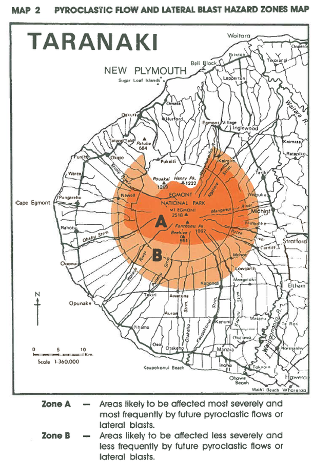
Pyroclastic Flow and Lateral Blast Hazard Zones Map
Map 2, Page 17 in: Neall, V.E. & Alloway, B.V. (1993). Volcanic hazards at Egmont volcano. Volcanic Hazards Working Group of the Scientific Advisory Committee, Ministry of Civil Defence. Volcanic Hazards Information Series, Number One, 2nd ed. 31 p.
Egmont (Taranaki), New Zealand
Figure in a journal article
Risk zones for future ground-hugging volcanic hazards at Mt. Egmont.
Figure 11 in: Dibble, R.R., Nairn, I.A., & Neall, V.E. (1985). Volcanic hazards of North Island, New Zealand--Overview. Journal of Geodynamics, 3, p. 369-396. https://doi.org/10.1016/0264-3707(85)90043-2
Taranaki, New Zealand
Official, Map sheet or poster
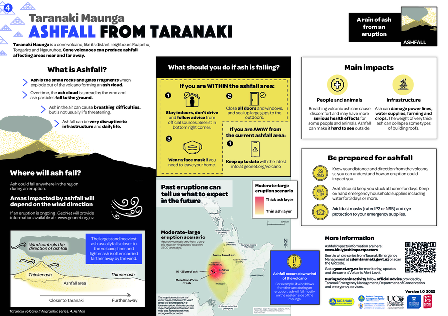
Taranaki Maunga Ashfall from Taranaki
Taranaki Emergency Management. (2022). Taranaki Maunga. Ashfall from Taranaki. Version 1.0. https://cdemtaranaki.govt.nz/assets/Volcano-infographics/Ashfall.PDF
Official, Map sheet or poster
Taranaki Maunga Ashfall from Taranaki
Taranaki Emergency Management. (2022). Taranaki Maunga. Ashfall from Taranaki. Version 1.0. https://cdemtaranaki.govt.nz/assets/Volcano-infographics/Ashfall.PDF
Taranaki, New Zealand
Official, Map sheet or poster
Taranaki Maunga Debris Avalanches from Taranaki
Taranaki Emergency Management. (2022). Taranaki Maunga. Debris Avalanches from Taranaki Version 1.0. https://cdemtaranaki.govt.nz/assets/Volcano-infographics/Debris-avalanches.PDF
Official, Map sheet or poster
Taranaki Maunga Debris Avalanches from Taranaki
Taranaki Emergency Management. (2022). Taranaki Maunga. Debris Avalanches from Taranaki Version 1.0. https://cdemtaranaki.govt.nz/assets/Volcano-infographics/Debris-avalanches.PDF
Taranaki, New Zealand
Official, Map sheet or poster
Taranaki Maunga Lahars from Taranaki
Taranaki Emergency Management. (2022). Taranaki Maunga. Lahars from Taranaki Version 1.0. https://cdemtaranaki.govt.nz/assets/Volcano-infographics/Lahars.PDF
Official, Map sheet or poster
Taranaki Maunga Lahars from Taranaki
Taranaki Emergency Management. (2022). Taranaki Maunga. Lahars from Taranaki Version 1.0. https://cdemtaranaki.govt.nz/assets/Volcano-infographics/Lahars.PDF
Taranaki, New Zealand
Official, Map sheet or poster
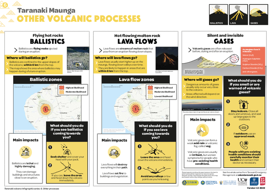
Taranaki Maunga Other Volcanic Processes
Taranaki Emergency Management. (2022). Taranaki Maunga. Other Volcanic Processes. Version 1.0. https://cdemtaranaki.govt.nz/assets/Volcano-infographics/ballistics-lava-gases.PDF
Official, Map sheet or poster
Taranaki Maunga Other Volcanic Processes
Taranaki Emergency Management. (2022). Taranaki Maunga. Other Volcanic Processes. Version 1.0. https://cdemtaranaki.govt.nz/assets/Volcano-infographics/ballistics-lava-gases.PDF
Taranaki, New Zealand
Official, Map sheet or poster
Taranaki Maunga Pyroclastic Flows from Taranaki
Taranaki Emergency Management. (2022). Taranaki Maunga. Pyroclastic Flows from Taranaki Version 1.0. https://cdemtaranaki.govt.nz/assets/Volcano-infographics/Pyroclastic-flows.PDF
Official, Map sheet or poster
Taranaki Maunga Pyroclastic Flows from Taranaki
Taranaki Emergency Management. (2022). Taranaki Maunga. Pyroclastic Flows from Taranaki Version 1.0. https://cdemtaranaki.govt.nz/assets/Volcano-infographics/Pyroclastic-flows.PDF
Taranaki, New Zealand
Figure in a journal article
Taranaki volcanic hazard map and zones from Neall and Alloway (1996)
Figure 2 in: Mead, S., Procter, J., Bebbington, M., & Rodriguez-Gomez, C. (2022). Probabilistic Volcanic Hazard Assessment for National Park Infrastructure Proximal to Taranaki Volcano (New Zealand). Frontiers in Earth Science, 435. https://doi.org/10.3389/feart.2022.832531. Simplified from: Neall, V. E., & Alloway, B. V. (1996). Volcanic hazard map of Western Taranaki. Massey University, Department of Soil Science Report, 12.
Egmont (Taranaki), New Zealand
Official, Figure in hazard assessment
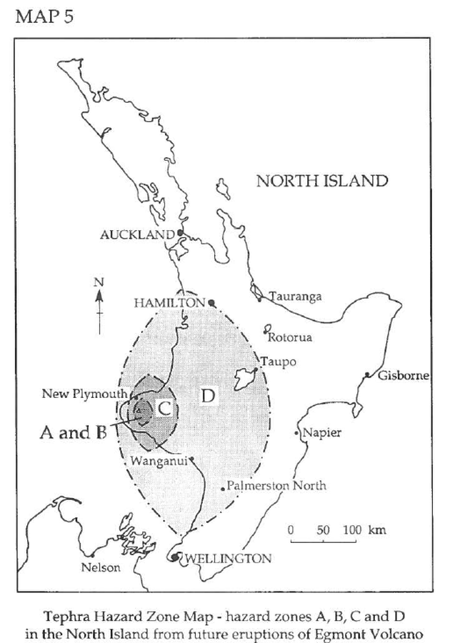
Tephra Hazard Zone Map - hazard zones A, B, C, and D in the North Island from future eruptions of Egmont Volcano
Map 5, Page 27 in: Neall, V.E. & Alloway, B.V. (1993). Volcanic hazards at Egmont volcano. Volcanic Hazards Working Group of the Scientific Advisory Committee, Ministry of Civil Defence. Volcanic Hazards Information Series, Number One, 2nd ed. 31 p.
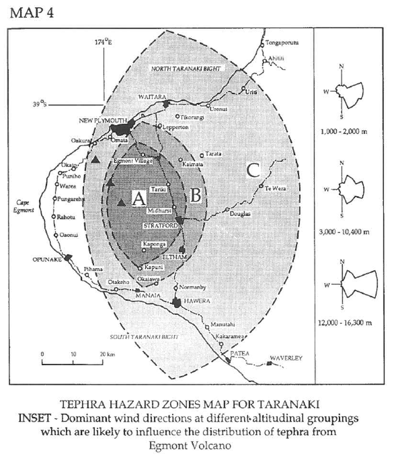
Taranaki, New Zealand
Official, Figure in hazard assessment
Tephra Hazard Zones Map for Taranaki
Map 4, Page 25 in: Neall, V.E. & Alloway, B.V. (1993). Volcanic hazards at Egmont volcano. Volcanic Hazards Working Group of the Scientific Advisory Committee, Ministry of Civil Defence. Volcanic Hazards Information Series, Number One, 2nd ed. 31 p.