
Advanced Search for Maps
Showing 11-20 of 27

Official, Figure in hazard assessment
Map of natural gas pipelines and substations in northern California
Figure 20 in: Mangan, M., Ball, J., Wood, N., Jones, J.L., Peters, J., Abdollahian, N., Dinitz, L., Blankenheim, S., Fenton, J., & Pridmore, C. (2019). California’s exposure to volcanic hazards. U.S. Geological Survey Scientific Investigations Report 2018–5159, v. 1.1, 49 p. https://doi.org/10.3133/sir20185159
Official, Figure in hazard assessment
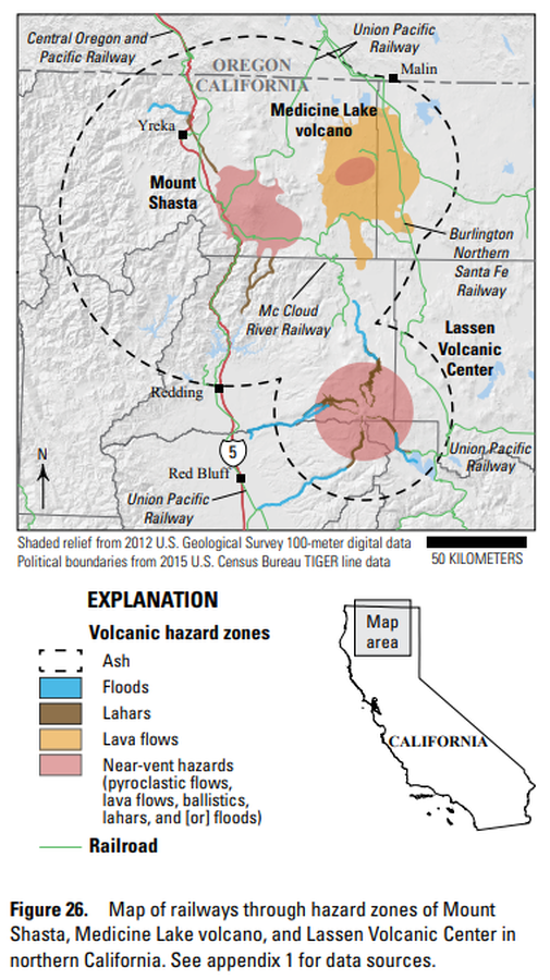
Map of railways through hazard zones of Mount Shasta, Medicine Lake volcano, and Lassen Volcanic Center in northern California
Figure 26 in: Mangan, M., Ball, J., Wood, N., Jones, J.L., Peters, J., Abdollahian, N., Dinitz, L., Blankenheim, S., Fenton, J., & Pridmore, C. (2019). California’s exposure to volcanic hazards. U.S. Geological Survey Scientific Investigations Report 2018–5159, v. 1.1, 49 p. https://doi.org/10.3133/sir20185159
Official, Figure in hazard assessment
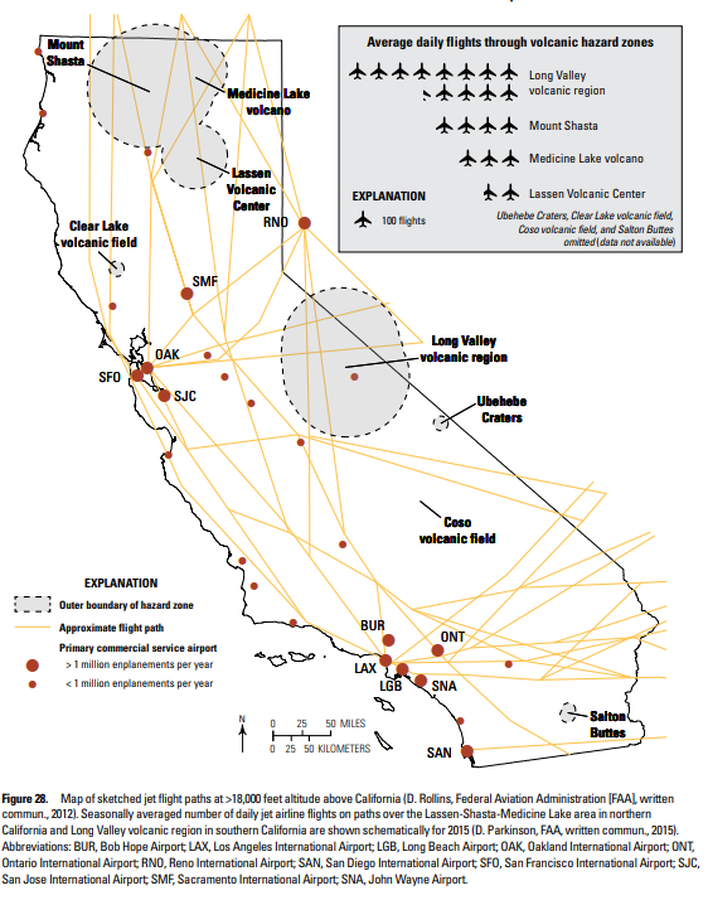
Map of sketched jet flight paths at >18,000 feet altitude above California
Figure 28 in: Mangan, M., Ball, J., Wood, N., Jones, J.L., Peters, J., Abdollahian, N., Dinitz, L., Blankenheim, S., Fenton, J., & Pridmore, C. (2019). California’s exposure to volcanic hazards. U.S. Geological Survey Scientific Investigations Report 2018–5159, v. 1.1, 49 p. https://doi.org/10.3133/sir20185159
Official, Figure in hazard assessment
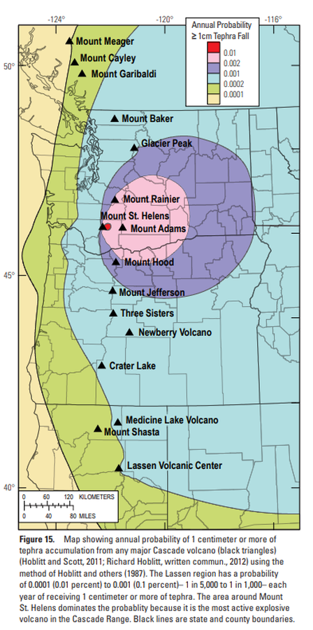
Map showing annual probability of 1 centimeter or more of tephra accumulation from any major Cascade volcano
Figure 15 in: Clynne, M. A., Robinson, J. E., Nathenson, M. & Muffler, L. P. (2012). Volcano hazards assessment for the Lassen region, northern California. U.S. Geological Survey, Scientific Investigations Report 2012-5176-A, 47 p., 1 plate. https://doi.org/10.3133/sir20125176A
Official, Figure in hazard assessment
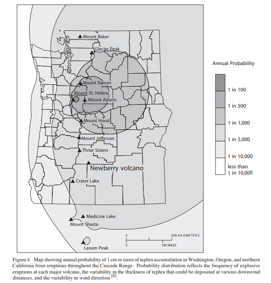
Map showing annual probability of 1 cm or more of tephra accumulation in Washington, Oregon, and northern California from eruptions throughout the Cascade Range.
Figure 4 in: Sherrod, D.R., Mastin, L.G., Scott, W.E. & Schilling, S.P. (1997). Volcano hazards at Newberry Volcano, Oregon. U.S. Geological Survey, Open-File Report 97-513, 14 p. https://doi.org/10.3133/ofr97513

Official, Figure on website
Map showing caldera features and caldera-related hazards at Medicine Lake volcano
U.S. Geological Survey (USGS). (2008). Map showing caldera features and caldera-related hazards at Medicine Lake volcano. U.S. Geological Survey. Medicine Lake Hazards. https://www.usgs.gov/volcanoes/medicine-lake/hazards (Modified from: Scientitic Investigations Report 2007-5174-A)

Official, Figure in hazard assessment
Map showing caldera features and caldera-related hazards at Medicine Lake volcano
Figure 13 in: Donnelly-Nolan, J.M., Nathenson, M., Champion, D.E., Ramsey, D.W., Lowenstern, J.B., & Ewert, J.W. (2007). Volcano Hazards Assessment for Medicine Lake Volcano, Northern California. Scientitic Investigations Report 2007-5174-A. Plate 1. https://doi.org/10.3133/sir20075174A
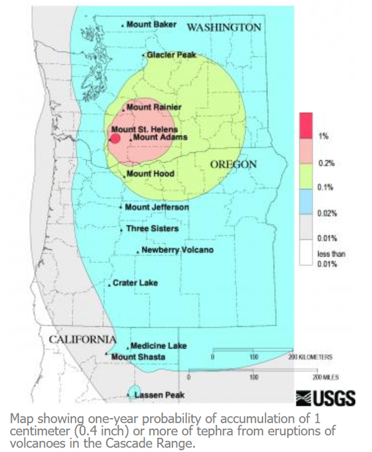
Official, Figure on website
Map showing one-year probability of accumulation of 1 centimeter (0.4 inch) or more of tephra from eruptions of volcanoes in the Cascade Range.
Nathensen, M. (2013). Map showing one-year probability of accumulation of 1 centimeter (0.4 inch) or more of tephra from eruptions of volcanoes in the Cascade Range. U.S. Geological Survey. Mount Bachelor Hazards. https://www.usgs.gov/volcanoes/mount-bachelor/hazards
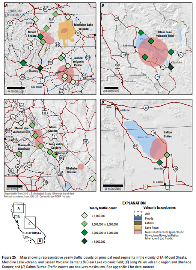
Official, Figure in hazard assessment
Map showing representative yearly traffic counts on principal road segments in the vicinity of (A) Mount Shasta, Medicine Lake volcano, and Lassen Volcanic Center; (B) Clear Lake volcanic field; (C ) Long Valley volcanic region and Ubehebe Craters; and (D) Salton Buttes
Figure 25 in: Mangan, M., Ball, J., Wood, N., Jones, J.L., Peters, J., Abdollahian, N., Dinitz, L., Blankenheim, S., Fenton, J., & Pridmore, C. (2019). California’s exposure to volcanic hazards. U.S. Geological Survey Scientific Investigations Report 2018–5159, v. 1.1, 49 p. https://doi.org/10.3133/sir20185159
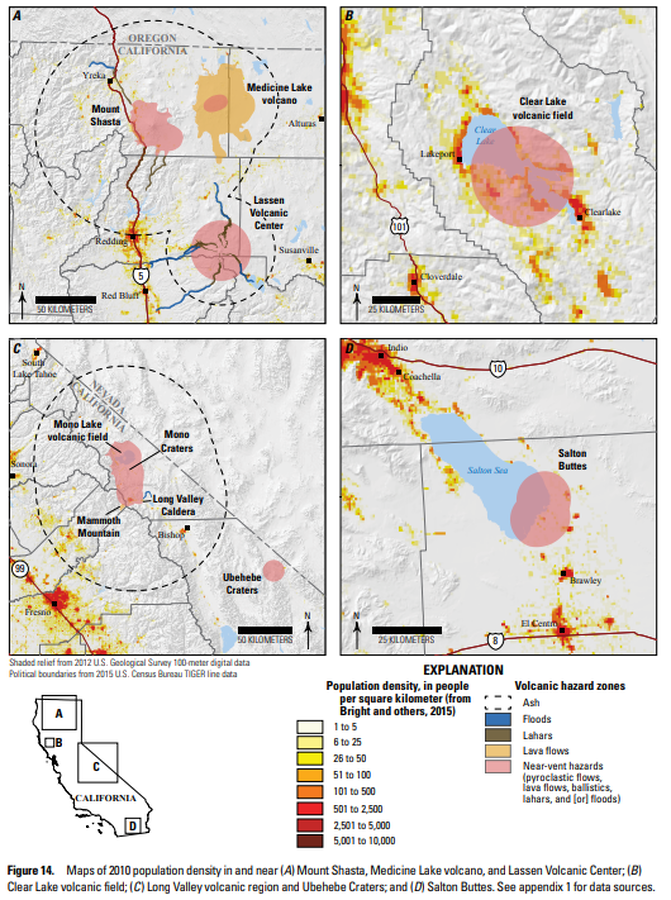
Official, Figure in hazard assessment
Maps of 2010 population density in and near (A) Mount Shasta, Medicine Lake volcano, and Lassen Volcanic Center; (B ) Clear Lake volcanic field; (C ) Long Valley volcanic region and Ubehebe Craters; and (D ) Salton Buttes
Figure 14 in: Mangan, M., Ball, J., Wood, N., Jones, J.L., Peters, J., Abdollahian, N., Dinitz, L., Blankenheim, S., Fenton, J., & Pridmore, C. (2019). California’s exposure to volcanic hazards. U.S. Geological Survey Scientific Investigations Report 2018–5159, v. 1.1, 49 p. https://doi.org/10.3133/sir20185159