
Advanced Search for Maps
Showing 21-30 of 93
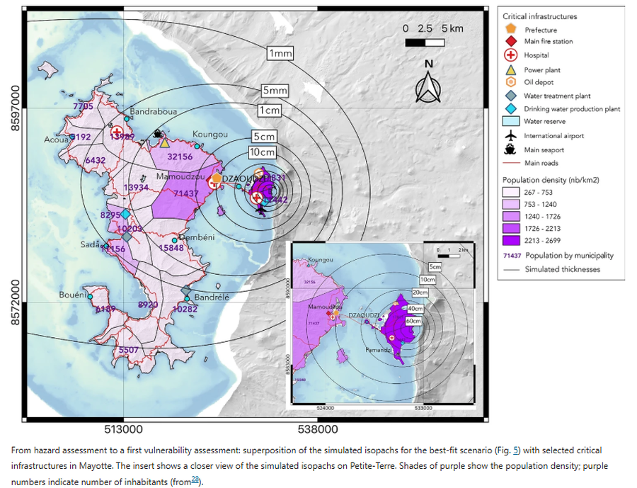
Figure in a journal article
From hazard assessment to a first vulnerability assessment
Figure 6 in: Michaud-Dubuy, A., Komorowski, J. C., Lacombe, T., & Gurioli, L. (2024). Tephra fallout hazard assessment for a hydrovolcanic eruptive scenario in Mayotte. Scientific Reports, 14(1), 31880.
Official, Figure in hazard assessment
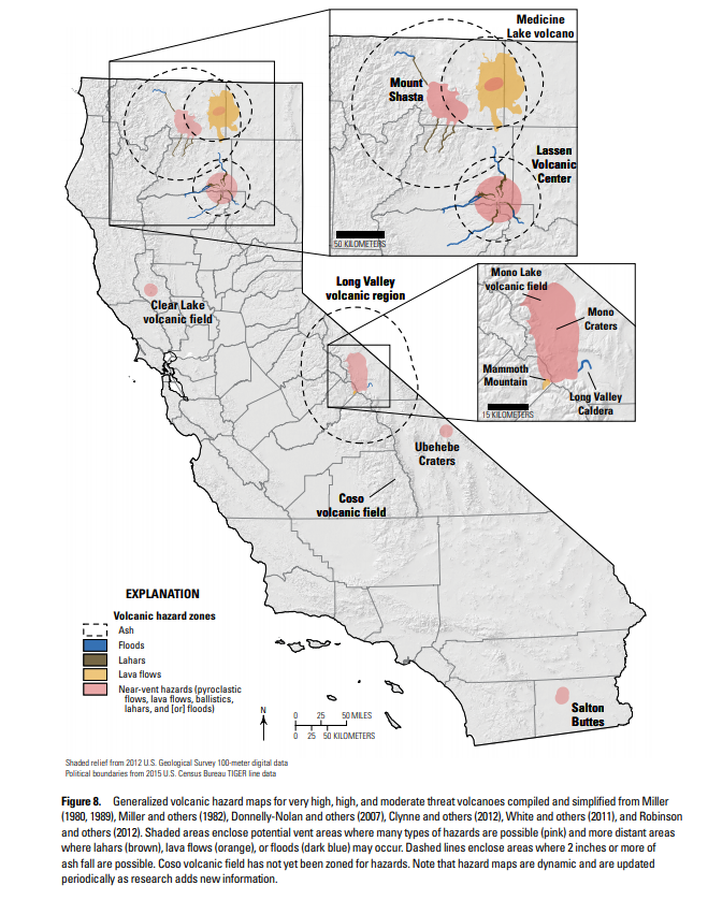
Generalized volcanic hazard maps for very high, high, and moderate threat volcanoes compiled and simplified from Miller (1980, 1989), Miller and others (1982), Donnelly-Nolan and others (2007), Clynne and others (2012), White and others (2011), and Robinson and others (2012)
Figure 8 in: Mangan, M., Ball, J., Wood, N., Jones, J.L., Peters, J., Abdollahian, N., Dinitz, L., Blankenheim, S., Fenton, J., & Pridmore, C. (2019). California’s exposure to volcanic hazards. U.S. Geological Survey Scientific Investigations Report 2018–5159, v. 1.1, 49 p. https://doi.org/10.3133/sir20185159
Official, Figure in hazard assessment
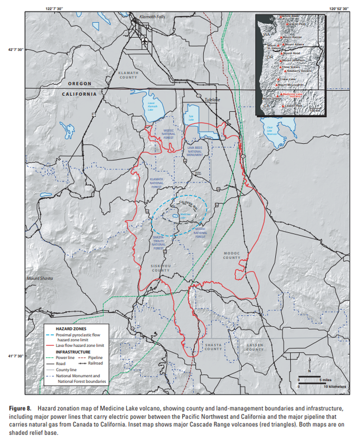
Hazard zonation map of Medicine Lake volcano, showing county and land-management boundaries and infrastructure
Figure 8 in: Donnelly-Nolan, J.M., Nathenson, M., Champion, D.E., Ramsey, D.W., Lowenstern, J.B., & Ewert, J.W. (2007). Volcano Hazards Assessment for Medicine Lake Volcano, Northern California. Scientitic Investigations Report 2007-5174-A. Plate 1. https://doi.org/10.3133/sir20075174A
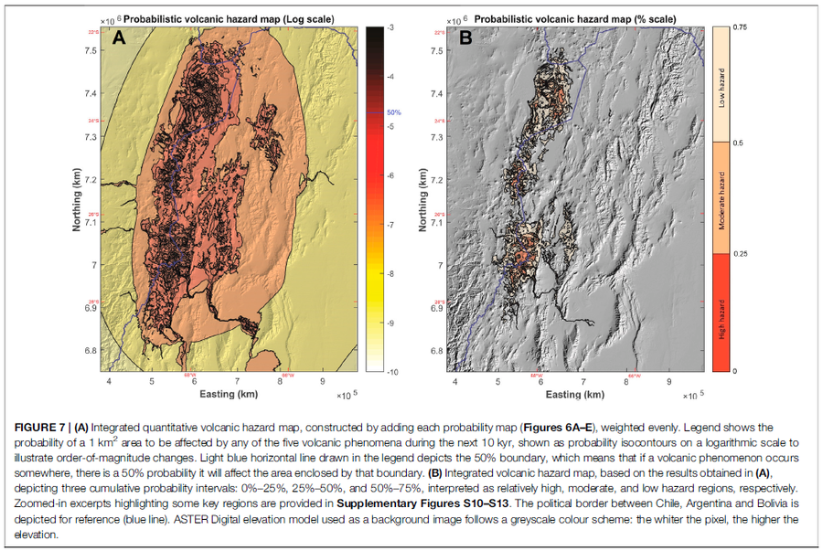
Figure in a journal article
Integrated quantitative volcanic hazard map, constructed by adding each probability map (Figures 6A–E), weighted evenly
Figure 7 in: Bertin, D., Lindsay, J.M., Cronin, S.J., de Silva, S.L., Connor, C.B., Caffe, P.J., Grosse, P., Báez, W., Bustos, E., & Constantinescu, R. (2022). Probabilistic Volcanic Hazard Assessment of the 22.5–28° S Segment of the Central Volcanic Zone of the Andes. Frontiers in Earth Science, 10. https://doi.org/10.3389/feart.2022.875439
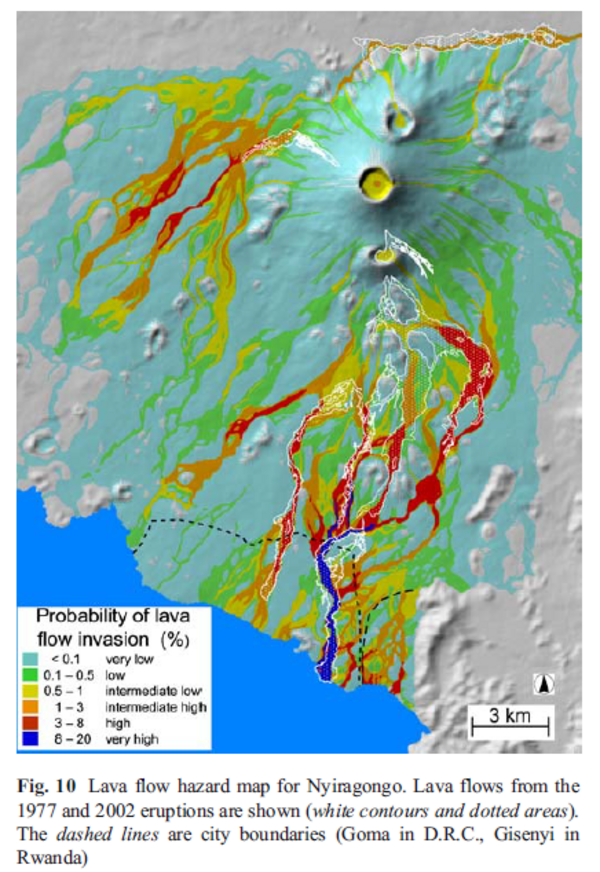
Figure in a journal article
Lava flow hazard map for Nyiragongo
Figure 10 in: Favalli, M., Chirico, G. D., Papale, P., Pareschi, M. T., & Boschi, E. (2009). Lava flow hazard at Nyiragongo volcano, DRC. Bulletin of volcanology, 71(4), p. 363-374. https://doi.org/10.1007/s00445-008-0233-y
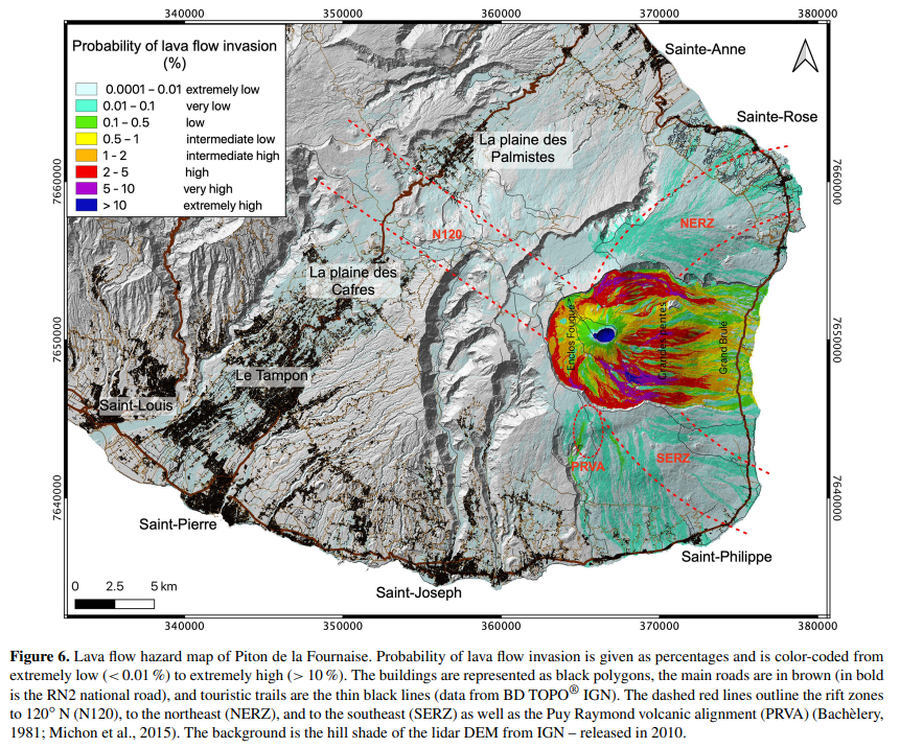
Figure in a journal article
Lava flow hazard map of Piton de la Fournaise
Figure 6 in: Chevrel, M. O., Favalli, M., Villeneuve, N., Harris, A. J., Fornaciai, A., Richter, N., Derrien, A., Di Muro, A., & Peltier, A. (2021). Lava flow hazard map of Piton de la Fournaise volcano. Natural Hazards and Earth System Sciences, 21(8), 2355-2377. https://doi.org/10.5194/nhess-21-2355-2021, 2021
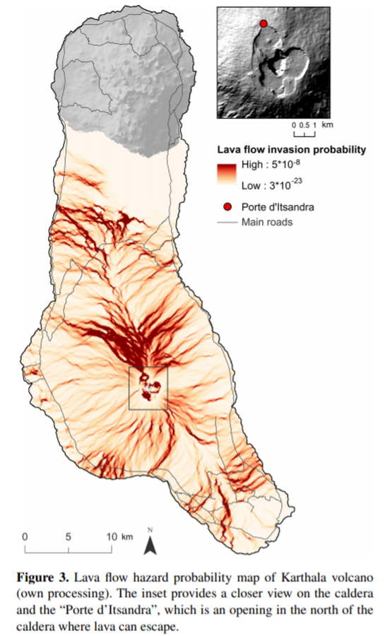
Figure in a journal article
Lava flow hazard probability map of Karthala volcano
Figure 3 in: Mossoux, S., Kervyn, M., & Canters, F. (2019). Assessing the impact of road segment obstruction on accessibility of critical services in case of a hazard. Natural Hazards & Earth System Sciences, 19(6). https://doi.org/10.5194/nhess-19-1251-2019
Official, Map in a booklet, long fact-sheet, or handbook
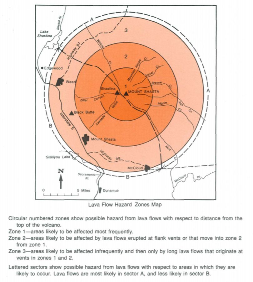
Lava Flow Hazard Zones Map
Page 17 in: Crandell, D.R. & Nichols, D.R. (1989). Volcanic hazards at Mount Shasta, California. U.S. Geological Survey, General Information Product, 22 p. https://doi.org/10.3133/70039409
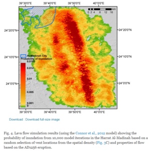
Figure in a journal article
Lava flow simulation results
Figure 4 in: El Difrawy, M. A., Runge, M. G., Moufti, M. R., Cronin, S. J., & Bebbington, M. (2013). A first hazard analysis of the Quaternary Harrat Al-Madinah volcanic field, Saudi Arabia. Journal of Volcanology and Geothermal Research, 267, p. 39-46. https://doi.org/10.1016/j.jvolgeores.2013.09.006
Official, Figure in hazard assessment
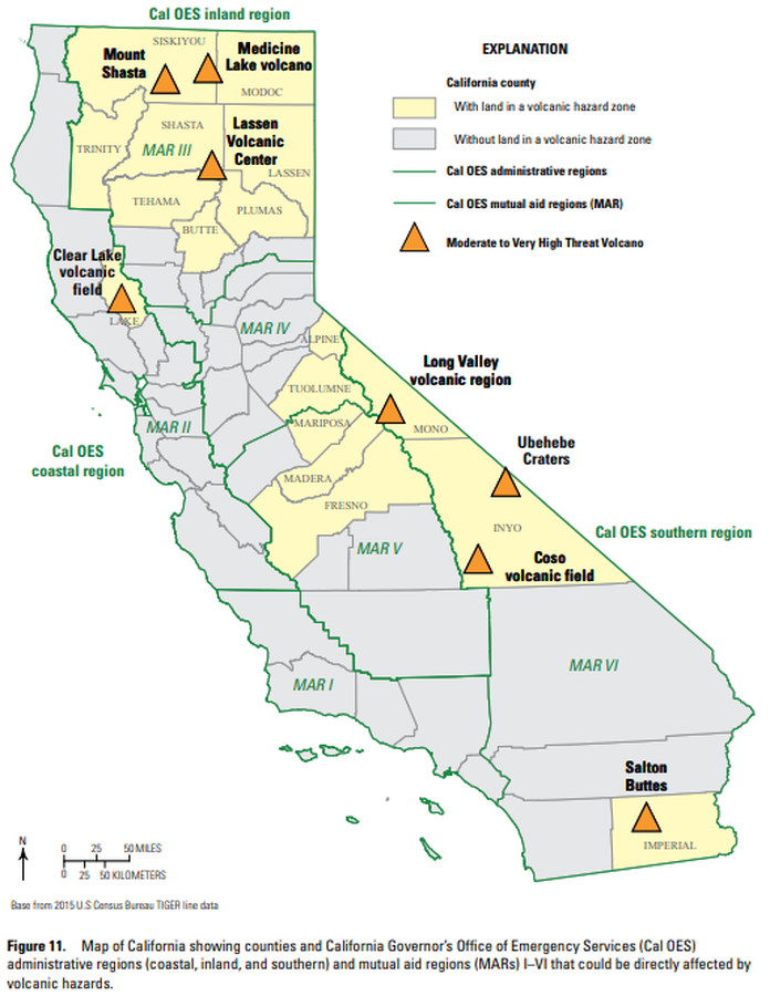
Map of California showing counties and California Governor’s Office of Emergency Services (Cal OES) administrative regions (coastal, inland, and southern) and mutual aid regions (MARs) I–VI that could be directly affected by volcanic hazards.
Figure 11 in: Mangan, M., Ball, J., Wood, N., Jones, J.L., Peters, J., Abdollahian, N., Dinitz, L., Blankenheim, S., Fenton, J., & Pridmore, C. (2019). California’s exposure to volcanic hazards. U.S. Geological Survey Scientific Investigations Report 2018–5159, v. 1.1, 49 p. https://doi.org/10.3133/sir20185159