
Advanced Search for Maps
Showing 131-139 of 139

Official, Sign or billboard
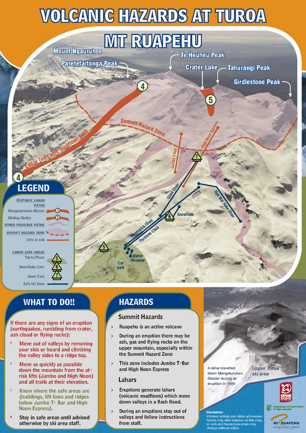
Volcanic Hazards at Tūroa Mt. Ruapehu
GNS Science (compiler). (2019). Volcanic Hazards at Tūroa Mt. Ruapehu. Version 6.0 2019.
Official, Sign or billboard
Volcanic Hazards at Tūroa Mt. Ruapehu
GNS Science (compiler). (2005). Volcanic Hazards at Tūroa Mt. Ruapehu.
Official, Sign or billboard
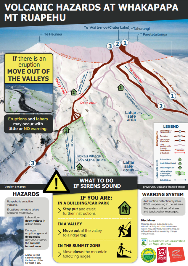
Volcanic Hazards at Whakapapa Mt. Ruapehu
GNS Science (compiler). (2019). Volcanic Hazards at Whakapapa Mt. Ruapehu. Version 6.0 2019.

Official, Sign or billboard
Volcanic Hazards at Whakapapa Mt. Ruapehu
GNS Science (compiler). (2004). Volcanic Hazards at Whakapapa Mt. Ruapehu.

Official, Map in a booklet, long fact-sheet, or handbook
Volcanic-Ash Hazard Area Map
Page 14 in: Crandell, D.R. & Nichols, D.R. (1989). Volcanic hazards at Mount Shasta, California. U.S. Geological Survey, General Information Product, 22 p. https://doi.org/10.3133/70039409

Official, Insert/poster-size map with accompanying report
Volcano hazards in the Three Sisters Region, Oregon
Plate 1 in: Scott, W.E., Iverson, R., Schilling, S.P. & Fisher, B.J. (2001). Volcano Hazards in the Three Sisters Region, Oregon. U.S. Geological Survey, Open-File Report 99-437, 14 p., 1 plate. https://doi.org/10.3133/ofr99437
Official (foreign agency), Insert/poster-size map with accompanying report
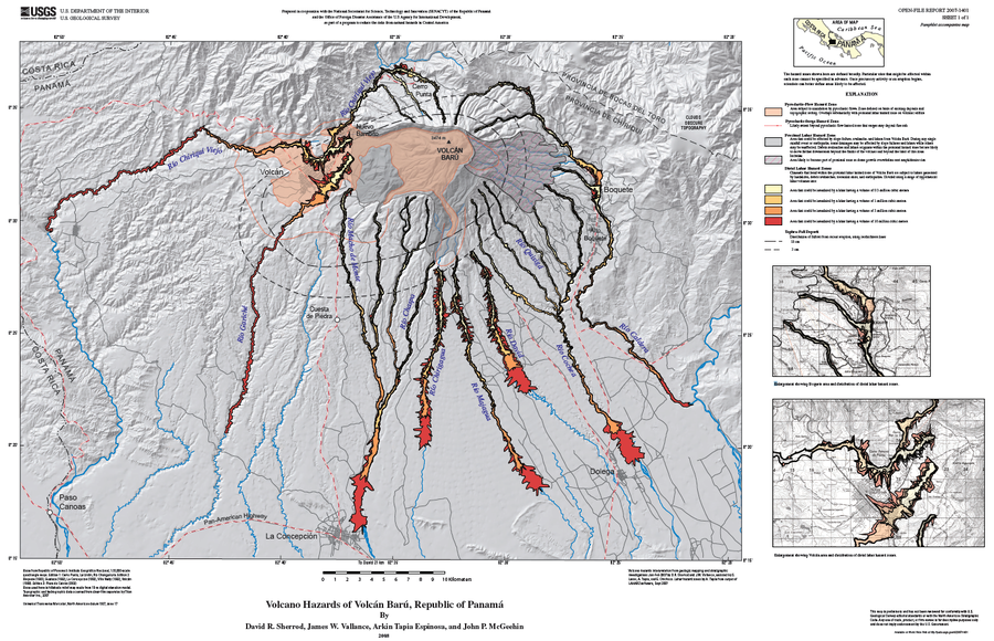
Volcano Hazards of Volcán Barú, Republic of Panamá
Plate 1 (English) in: Sherrod, D. R., Vallance, J. W., Espinosa, A. T., & McGeehin, J. P. (2007). Volcan Baru—eruptive history and volcano-hazards assessment. U.S. Geological Survey, Open-File Report, 2007-1401.
Official, Figure in hazard assessment
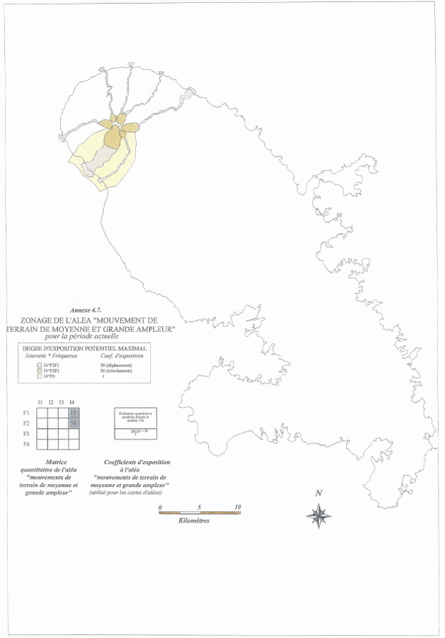
Zonage de L'Aléa "Mouvement de Terrain de Moyenne et Grande Ampleur" pour la période actuelle
(Zoning of the "Medium and Large Scale Land Movement" Hazard for the current period)
Annex 4.7 in: Stieltjes, L. & Mirgon, C. (1998). Approche méthodologique de la vulnérabilité aux phénomènes volcaniques. Test d’application sur les réseaux de la Martinique. Rapport de synthese. Rapport Bureau de Recherches Géologiques et Minières (BRGM), Marseille, R 40098. http://infoterre.brgm.fr/rapports/RR-40098-FR.pdf
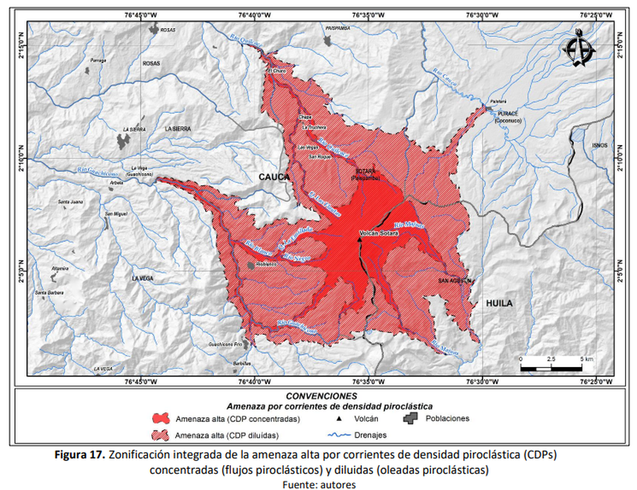
Official, Figure in hazard assessment
Zonificación integrada de la amenaza alta por corrientes de densidad piroclástica (CDPs) concentradas (flujos piroclásticos) y diluidas (oleadas piroclásticas)
(Integrated high hazard zoning of concentrated (pyroclastic flows) and diluted (pyroclastic surges) pyroclastic density currents (PDCs))
Figure 17 in: Pulgarín, B., Zuluaga, I., Galarza, J. Muñoz, C. y Laverde, C. (2019). Memoria del mapa de amenaza volcánica del volcán Sotará. Popayán, Pasto y Bogotá: Servicio Geológico Colombiano.