
Advanced Search for Maps
Showing 211-220 of 220
Official, Insert/poster-size map with accompanying report
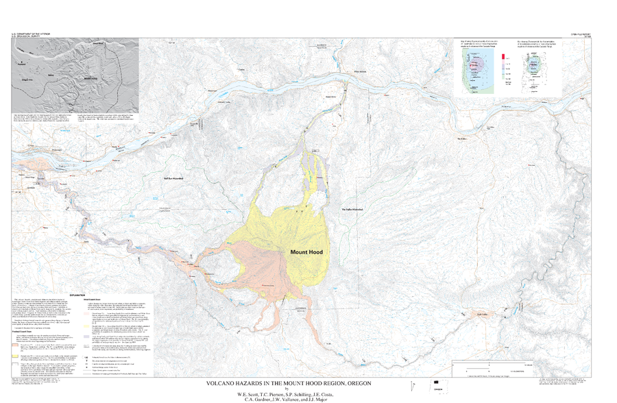
Volcano Hazards in the Mount Hood Region, Oregon
Plate Of1997 in: Scott, W.E., Pierson, T., Schilling, S.P., Costa, J., Gardner, C., Vallance, J.W. & Major, J. (1997). Volcano hazards in the Mount Hood region, Oregon. U.S. Geological Survey, Open-File Report 97-89, 14 p., 1 map. https://doi.org/10.3133/ofr9789
Official, Insert/poster-size map with accompanying report
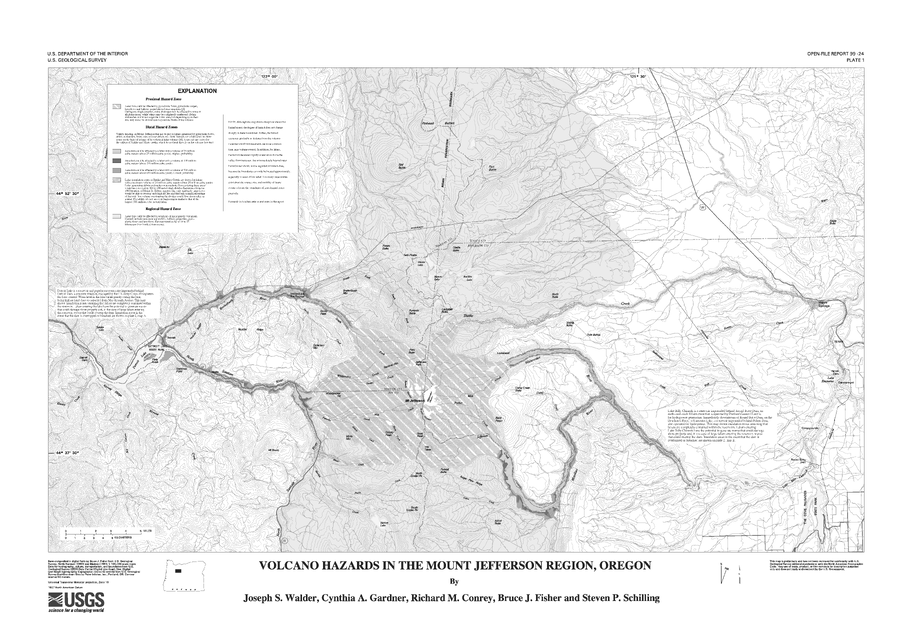
Volcano Hazards in the Mount Jefferson Region, Oregon
Plate 1 in: Walder, J.S., Gardner, C.A., Conrey, R.M., Fisher, B.J., & Schilling, S.P. (1999). Volcano Hazards in the Mount Jefferson Region, Oregon. U.S. Geological Survey, Open-File Report 99-24, 14 p. https://doi.org/10.3133/ofr9924
Official, Insert/poster-size map with accompanying report
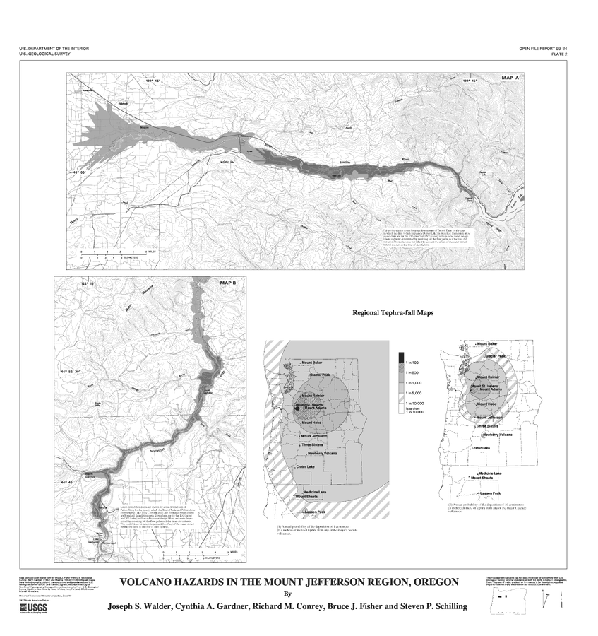
Volcano Hazards in the Mount Jefferson Region, Oregon
Plate 2 in: Walder, J.S., Gardner, C.A., Conrey, R.M., Fisher, B.J., & Schilling, S.P. (1999). Volcano Hazards in the Mount Jefferson Region, Oregon. U.S. Geological Survey, Open-File Report 99-24, 14 p. https://doi.org/10.3133/ofr9924
Official (foreign agency), Insert/poster-size map with accompanying report
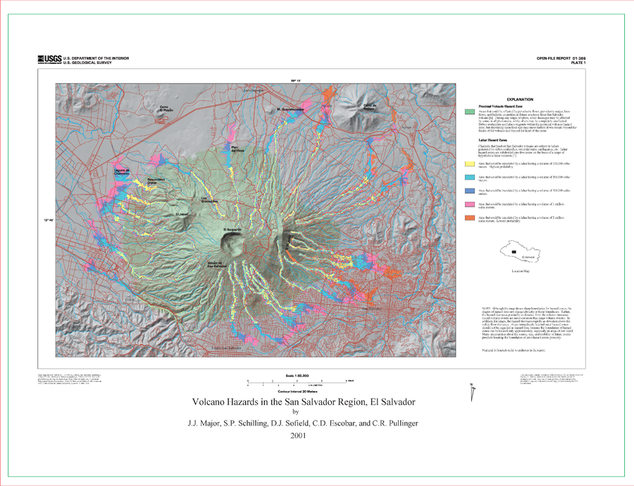
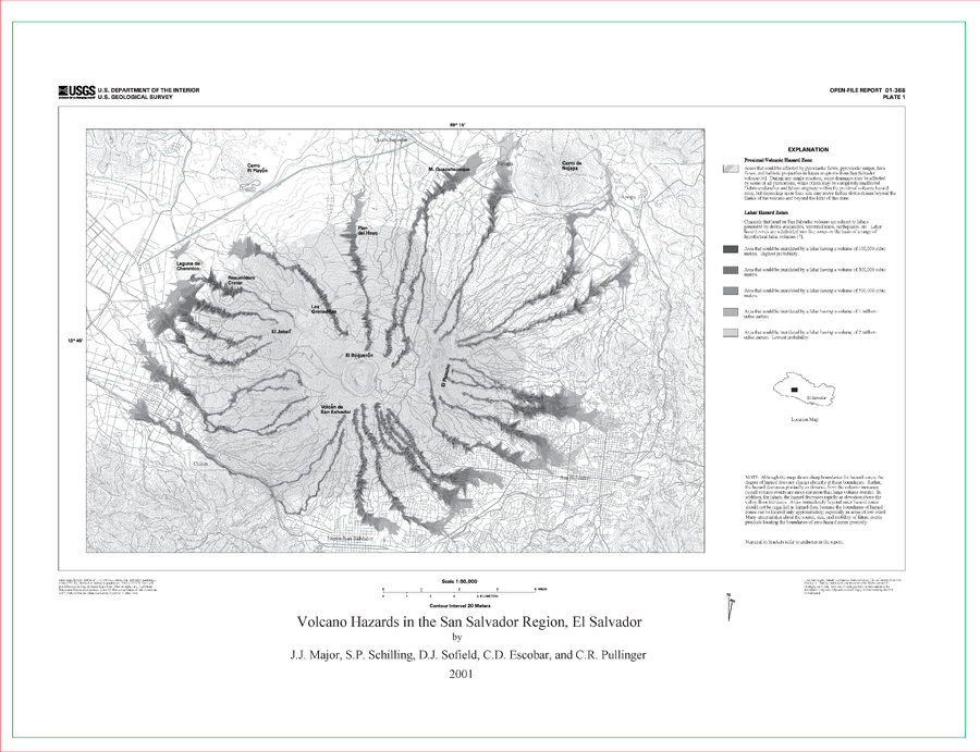
Volcano Hazards in the San Salvador Region, El Salvador
Plate 1 (Color) in: Major, J.J., Schilling, S.P., Sofield, D.J., Escobar, C.D., & Pullinger, C.R. (2001). Volcano Hazards in the San Salvador Region, El Salvador. U.S. Geological Survey, Open-File Report 2001-366, 24 p., 2 plates. https://doi.org/10.3133/ofr01366
Official (foreign agency), Insert/poster-size map with accompanying report
Volcano Hazards in the San Salvador Region, El Salvador
Plate 1 (B&W) in: Major, J.J., Schilling, S.P., Sofield, D.J., Escobar, C.D., & Pullinger, C.R. (2001). Volcano Hazards in the San Salvador Region, El Salvador. U.S. Geological Survey, Open-File Report 2001-366, 24 p., 2 plates. https://doi.org/10.3133/ofr01366

Official, Insert/poster-size map with accompanying report
Volcano hazards in the Three Sisters Region, Oregon
Plate 1 in: Scott, W.E., Iverson, R., Schilling, S.P. & Fisher, B.J. (2001). Volcano Hazards in the Three Sisters Region, Oregon. U.S. Geological Survey, Open-File Report 99-437, 14 p., 1 plate. https://doi.org/10.3133/ofr99437
Official (foreign agency), Insert/poster-size map with accompanying report
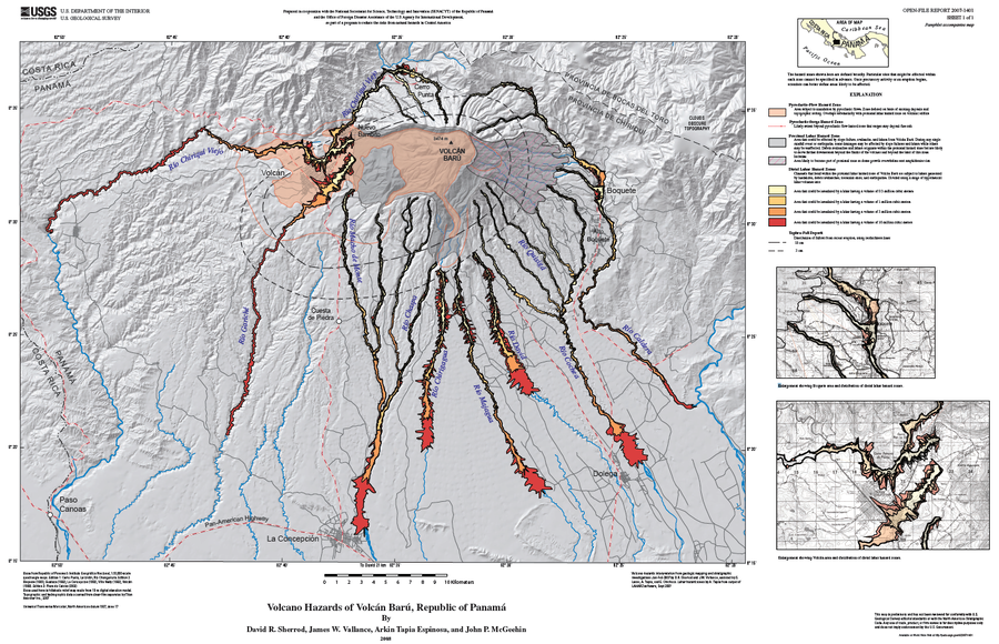
Volcano Hazards of Volcán Barú, Republic of Panamá
Plate 1 (English) in: Sherrod, D. R., Vallance, J. W., Espinosa, A. T., & McGeehin, J. P. (2007). Volcan Baru—eruptive history and volcano-hazards assessment. U.S. Geological Survey, Open-File Report, 2007-1401.
Official, Map in a booklet, long fact-sheet, or handbook
Volcano Information
Nanae Town. (2020). Disaster Prevention Hazard Map for Nanae Town. https://www.town.nanae.hokkaido.jp/hotnews/detail/00009274.html
Official (foreign agency), Insert/poster-size map with accompanying report
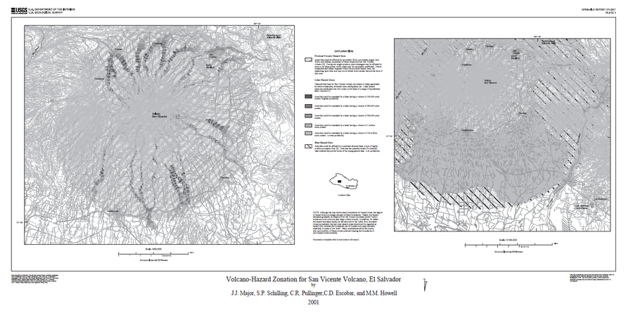
Volcano-Hazard Zonation for San Vicente Volcano, El Salvador
Plate 1 in: Major, J.J., Schilling, S.P., Pullinger, C.R., Escobar, C.D., & Howell, M.M. (2001). Volcano-Hazard Zonation for San Vicente Volcano, El Salvador. U.S. Geological Survey, Open-File Report 2001-367, 22 p., 1 plate. https://doi.org/10.3133/ofr01367
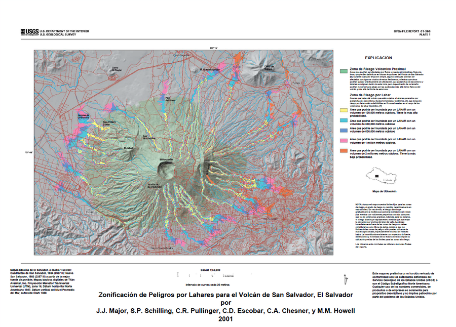
Official (foreign agency), Insert/poster-size map with accompanying report
Zonificación de Peligros por Lahares para el Volcán de San Salvador, El Salvador
(Lahar Hazard Zoning for the San Salvador Volcano, El Salvador)
Plate 1 (Color) in: Major, J.J., Schilling, S.P., Sofield, D.J., Escobar, C.D., & Pullinger, C.R. (2001). Volcano Hazards in the San Salvador Region, El Salvador. U.S. Geological Survey, Open-File Report 2001-366, 24 p., 2 plates. https://doi.org/10.3133/ofr01366