
Advanced Search for Maps
Showing 11-20 of 52
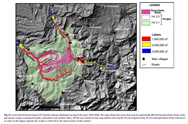
Figure in a journal article
Generalized hazard map of El Chichón volcano displayed on top of the post-1982 DEM
Figure 11 in: Macías, J. L., Capra, L., Arce, J. L., Espíndola, J. M., García-Palomo, A., & Sheridan, M. F. (2008). Hazard map of El Chichón volcano, Chiapas, México: Constraints posed by eruptive history and computer simulations. Journal of Volcanology and Geothermal Research, 175(4), 444-458. https://doi.org/10.1016/j.jvolgeores.2008.02.023
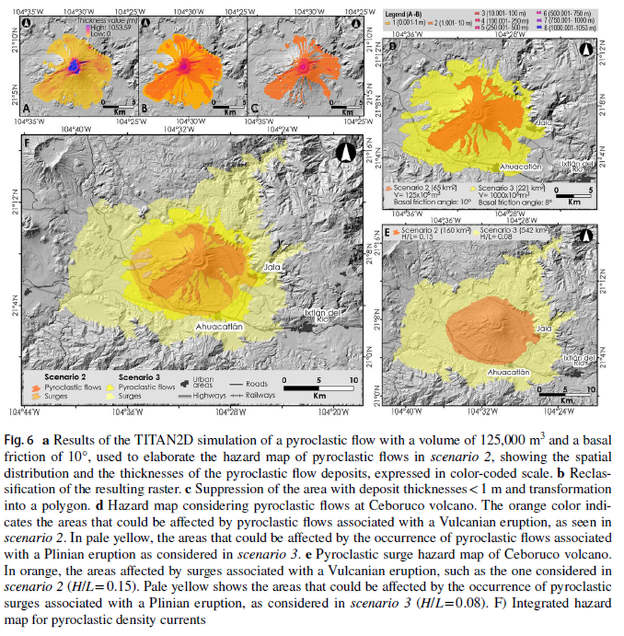
Figure in a journal article
Hazard map considering pyroclastic flows at Ceboruco volcano
Figure 6 in: Sieron, K., Ferrés, D., Siebe, C., Constantinescu, R., Capra, L., Connor, C., Connor, L., Groppelli, G. & Zuccolotto, K.G. (2019). Ceboruco hazard map: part II—modeling volcanic phenomena and construction of the general hazard map. Natural Hazards, 96(2), p. 893-933. https://doi.org/10.1007/s11069-019-03577-5
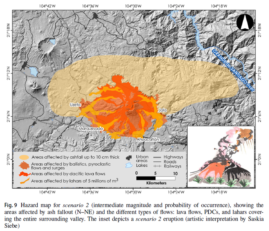
Figure in a journal article
Hazard map for scenario 2 (intermediate magnitude and probability of occurrence), showing the areas affected by ash fallout (N–NE) and the different types of flows: lava flows, PDCs, and lahars covering the entire surrounding valley
Figure 9 in: Sieron, K., Ferrés, D., Siebe, C., Constantinescu, R., Capra, L., Connor, C., Connor, L., Groppelli, G. & Zuccolotto, K.G. (2019). Ceboruco hazard map: part II—modeling volcanic phenomena and construction of the general hazard map. Natural Hazards, 96(2), p. 893-933. https://doi.org/10.1007/s11069-019-03577-5
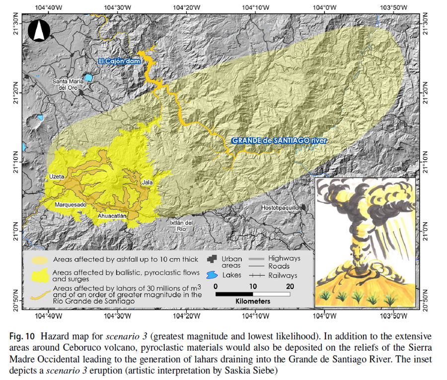
Figure in a journal article
Hazard map for scenario 3 (greatest magnitude and lowest likelihood)
Figure 10 in: Sieron, K., Ferrés, D., Siebe, C., Constantinescu, R., Capra, L., Connor, C., Connor, L., Groppelli, G. & Zuccolotto, K.G. (2019). Ceboruco hazard map: part II—modeling volcanic phenomena and construction of the general hazard map. Natural Hazards, 96(2), p. 893-933. https://doi.org/10.1007/s11069-019-03577-5
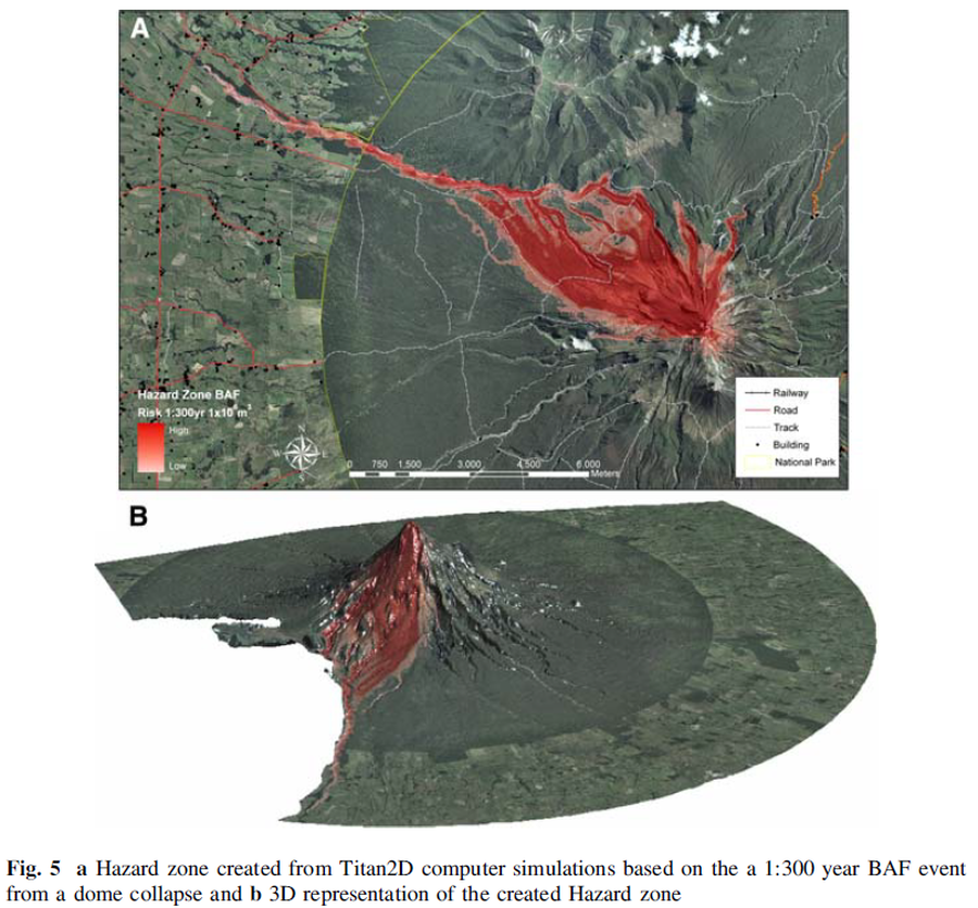
Figure in a journal article
Hazard zone created from Titan2D computer simulations based on the 1:300 year BAF event from a dome collapse and 3D representation of the created Hazard zone
Figure 5 in: Procter, J. N., Cronin, S. J., Platz, T., Patra, A., Dalbey, K., Sheridan, M., & Neall, V. (2010). Mapping block-and-ash flow hazards based on Titan 2D simulations: a case study from Mt. Taranaki, NZ. Natural Hazards, 53, 483-501.
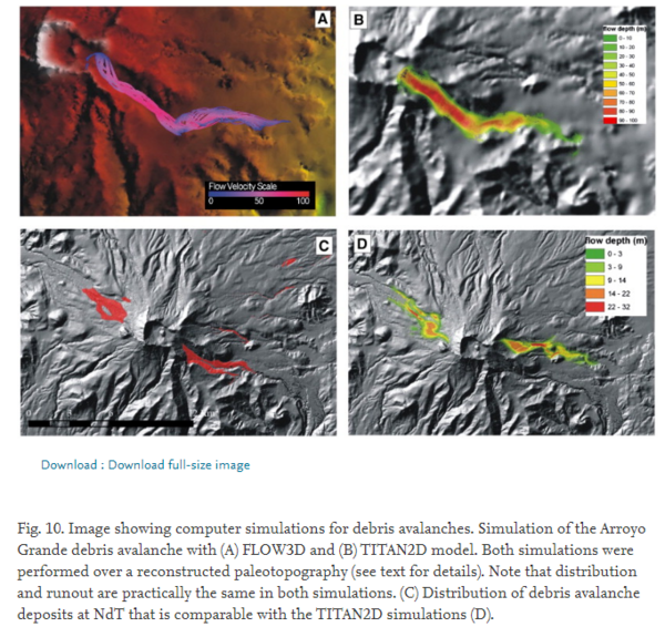
Figure in a journal article
Image showing computer simulations for debris avalanches
Figure 10 in: Capra, L., Norini, G., Groppelli, G., Macías, J.L., & Arce, J.L. (2008). Volcanic hazard zonation of the Nevado de Toluca volcano, México. Journal of Volcanology and Geothermal Research, 176(4), p. 469-484. https://doi.org/10.1016/j.jvolgeores.2008.04.016
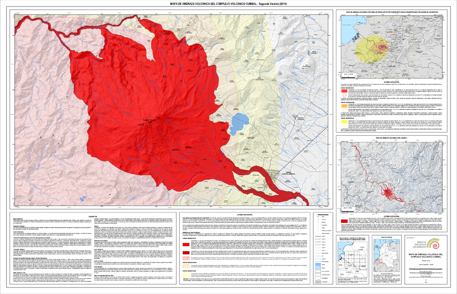
Official, Insert/poster-size map with accompanying report
Mapa de Amenaza Volcánica del Complejo Volcánico Cumbal -- Segunda Versión (2014)
(Volcanic Hazard Map of the Cumbal Volcanic Complex -- Second Version (2014))
Servicio Geológico Colombiano (SGC). (2014). Mapa de Amenaza Volcánica del Complejo Volcánico Cumbal. Segunda Version.
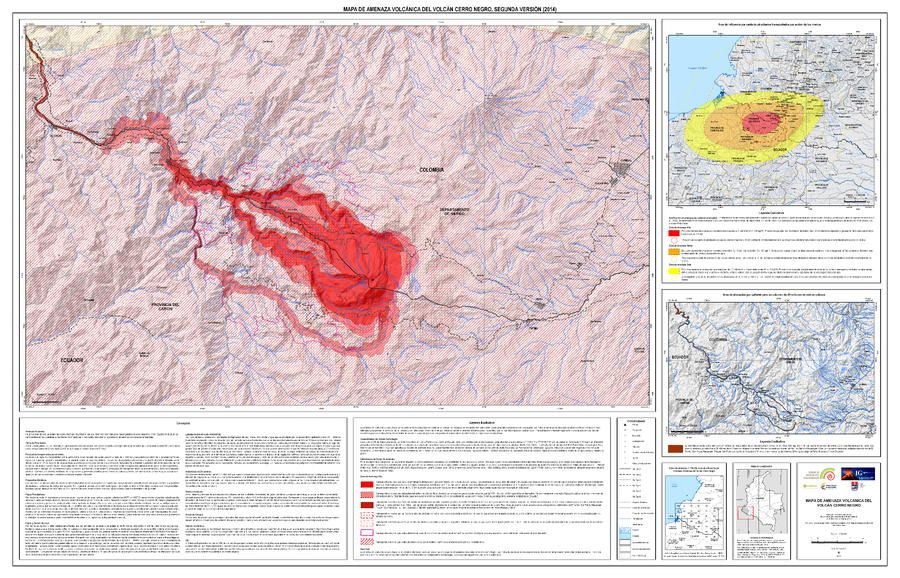
Official, Map sheet or poster
Mapa de Amenaza Volcánica del Volcán Cerro Negro, Segunda Versión (2014)
(Volcanic Hazard Map of Cerro Negro Volcano, Second Version (2014))
Servicio Geológico Colombiano (SGC). (2014). Mapa de Amenaza V olcánica del Volcán Cerro Negro, Segunda Versión. escala 1:50,000.
Official, Map sheet or poster
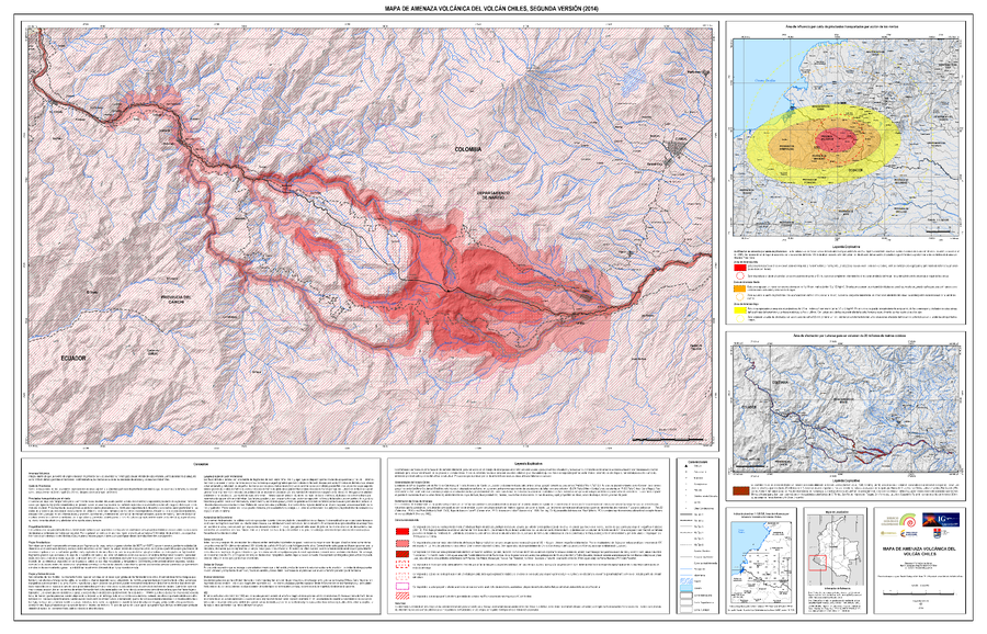
Mapa de Amenaza Volcánica del Volcán Chiles, Segunda Versión (2014)
(Volcanic Hazard Map of Chiles Volcano, Second Edition (2014))
Servicio Geológico Colombiano (SGC). (2014). Mapa de Amenaza Volcánica del Volcán Chiles, Sugunda Versión. escala 1:50,000.
Official, Map sheet or poster
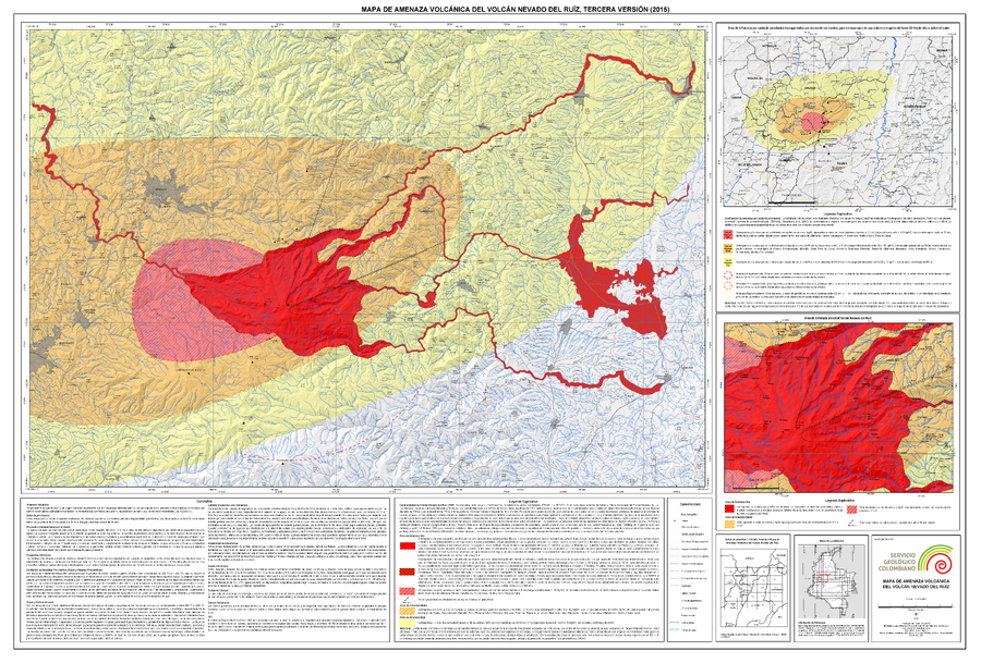
Mapa de Amenaza Volcánica del Volcán Nevado del Ruiz, Tercera Versión (2015)
(Volcanic Hazard Map of Nevado del Ruiz Volcano, Third Version (2015))
Servicio Geológico Colombiano (SGC). (2015). Mapa de Amenaza Volcánica del Volcán Nevado del Ruiz, Tercera Version. mapa escala 1:120,000. Bogota.