
Advanced Search for Maps
Showing 61-70 of 845
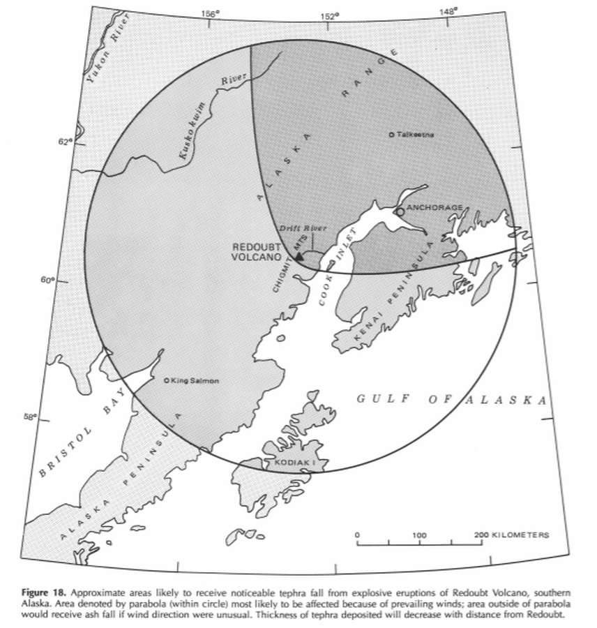
Official, Figure in hazard assessment
Approximate areas likely to receive noticeable tephra fall from explosive eruptions of Redoubt Volcano, southern Alaska
Figure 18 in: Till, A.B., Yount, M.E., & Riehle, J.R. (1993). Redoubt Volcano, southern Alaska; a hazard assessment based on eruptive activity through 1968. U.S. Geological Survey, Bulletin 1996, 19 p., 1 plate. https://doi.org/10.3133/b1996
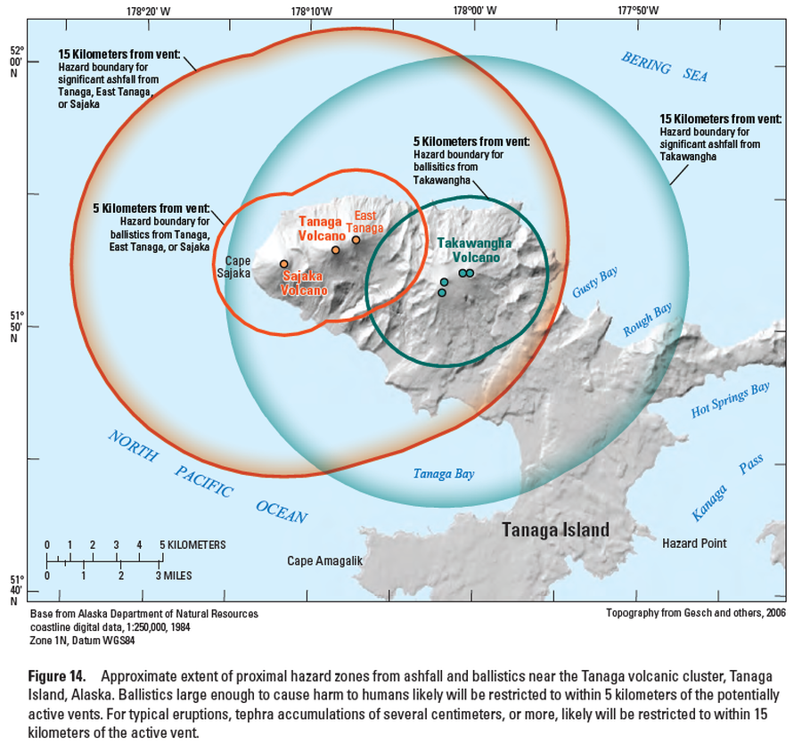
Official, Figure in hazard assessment
Approximate extent of proximal hazard zones from ashfall and ballistics near the Tanaga volcanic cluster, Tanaga Island, Alaska
Figure 14 in: Coombs, M.L., McGimsey, R.G. & Browne, B.L. (2007). Preliminary volcano-hazard assessment for the Tanaga volcanic cluster, Tanaga Island, Alaska. U.S. Geological Survey, Scientific Investigations Report 2007-5094, 41 p., 1 plate. https://doi.org/10.3133/sir20075094
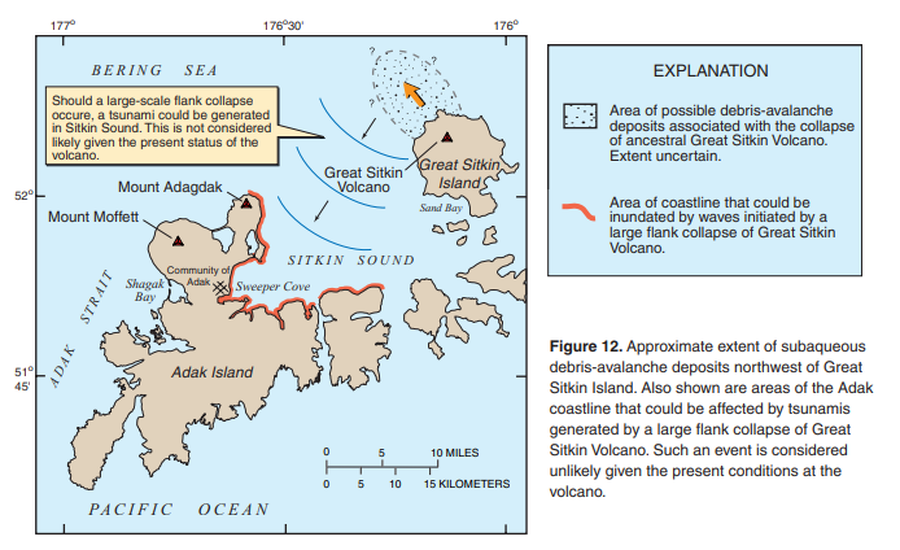
Official, Figure in hazard assessment
Approximate extent of subaqueous debris-avalanche deposits northwest of Great Sitkin Island. Also shown are areas of Adak coastline that could be affected by tsunamis generated by a large flank collapse of Great Sitkin Volcano.
Figure 12 in: Waythomas, C.F., Miller, T.P. & Nye, C.J. (2003). Preliminary volcano-hazard assessment for Great Sitkin Volcano, Alaska. U.S. Geological Survey, Open-File Report 03-112, 25 p., 1 plate. https://doi.org/10.3133/ofr03112

Official, Flyer, brochure, short fact-sheet, or handout
Are You at Risk from the Next Eruption of Mount Hood? Hazards Zonation Map
Gardner, C. A., Scott, W. E., Major, J. J., & Pierson, T. C. (2000). Mount Hood-history and hazards of Oregon's most recently active volcano. US Geological Survey, Fact Sheet 060-00 (PDF Version). https://doi.org/10.3133/fs06000
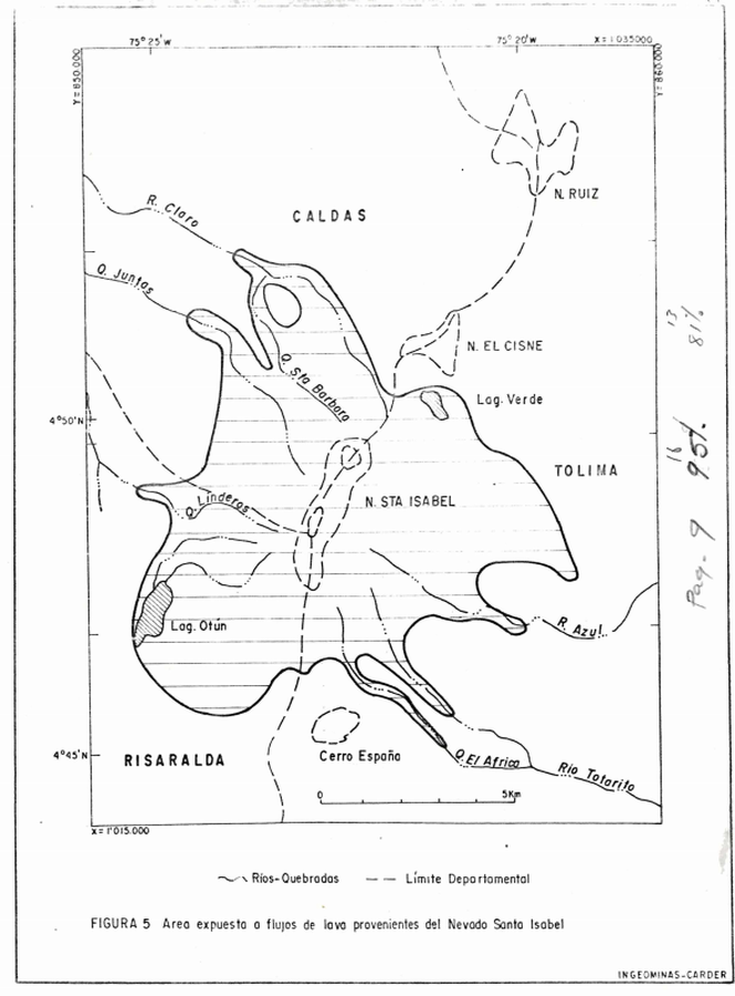
Official, Figure in hazard assessment
Area expuesta a flujos de lava provenientes del Nevado Santa Isabel
(Area exposed to lava flows from Nevado de Santa Isabel)
Figure 5 in: Instituto de Investigaciones en Geociencias, Mineria y Quimica (INGEOMINAS). (1993). Mapa Preliminar de Amenaza Volcanica Potencial Complejo de Domos Santa Isabel, Cordillera Central de Colombia. Ibague.
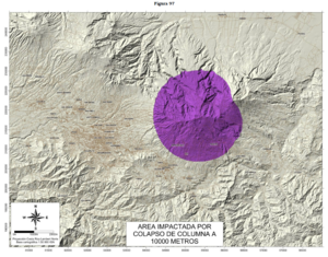
Official, Figure in hazard assessment
Area Impactada por Colapso de Columna a 10000 Metros
(Impacted Area from Column Collapse from 10000 Meters)
Figure 97 in: Soto, G.J. & Sjöbohm, L. (2015). Escenarios de amenaza del volcán Irazú (Costa Rica): Una aproximación preliminar. FUNDEVI, Universidad de Costa Rica, Escuela Centroamericana de Geología. 188 p. https://doi.org/10.13140/RG.2.2.22061.54240
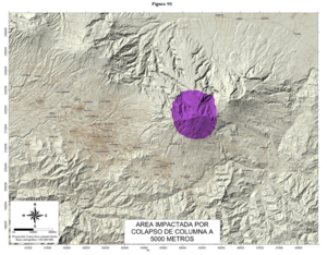
Official, Figure in hazard assessment
Area Impactada por Colapso de Columna a 5000 Metros
(Impacted Area from Column Collapse from 5000 Meters)
Figure 95 in: Soto, G.J. & Sjöbohm, L. (2015). Escenarios de amenaza del volcán Irazú (Costa Rica): Una aproximación preliminar. FUNDEVI, Universidad de Costa Rica, Escuela Centroamericana de Geología. 188 p. https://doi.org/10.13140/RG.2.2.22061.54240
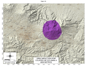
Official, Figure in hazard assessment
Area Impactada por Colapso de Columna a 8000 Metros
(Impacted Area from Column Collapse from 8000 Meters)
Figure 96 in: Soto, G.J. & Sjöbohm, L. (2015). Escenarios de amenaza del volcán Irazú (Costa Rica): Una aproximación preliminar. FUNDEVI, Universidad de Costa Rica, Escuela Centroamericana de Geología. 188 p. https://doi.org/10.13140/RG.2.2.22061.54240
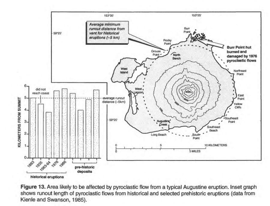
Official, Figure in hazard assessment
Area likely to be affected by pyroclastic flow from a typical Augustine eruption
Figure 13 in: Waythomas, C.F. & Waitt, R. (1998). Preliminary volcano-hazard assessment for Augustine Volcano, Alaska. U.S. Geological Survey, Open-File Report 98-106. https://doi.org/10.3133/ofr98106
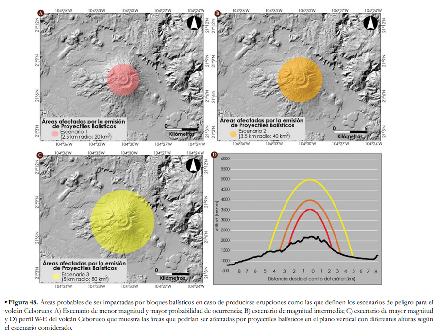
Official, Figure in hazard assessment
Áreas afectadas por la emisión de Proyectiles Balísticos
(Areas affected by the emission of Ballistic Projectiles)
Figure 48 in: Ferrés López, D., Sieron, K., González Zuccolotto, K., Constantinescu, R., Agustín Flores, J., Siebe Grabach, C., Capra Pedol, L., Connor, L., & Connor, C.B. (2019). Memoria técnica del mapa de peligros del volcán Ceboruco (Nayarit). Monografías del Instituto de Geofísica, 24.