
Advanced Search for Maps
Showing 521-528 of 528
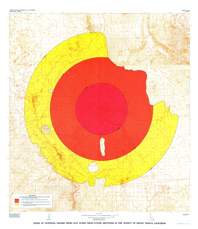
Official, Insert/poster-size map with accompanying report
Zones of Potential Hazard from Lava Flows from Future Eruptions in the Vicinity of Mount Shasta, California
Plate 2 in: Miller, C.D. (1980). Potential hazards from future eruptions in the vicinity of Mount Shasta Volcano, Northern California. U.S. Geological Survey, Bulletin 1503, 43 p., 3 plates. https://doi.org/10.3133/b1503

Official, Insert/poster-size map with accompanying report
Zones of Potential Hazard from Pyroclastic Flows and Associated Ash Clouds and Mudflows that may Result from future eruptions in the vicinity of Mount Shasta, California
Plate 3 in: Miller, C.D. (1980). Potential hazards from future eruptions in the vicinity of Mount Shasta Volcano, Northern California. U.S. Geological Survey, Bulletin 1503, 43 p., 3 plates. https://doi.org/10.3133/b1503
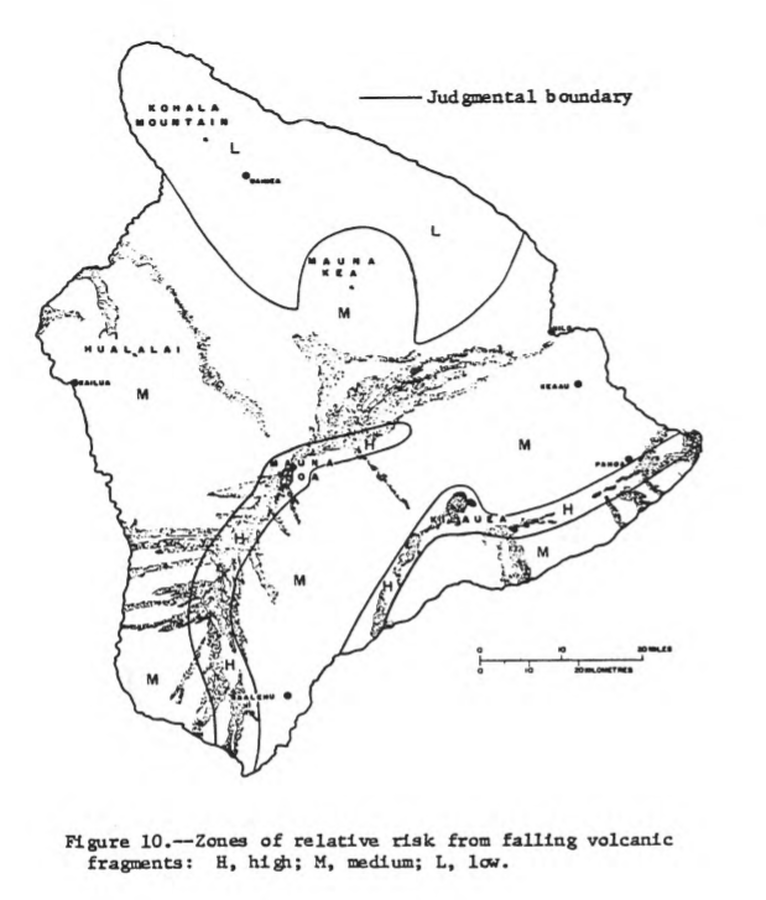
Official, Figure in hazard assessment
Zones of relative risk from falling volcanic fragments
Figure 10 in: Mullineaux, D.R. & Peterson, D.W. (1974). Volcanic hazards on the Island of Hawaii. U.S. Geological Survey, Open-File Report 74-239. https://doi.org/10.3133/ofr74239

Official, Figure in hazard assessment
Zones of relative risk from lava-flow burial
Figure 9 in: Mullineaux, D.R. & Peterson, D.W. (1974). Volcanic hazards on the Island of Hawaii. U.S. Geological Survey, Open-File Report 74-239. https://doi.org/10.3133/ofr74239
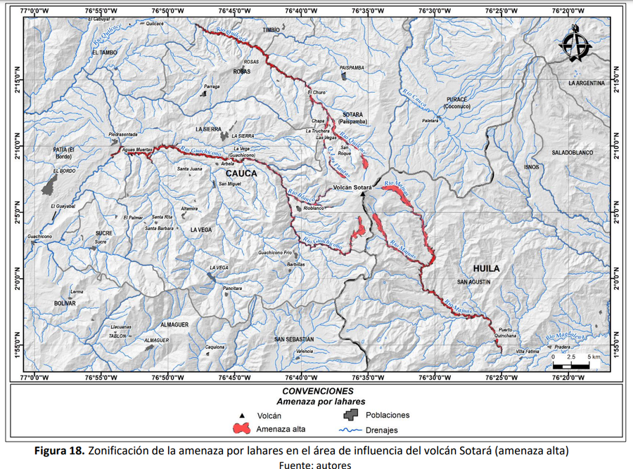
Official, Figure in hazard assessment
Zonificación de la amenaza por lahares en el área de influencia del volcán Sotará (amenaza alta)
(Zoning of the lahar hazard in the area of influence of the Sotará volcano (high hazard))
Figure 18 in: Pulgarín, B., Zuluaga, I., Galarza, J. Muñoz, C. y Laverde, C. (2019). Memoria del mapa de amenaza volcánica del volcán Sotará. Popayán, Pasto y Bogotá: Servicio Geológico Colombiano.
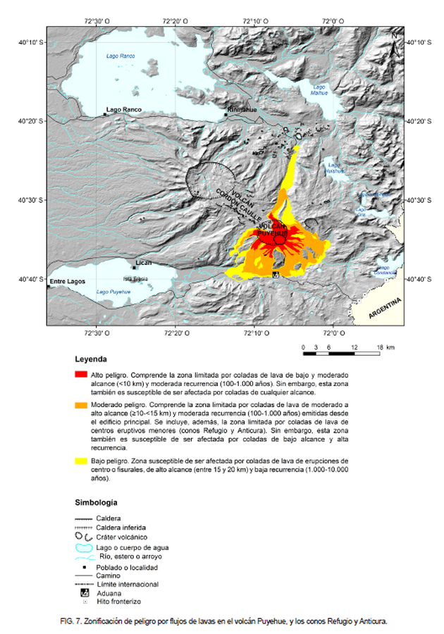
Official, Figure in hazard assessment
Zonificación de peligro por flujos de lavas en el volcán Puyehue, y los conos Refugio y Anticura
(Hazard zoning for lava flows from Puyehue volcano, and the Refugio and Anticura cones)
Figure 7 in: Toloza, V., Jorquera, C., Mella, M., Gho, R. (2020). Peligros del Complejo Volcánico Puyehue-Cordón Caulle, regiones de Los Ríos y Los Lagos. Servicio Nacional de Geología y Minería, Carta Geológica de Chile, Serie Geología Ambiental 36, 63 p., 1 mapa escala 1:75.000. Santiago.
Puyehue-Cordon Caulle, Chile
Official, Figure in hazard assessment
Zonificación de peligro por piroclastos balísticos en el Complejo Volcánico Puyehue-Cordón Caulle
(Hazard zoning for ballistic pyroclastic from the Puyehue-Cordón Caulle Volcanic Complex)
Figure 15 in: Toloza, V., Jorquera, C., Mella, M., Gho, R. (2020). Peligros del Complejo Volcánico Puyehue-Cordón Caulle, regiones de Los Ríos y Los Lagos. Servicio Nacional de Geología y Minería, Carta Geológica de Chile, Serie Geología Ambiental 36, 63 p., 1 mapa escala 1:75.000. Santiago.
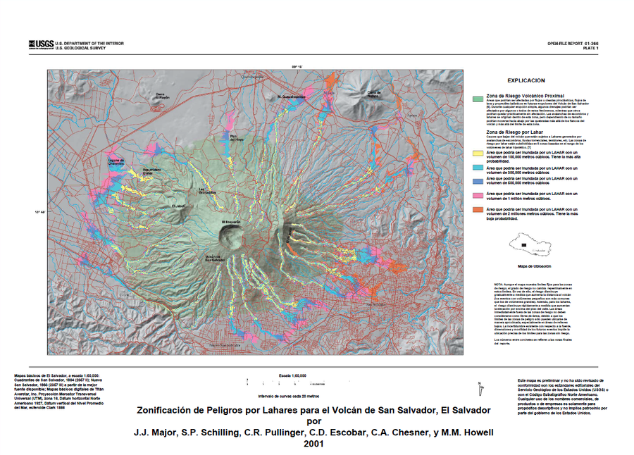
Official (foreign agency), Insert/poster-size map with accompanying report
Zonificación de Peligros por Lahares para el Volcán de San Salvador, El Salvador
(Lahar Hazard Zoning for the San Salvador Volcano, El Salvador)
Plate 1 (Color) in: Major, J.J., Schilling, S.P., Sofield, D.J., Escobar, C.D., & Pullinger, C.R. (2001). Volcano Hazards in the San Salvador Region, El Salvador. U.S. Geological Survey, Open-File Report 2001-366, 24 p., 2 plates. https://doi.org/10.3133/ofr01366