← Back to Search Results

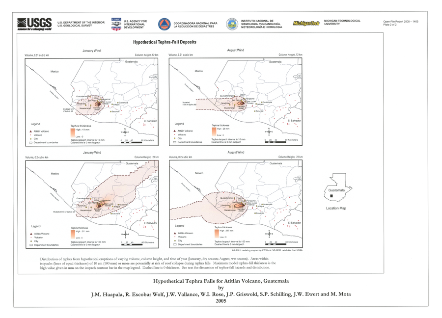
Hypothetical Tephra-fall Deposits

Atitlán, Guatemala, 2005

Plate 2 in: Haapala, J. M., Escobar Wolf, R., Vallance, J. W., Rose, W. I., Griswold, J. P., Schilling, S. P., Ewert, J.W., & Mota, M. (2005). Volcanic hazards at Atitlan volcano, Guatemala. U.S. Geological Survey, Open-File Report, 1403. https://doi.org/10.3133/ofr20051403


This map was produced by an official agency of a foreign government, but may not be the most recent, most complete, or main operational map. For the current operational hazard map, please consult the proper institutional authorities.


Click on image for full-size map. If link seems broken, try the archived version.

Map Set

Haapala, J. M., Escobar Wolf, R., Vallance, J. W., Rose, W. I., Griswold, J. P., Schilling, S. P., Ewert, J.W., & Mota, M. (2005). Volcanic hazards at Atitlan volcano, Guatemala. US Geological Survey, Open-File Report, 1403. https://doi.org/10.3133/ofr20051403
https://doi.org/10.3133/ofr20051403

Other Maps In Set:

Map Data

Map ID1235
Hazard Process(es)Tephra fall
Hazard Zone PresentationSingle hazard: A single hazard process is represented on a series of small map panels of similar sizes
Temporal ScaleBackground, or long-term, map
Spatial ScaleRegional
Publication FormatPoster-style map insert in hazard assessment
Zonation Method(s)Scenario modeling
Zonation Model(s)ASHFALL (Hurst 1994)
Scenario(s) ConsideredSeason or weather; Size, VEI, or intensity
Hazard Zone Label(s)Estimated value or Hazard Impact Metric
Probability Definition(s)Scenarios imply probability
PurposeMultiple: intended for multiple purposes including general hazard awareness, planning, and crisis management
AudienceMultiple audiences (usually the public, civil authorities, and land-use planners)
Language(s)English
Basemap(s)Administrative boundaries (e.g. county, park, intl.)
Basemap overlay(s)
DiemsionalityPlanimetric (2D or map) view
Color SchemeDark to Light (color)
Go to Global Volcanism Program page for Atitlán →