
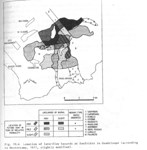
Zonation of lava-flow hazards at Soufrière in Guadeloupe (according to Westercamp, 1977, slightly modified)
Soufrière Guadeloupe, Guadeloupe [France], 1983
Figure 10.4 in: Westercamp, D. (1983). Appraisal and zonation of volcanic hazards in the French Lesser Antilles: preliminary results. In: Tazieff, H. & Sabroux, J.-C. (Eds.) Forecasting Volcanic Events, Elsevier, Amsterdam, p. 111-130.
This hazard map is the result of scientific research and was published in academic literature.
It is presented here to serve as an example of the map type or the map-making methodology. It is NOT the official, operational map. For the current operational hazard map, please consult the proper institutional authorities.
Map Set
- Assessment and zonation of hazards from future lahars of phreatic and collapse-type at Soufrière in Guadeloupe (according to Westercamp, 1981b)
- Zonation of future Merapi-type underflows at Mont Pelée based upon an empirical relation
- Preliminary zonation of future blast effects and associated pyroclastic surges at Mont Pelée
- Preliminary zonation of future Plinian-type air-fall effects at Mont Pelée