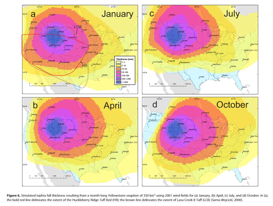
Simulated tephra fall thickness resulting from a month-long Yellowstone eruption of 330 km³ using 2001 wind fields for (a) January, (b) April, (c) July, and (d) October.
Yellowstone, United States, 2014
Figure 6 in: Mastin, L.G., Van Eaton, A.R., & Lowenstern, J.B. (2014). Modeling ash fall distribution from a Yellowstone supereruption. Geochemistry, Geophysics, Geosystems, 15(8), 3459-3475. https://doi.org/10.1002/2014GC005469
This map was produced by an official agency, but may not be the most recent, most complete, or main operational map.
For the current operational hazard map, please consult the proper institutional authorities.

Click on image for full-size map.
Map Set
Mastin, L. G., Van Eaton, A. R., & Lowenstern, J. B. (2014). Modeling ash fall distribution from a Yellowstone supereruption. Geochemistry, Geophysics, Geosystems, 15(8), 3459-3475. https://doi.org/10.1002/2014GC005469
https://doi.org/10.1002/2014GC005469
Other Maps In Set:
- Simulated tephra fall thickness resulting from a week-long Yellowstone eruption of 330 km³ using 2001 wind fields for (a) 21–27 January, (b) 21–27 April, 21–27 July, and(d) 21–27 October.
- Simulated tephra fall thickness resulting from a 3-day-long Yellowstone eruption of 330 km³ using 2001 wind fields for (a) 14–16 January, (b) 14–16 April, (c) 14–16 July, and(d) 14–16 October.
- Results of simulations with no umbrella cloud: (a) 1 month (January); 1 week(21–27 January); and 3 days (14–16 January
- Tephra fall thickness for simulations from 21 to 27 April, using (a) a 15 km umbrella-cloud height, (b) a 35 km umbrella-cloud height, (c) grain-size distribution GSD2, and(d) grain-size distribution GSD3.
Map Data
Map ID 1457 Hazard Process(es) Tephra fall Hazard Zone Presentation Single hazard: A single hazard process is represented on a series of small map panels of similar sizes Temporal Scale Crisis, or short-term, map (hours to decades) Spatial Scale Regional Publication Format Figure in a journal article Zonation Method(s) Scenario modeling Zonation Model(s) ASH3D (Schwaiger et al. 2012; Mastin et al. 2013) Scenario(s) Considered Duration or timing; Season or weather; Size, VEI, or intensity Hazard Zone Label(s) Estimated value or Hazard Impact Metric Probability Definition(s) No probability definition was discernable from the map Purpose Scientific interest: Intended for scientific research and general scientific interest; usually published in academic journals Audience Scientists (usually in scientific publication) Language(s) English Basemap(s) Administrative boundaries (e.g. county, park, intl.) Basemap overlay(s) Diemsionality Planimetric (2D or map) view Color Scheme Purple to Yellow
