← Back to Search Results

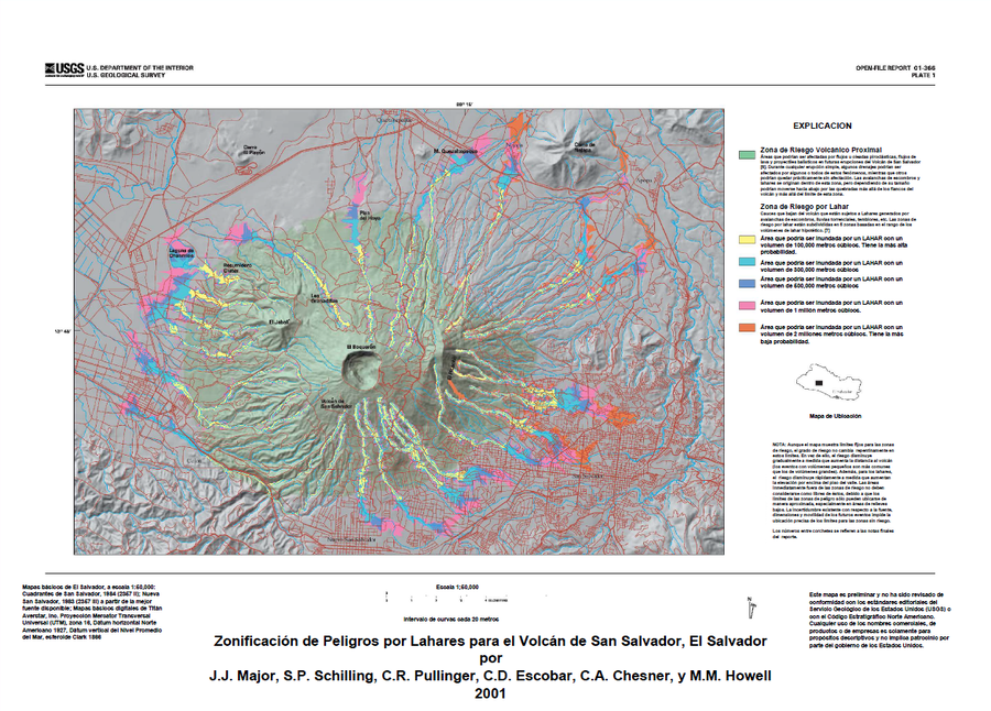
Zonificación de Peligros por Lahares para el Volcán de San Salvador, El Salvador

Lahar Hazard Zoning for the San Salvador Volcano, El Salvador

San Salvador, El Salvador, 2001

Plate 1 (Color) in: Major, J.J., Schilling, S.P., Sofield, D.J., Escobar, C.D., & Pullinger, C.R. (2001). Volcano Hazards in the San Salvador Region, El Salvador. U.S. Geological Survey, Open-File Report 2001-366, 24 p., 2 plates. https://doi.org/10.3133/ofr01366


This map was produced by an official agency of a foreign government, but may not be the most recent, most complete, or main operational map. For the current operational hazard map, please consult the proper institutional authorities.


Click on image for full-size map. If link seems broken, try the archived version.

Map Set

Major, J.J., Schilling, S.P., Sofield, D.J., Escobar, C.D., & Pullinger, C.R. (2001). Volcano Hazards in the San Salvador Region, El Salvador. U.S. Geological Survey, Open-File Report 2001-366, 24 p., 2 plates. https://doi.org/10.3133/ofr01366
https://doi.org/10.3133/ofr01366

Other Maps In Set:

Map Data

Map ID3342
Hazard Process(es)Ballistics; Lahars; Lava flows; PDCs; Proximal hazards; Surges
Hazard Zone PresentationGrouped by location (e.g. proximal/distal zones) on a main map panel
Temporal ScaleBackground, or long-term, map
Spatial ScaleVolcano and surrounding area
Publication FormatPoster-style map insert in hazard assessment
Zonation Method(s)Scenario modeling
Zonation Model(s)Energy cone or line (Heim 1932; Sheridan 1979; Sheridan & Malin 1983); LAHARZ or modified version (such as PFZ) (Iverson et al. 1998; Schilling 1998; Schilling 2014)
Scenario(s) ConsideredSize, VEI, or intensity; Source location or direction
Hazard Zone Label(s)Location or source name; Scenario name
Probability Definition(s)Qualitative relative probability (e.g. high-medium-low)
PurposeMultiple: intended for multiple purposes including general hazard awareness, planning, and crisis management
AudienceMultiple audiences (usually the public, civil authorities, and land-use planners)
Language(s)Spanish
Basemap(s)Hillshade
Basemap overlay(s)Contour lines; Street map
DiemsionalityPlanimetric (2D or map) view
Color SchemeCategorical/Qualitative
Go to Global Volcanism Program page for San Salvador →