
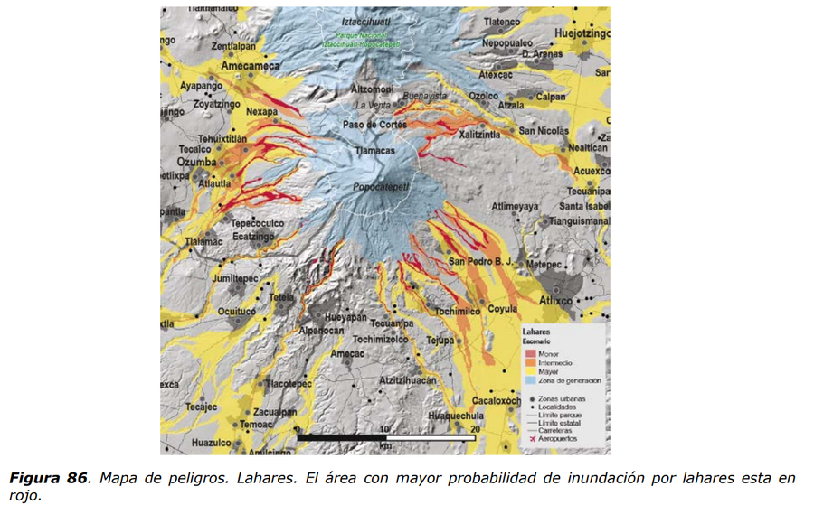
Mapa de peligros. Lahares. El área con mayor probabilidad de inundación por lahares esta en rojo.
Hazard map. Lahars. The area most likely to be inundated by lahars is in red.
Popocatépetl, Mexico, 2017
Figure 86 in: Martin Del Pozzo, A.L, Alatorre Ibargüengoitia M., Arana Salinas L., Bonasia R., Capra Pedol L., Cassata W., Cordoba G., Cortés Ramos J., Delgado Granados H., Ferrés López M.D., Fonseca Álvarez R., García Reynoso J.A., Gisbert G., Guerrero López D.A., Jaimes Viera M., Macías Vázquez J.L., Nieto Obregon J., Nieto Torres A., Paredes Ruiz P.A., Portocarrero Martínez J., Renne P., Rodríguez Espinosa D.M., Salinas Sánchez S., Siebe Grabach C., & Tellez Ugalde E. (2017). Estudios geológicos y actualización del mapa de peligros del volcán Popocatépetl. Memoria técnica del mapa de peligros del volcán Popocatépetl. Instituto de Geofísica, Universidad Nacional Autónoma de México (UNAM).
This map was produced by an official agency, but may not be the most recent, most complete, or main operational map.
For the current operational hazard map, please consult the proper institutional authorities.
Click on image for full-size map. If link seems broken, try the archived version.
Martin Del Pozzo, A.L, Alatorre lbargüengoitia M., Arana Salinas L., Bonasia R., Capra Pedol L., Cassata W., Cordoba G., Cortés Ramos J., Delgado Granados H., Ferrés López M.D., Fonseca Álvarez R., García Reynoso J.A., Gisbert G., Guerrero López D.A., Jaimes Viera M., Macías Vázquez J.L., Nieto Obregon J., Nieto Torres A., Paredes Ruiz P.A., Portocarrero Martínez J., Renne P., Rodríguez Espinosa D.M., Salinas Sánchez S., Siebe Grabach C., & Tellez Ugalde E. (2016). Mapas de Peligros del Volcán Popocatépetl. Instituto de Geofísica, Universidad Nacional Autónoma de México (UNAM), CENEPRED, SEGOB.Map Set
https://www.geofisica.unam.mx/assets/monografias22.pdf
Other Maps In Set:
Map Data
Map ID 3433 Hazard Process(es) Lahars; Proximal hazards Hazard Zone Presentation Single hazard: A single hazard process is represented on a main map panel Temporal Scale Background, or long-term, map Spatial Scale Volcano and surrounding area Publication Format Figure in a hazard assessment or mitigation plan Zonation Method(s) Scenario modeling Zonation Model(s) FLO-2D (O'Brien 1993); LAHARZ or modified version (such as PFZ) (Iverson et al. 1998; Schilling 1998; Schilling 2014) Scenario(s) Considered Size, VEI, or intensity; Source location or direction Hazard Zone Label(s) Hazard process name; Qualitative relative probability (e.g. high-medium-low) Probability Definition(s) Qualitative relative probability (e.g. high-medium-low) Purpose Multiple: intended for multiple purposes including general hazard awareness, planning, and crisis management Audience Multiple audiences (usually the public, civil authorities, and land-use planners) Language(s) Spanish Basemap(s) Hillshade Basemap overlay(s) Street map Diemsionality Planimetric (2D or map) view Color Scheme Red to Yellow