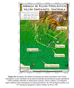
Amenaza de Flujos Piroclásticos Volcán Santiaguito, Guatemala
Threat of Pyroclastic Flows Santiaguito Volcano, Guatemala
Santiaguito (Santa María), Guatemala, 2003
Figure 26 in: UNESCO, Instituto Nacional de Sismología, Vulcanología, Meteorología e Hidrología (INSIVUMEH), Coordinadora Nacional para la Reducción de Desastres (CONRED), Instituto Geográfico Nacional (IGN), Facultad de Agronomía (FAUSAC), Universidad de San Carlos de Guatemala Centro de Estudios Superiores de Energía y Minas (CESEM), Universidad de San Carlos de Guatemala, Escuela Regional de Ingeniería Sanitaria (ERIS). (2003). Zonificación de Amenazas Naturales en la cuenca del río Samalá y Análisis de vulnerabilidad y riesgo en la población de San Sebastián Retalhuleu, Guatemala, Centro América. Capacity Building for Natural Disaster Reduction (CBNDR) Regional Action Program for Central America (RAPCA). Guatemala, Septiembre 2003.
This map was produced by an official agency, but is NOT the most recent, most complete, or main operational map.
For the current operational hazard map, please consult the proper institutional authorities.

Click on thumbnail for full-size map. We do not have copyright permission to display the full-size image. If you are the copyright holder and wish to provide copyright, please contact us at admin@volcanichazardmaps.org. If link seems broken, try the archived version.
