← Back to Search Results

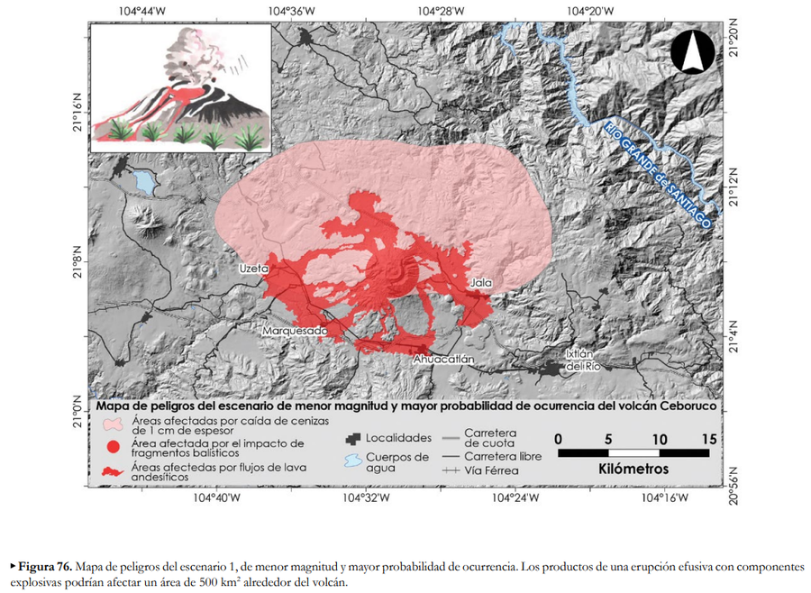
Mapa de peligros del escenario de menor magnitud y mayor probabilidad de ocurrencia del volcán Ceboruco

Hazard map of the scenario of lower magnitude and greater probability of occurrence for Ceboruco volcano

Ceboruco, Mexico, 2019

Figure 76 in: Ferrés López, D., Sieron, K., González Zuccolotto, K., Constantinescu, R., Agustín Flores, J., Siebe Grabach, C., Capra Pedol, L., Connor, L., & Connor, C.B. (2019). Memoria técnica del mapa de peligros del volcán Ceboruco (Nayarit). Monografías del Instituto de Geofísica, 24.


This map was produced by an official agency, but may not be the most recent, most complete, or main operational map. For the current operational hazard map, please consult the proper institutional authorities.


Click on image for full-size map. If link seems broken, try the archived version.

Map Set

Ferrés Lopez, D., Sieron, K., González Zuccolotto, K., Constantinescu, R., Agustín Flores, J., Siebe, C., Capra, L., Connor, L., & Connor, C.B. (2019). Memoria técnica del mapa de peligros del volcán Ceboruco (Nayarit). Monografías del Instituto de Geofísica, 24.
https://www.geofisica.unam.mx/recursos/docs/editorial/IGEF_monografias_24.pdf

Other Maps In Set:

Map Data

Map ID3799
Hazard Process(es)Ballistics; Lava flows; Tephra fall
Hazard Zone PresentationHazard process-focused: Most hazard processes are separated by hazard process type on a main map panel
Temporal ScaleBackground, or long-term, map
Spatial ScaleVolcano and surrounding area
Publication FormatFigure in a hazard assessment or mitigation plan
Zonation Method(s)Probabilistic modeling; Scenario modeling
Zonation Model(s)Eject! (Mastin 2001); Etna Lava Flow Model (Damiani et al. 2006); HAZMAP (Macedonio et al. 2005)
Scenario(s) ConsideredComposition; Season or weather; Size, VEI, or intensity; Source location or direction; Style or type
Hazard Zone Label(s)Estimated value or Hazard Impact Metric; Hazard process name
Probability Definition(s)Qualitative relative probability (e.g. high-medium-low)
PurposeMultiple: intended for multiple purposes including general hazard awareness, planning, and crisis management
AudienceMultiple audiences (usually the public, civil authorities, and land-use planners)
Language(s)Spanish
Basemap(s)Hillshade
Basemap overlay(s)Street map
DiemsionalityPlanimetric (2D or map) view
Color SchemeDark to Light (color)
Go to Global Volcanism Program page for Ceboruco →