
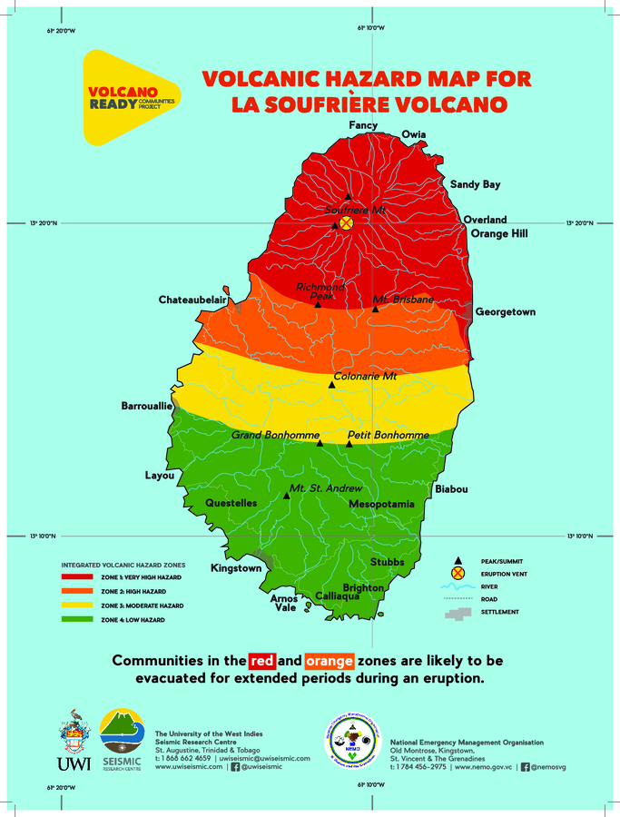
Volcanic Hazard Map for La Soufrière Volcano
Soufrière St. Vincent, Saint Vincent and the Grenadines, 2021
The University of the West Indies Seismic Research Centre (UWI-SRC) and National Emergency Management Organization (NEMO). (2021). Volcanic Hazard Map for La Soufrière Volcano. https://uwiseismic.com/wp-content/uploads/2021/10/SoufriereEruption-SVGHazMap.pdf. (Modified from: Robertson et al. 2005)
This map was produced by an official agency, but may not be the most recent, most complete, or main operational map.
For the current operational hazard map, please consult the proper institutional authorities.
Click on thumbnail for full-size map. We do not have copyright permission to display the full-size image. If you are the copyright holder and wish to provide copyright, please contact us at admin@volcanichazardmaps.org. If link seems broken, try the archived version.
The University of the West Indies Seismic Research Centre (UWI-SRC). La Soufriѐre Eruption 2020-2021. https://uwiseismic.com/volcanoes/la-soufriere-eruption-2020-2021-hub/Map Set
https://uwiseismic.com/volcanoes/la-soufriere-eruption-2020-2021-hub/?fbclid=IwAR3nnf9BtLIW6pvrxhcoW-BGUs9Y-KvYyQu8kWCwUwvakQSesH9r4Ln8Uhw
Other Maps In Set: