
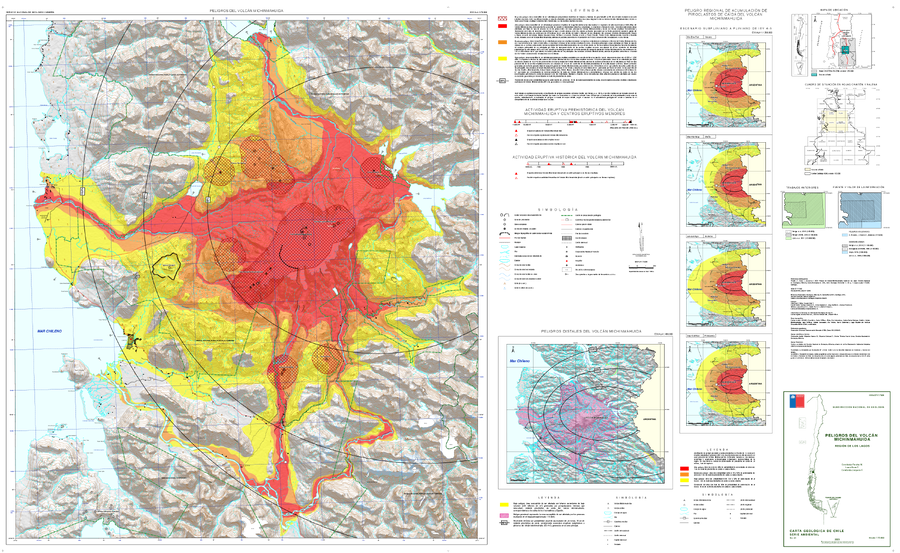
Peligros del Volcán Michinmahuida, región de Los Lagos
Dangers of Michinmahuida Volcano, Los Lagos region
Michinmahuida, Chile, 2023
Perales, C., Bono, L., Jorquera, C. (2023). Peligros del Volcán Michinmahuida, región de Los Lagos. Servicio Nacional de Geología y Minería, Carta Geológica de Chile, Serie Geología Am biental 41: 90 p., 1 m apa escala 1:75.000. Santiago.
This map was produced by an official agency, but may not be the most recent, most complete, or main operational map.
For the current operational hazard map, please consult the proper institutional authorities.
Click on image for full-size map.
Map Set
Perales, C., Bono, L., Jorquera, C. (2023). Peligros del Volcán Michinmahuida, región de Los Lagos. Servicio Nacional de Geología y Minería, Carta Geológica de Chile, Serie Geología Am biental 41: 90 p., 1 m apa escala 1:75.000. Santiago.
https://repositorio.sernageomin.cl/handle/0104/26221
Other Maps In Set:
- Mapa de susceptibilidad volcánica, que indica la probabilidad espacial de hospedar un nuevo centro de emisión en el futuro
- Zonificación de peligro por flujos de lava, asociados a erupciones efusivas del Volcán Michinmahuida y los centros eruptivos menores
- Zonificación de peligro por corrientes de densidad piroclásticas generadas en el Volcán Michinmahuida
- Zonificación de peligro por lahares primarios asociados al Volcán Michinmahuida
- Zonificación de peligro por lahares secundarios asociados al Volcán Michinmahuida
- Zonificación de peligro por impacto de piroclastos de proyección balística emitidos desde el Volcán Michinmahuida, los centros eruptivos menores y 3 potenciales centros de emisión futuros (A, B y C) al sur del río Rayas
- Zonificación de peligro asociado a la acumulación de 1 cm de material piroclástico de caída y curva de isoprobabilidad (50%) de acumulación de 10 cm de piroclastos de caída provenientes del Volcán Michinmahuida, considerando una erupción vulcaniana (IEV 2-4)
- Zonificación de peligro asociado a la acumulación de 1 cm de material piroclástico de caída y curvas de isoprobabilidad de 10 cm de acumulación de piroclastos de caída provenientes del Volcán Michinmahuida y los centros eruptivos menores, considerando una erupción estromboliana (IEV 1-2)