← Back to Search Results

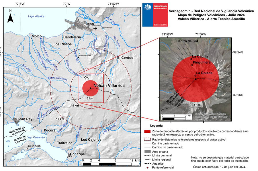
SERNAGEOMIN - Red Nacional de Vigilancia Volcánica - Mapa de Peligros Volcánicos - Julio 2024 - Volcán Villarrica, Alerta Técnica Amarilla

SERNAGEOMIN - National Network of Volcanic Surveillance - Map of Volcanic Hazards - July 2024 - Villarrica Volcano - Yellow Technical Alert

Villarrica, Chile, 2024

Servicio Nacional de Geología y Minería (SERNAGEOMIN) Observatorio Volcanológico de los Andes del Sur (OVDAS). (2024). Reporte Especial de Actividad Volcánica (REAV), Región de la Araucanía y Los Ríos, Volcán Villarrica, 12 de julio de 2024, 11:30 Hora local (Chile continental).


This map was produced by an official agency, but is NOT the most recent, most complete, or main operational map. For the current operational hazard map, please consult the proper institutional authorities.


Click on image for full-size map. If link seems broken, try the archived version.

Map Data

Map ID4244
Hazard Process(es)Unstated or all hazards
Hazard Zone PresentationHazard level-focused: All or most hazards are combined by hazard level on a main map panel
Temporal ScaleVery short-term crisis map (hours to days)
Spatial ScaleVolcano and surrounding area
Publication FormatPart of an information statement, bulletin, or other alert product
Zonation Method(s)Unknown
Zonation Model(s)
Scenario(s) ConsideredCurrent conditions
Hazard Zone Label(s)Qualitative relative probability (e.g. high-medium-low)
Probability Definition(s)Qualitative relative probability (e.g. high-medium-low)
PurposeCrisis management and response: Intended to be used for managing, responding to, and taking action during an eruption; often includes evacuation routes, access restrictions, actions to take, etc.
AudienceMultiple audiences (usually the public, civil authorities, and land-use planners)
Language(s)Spanish
Basemap(s)Hillshade
Basemap overlay(s)Inhabited areas; Photograph; Street map
DiemsionalityPlanimetric (2D or map) view
Color SchemeSingle color
Volcanic Alert Level System
Go to Global Volcanism Program page for Villarrica →