Volcanic hazard maps for Sao Miguel, Azores
São Miguel (Agua de Pau, Furnas, & Sete Cidades), Sao Miguel, Azores [Portugal], 1979
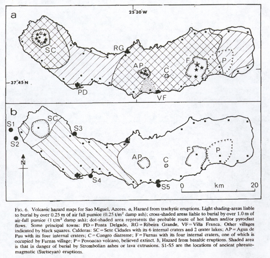
Figure 6 in: Booth, B. (1979). Assessing volcanic risk. Journal of the Geological Society, 136(3), 331-340.
This hazard map is the result of scientific research and was published in academic literature.
It is presented here to serve as an example of the map type or the map-making methodology. It is NOT the official, operational map. For the current operational hazard map, please consult the proper institutional authorities.

Map Set
Booth, B. (1979). Assessing volcanic risk. Journal of the Geological Society, 136(3), 331-340.
https://doi.org/10.1144/gsjgs.136.3.0331
Other Maps In Set:
Map Data
Map ID 4271 Hazard Process(es) Lahars; Lava flows; PDCs; Tephra fall Hazard Zone Presentation Hazard process-focused: Most hazard processes are separated by hazard process type on a series of small map panels of similar sizes Temporal Scale Background, or long-term, map Spatial Scale Island Publication Format Figure in a journal article Zonation Method(s) Geologic history Zonation Model(s) Scenario(s) Considered Composition; Style or type Hazard Zone Label(s) Estimated value or Hazard Impact Metric; Hazard process name Probability Definition(s) No probability definition was discernable from the map Purpose Scientific interest: Intended for scientific research and general scientific interest; usually published in academic journals Audience Scientists (usually in scientific publication) Language(s) English Basemap(s) Simple or sketch map Basemap overlay(s) Diemsionality Planimetric (2D or map) view Color Scheme Symbols and/or lines only