
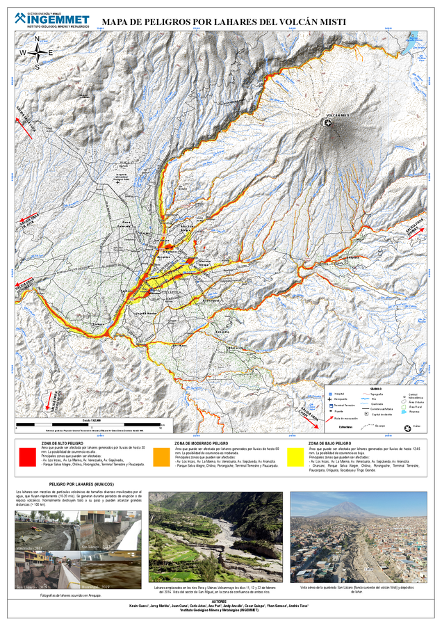
Mapa de Peligros por Lahares del Volcán Misti
Lahar Hazard Map of El Misti Volcano
El Misti, Peru, 2025
Cueva, K., Mariño, J., Cuno, J., Arias, C., Pari, A., Ancalle, A., Quispe, C., Soncco, Y., Ticse, A. (2025). Mapa de Peligros por Lahares del Volcán Misti. Instituto Geológico Minero y Metalúrgico (INGEMMET). https://hdl.handle.net/20.500.12544/5309
This map was produced by an official agency, but is NOT the most recent, most complete, or main operational map.
For the current operational hazard map, please consult the proper institutional authorities.
Click on thumbnail for full-size map. We do not have copyright permission to display the full-size image. If you are the copyright holder and wish to provide copyright, please contact us at admin@volcanichazardmaps.org. If link seems broken, try the archived version.
Cueva, K. & Mariño, J. (2025). Geología y nuevos mapas de peligros del volcán Misti. Lima: Instituto Geológico, Minero y Metalúrgico, 192 p. INGEMMET, Boletín Serie C: Geodinámica e Ingeniería Geológica, 100.
https://hdl.handle.net/20.500.12544/5309Map Set
https://hdl.handle.net/20.500.12544/5309
Other Maps In Set: