
Map of areas not recommended not to enter or camp at Risk Management Stage B - VAL 1
Ruapehu, New Zealand, 2020
Department of Conservation. (2020). Map of areas not recommended not to enter or camp at Risk Management Stage B - VAL 1.
This map was produced by an official agency, but may not be the most recent, most complete, or main operational map.
For the current operational hazard map, please consult the proper institutional authorities.
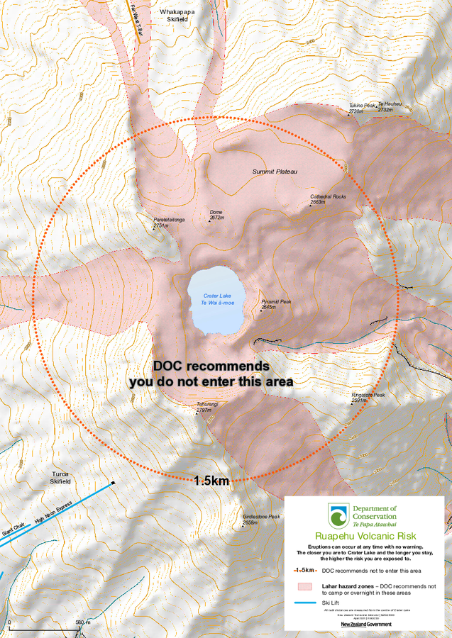
Click on image for full-size map.
Map Set
Department of Conservation. Volcanic risk in Tongariro National Park. https://www.doc.govt.nz/parks-and-recreation/places-to-go/central-north-island/places/tongariro-national-park/know-before-you-go/volcanic-risk-in-tongariro-national-park/
https://www.doc.govt.nz/parks-and-recreation/places-to-go/central-north-island/places/tongariro-national-park/know-before-you-go/volcanic-risk-in-tongariro-national-park/
Other Maps In Set:
- Lahar Warning Whakapapa Village
- Volcanic Hazards on Mt Tongariro
- Volcanic Hazards on Mt. Ruapehu - VAL 2
- Map of areas not recommended not to enter or camp at Risk Management Stage A - VAL 1
- Ruapehu Hazard Zone Map at Risk Management Stage A - VAL 1
- Volcanic Hazards at Whakapapa Mt. Ruapehu
- Volcanic Hazards at Tūroa Mt. Ruapehu
- Volcanic Hazards on and around Mt. Ruapehu - VAL 2
Map Data
Map ID 4334 Hazard Process(es) Access or danger zone; Lahars Hazard Zone Presentation Hazard level- and process-focused: Hazards are both combined by hazard level and separated by hazard process type on a main map panel Temporal Scale Crisis, or short-term, map (hours to decades) Spatial Scale Summit Publication Format Sign or billboard Zonation Method(s) Geologic history Zonation Model(s) Scenario(s) Considered Current conditions Hazard Zone Label(s) Access (exclusion, danger, or safe zones); Hazard process name Probability Definition(s) No probability definition was discernable from the map Purpose Crisis management and response: Intended to be used for managing, responding to, and taking action during an eruption; often includes evacuation routes, access restrictions, actions to take, etc. Audience Tourists or visitors (often for national parks or hiking trails) Language(s) English Basemap(s) Hillshade Basemap overlay(s) Contour lines; Trail or hiking map Diemsionality Planimetric (2D or map) view Color Scheme Single color Volcanic Alert Level System https://global-valid.org/val-newzealand-24/