
Soufriere Hills Volcano, Monsterrat. Hazards Level System. Version 3, 1 August 2014
Soufrière Hills, Montserrat [United Kingdom], 2014
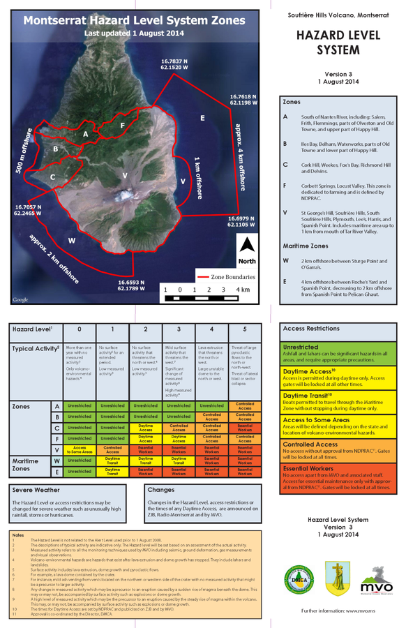
Montserrat Volcano Observatory (MVO). (2014). Soufrière Hills Volcano, Monsterrat. Hazard Level System. Version 3, 1 August 2014. http://www.mvo.ms/pub/Hazard_Level_System/HLS-20140801.pdf
This map was produced by an official agency, but may not be the most recent, most complete, or main operational map.
For the current operational hazard map, please consult the proper institutional authorities.
Click on image for full-size map. If link seems broken, try the archived version.
Map Data
Map ID 462 Hazard Process(es) Access or danger zone Hazard Zone Presentation Hazard level-focused: All or most hazards are combined by hazard level on a main map panel Temporal Scale Crisis, or short-term, map (hours to decades) Spatial Scale Island Publication Format Map on website Zonation Method(s) Expert elicitation Zonation Model(s) Scenario(s) Considered No scenarios were discernable from the map Hazard Zone Label(s) Access (exclusion, danger, or safe zones) Probability Definition(s) No probability definition was discernable from the map Purpose Multiple: intended for multiple purposes including general hazard awareness, planning, and crisis management Audience Multiple audiences (usually the public, civil authorities, and land-use planners) Language(s) English Basemap(s) Satellite image Basemap overlay(s) Diemsionality Planimetric (2D or map) view Color Scheme Symbols and/or lines only Volcanic Alert Level System https://global-valid.org/val-montserrat-42