← Back to Search Results

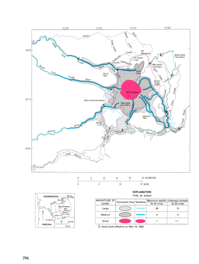
Volcanic-hazards zones, originally drawn on USFS map (approximately 1/2 in. = 1 mi), April 1, 1980.

St. Helens, United States, 1980

Figure 454 in: Miller, C.D., Mullineaux, D.R. & Crandell, D.R. (1981). Hazards assessments at Mount St. Helens. In: Lipman, P. W. & Mullineaux, D. R. (Eds.) The 1980 eruptions of Mount St. Helens, Washington. U.S. Geological Survey, Professional Paper 1250, p. 789-802. https://doi.org/10.3133/pp1250


This map was produced by an official agency, but is NOT the most recent, most complete, or main operational map. For the current operational hazard map, please consult the proper institutional authorities.


Click on image for full-size map. If link seems broken, try the archived version.

Map Set

Miller, C.D., Mullineaux, D.R. & Crandell, D.R. (1981). Hazards assessments at Mount St. Helens. In: Lipman, P. W. & Mullineaux, D. R. (Eds.) The 1980 eruptions of Mount St. Helens, Washington. U.S. Geological Survey, Professional Paper 1250, p. 789-802. https://doi.org/10.3133/pp1250
https://doi.org/10.3133/pp1250

Other Maps In Set:

Map Data

Map ID633
Hazard Process(es)Lahars; PDCs; Tephra fall
Hazard Zone PresentationHazard process-focused: Most hazard processes are separated by hazard process type on a main map and series of insets
Temporal ScaleCrisis, or short-term, map (hours to decades)
Spatial ScaleVolcano and surrounding area
Publication FormatMap sheet or poster
Zonation Method(s)Geologic history
Zonation Model(s)
Scenario(s) ConsideredSize, VEI, or intensity
Hazard Zone Label(s)Scenario name
Probability Definition(s)Scenarios imply probability
PurposeCrisis management and response: Intended to be used for managing, responding to, and taking action during an eruption; often includes evacuation routes, access restrictions, actions to take, etc.
AudienceMultiple audiences (usually the public, civil authorities, and land-use planners)
Language(s)English
Basemap(s)Simple or sketch map
Basemap overlay(s)Street map
DiemsionalityPlanimetric (2D or map) view
Color SchemeCategorical/Qualitative
Go to Global Volcanism Program page for St. Helens →