← Back to Search Results

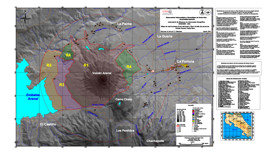
Mapa de restricciones al uso del suelo y libre transito de personas, Volcán Arenal, Costa Rica

Map of restrictions on land use and free movement of people, Arenal Volcano, Costa Rica

Arenal, Costa Rica, 2003

Berrocal, M., Malavassi, E. (2003). Mapa de restricciones al uso del suelo y libre transito de personas Volcan Arenal, Costa Rica. Observatorio Vulcanologico y Sismologico de Costa Rica Universidad Nacional, Laboratorio de Sistemas de Informacion Geografica (OVSICORI - UNA), mapa escala 1:25,000


This map was produced by an official agency, but may not be the most recent, most complete, or main operational map. For the current operational hazard map, please consult the proper institutional authorities.


Click on image for full-size map. If link seems broken, try the archived version.

Map Data

Map ID823
Hazard Process(es)Access or danger zone; Lava flows; PDCs
Hazard Zone PresentationHazard level-focused: All or most hazards are combined by hazard level on a main map panel
Temporal ScaleBackground, or long-term, map
Spatial ScaleVolcano and surrounding area
Publication FormatMap sheet or poster
Zonation Method(s)Geologic history
Zonation Model(s)
Scenario(s) ConsideredNo scenarios were discernable from the map
Hazard Zone Label(s)Access (exclusion, danger, or safe zones); Hazard process name
Probability Definition(s)No probability definition was discernable from the map
PurposeLand-use planning: Intended to inform citing of facilities, building restrictions, resource management, and infrastructure development
AudienceLand-use planners, city planners, government officials, etc.
Language(s)Spanish
Basemap(s)Triangulated irregular network (TIN)
Basemap overlay(s)Infrastructure map; Street map
DiemsionalityPlanimetric (2D or map) view
Color SchemeRed to Green
Go to Global Volcanism Program page for Arenal →