
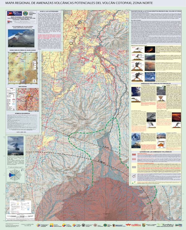
Mapa Regional de Amenazas Volcánicas Potenciales del Volcán Cotopaxi, Zona Norte
Regional Map of Potential Volcanic Hazards of Cotopaxi Volcano, North Zone
Cotopaxi, Ecuador, 2016
Mothes, P., Espín Bedón, P., Hall, M.L., Vásconez, F., Sierra, D., & Andrade, D. (2016). Mapa Regional de Amenazas Volcánicas Potenciales del Volcán Cotopaxi - Zona Norte (4a Edición). Instituto Geofísico de la Escuela Politecnica Nacional (IG-EPN) & Instituto Geográfico Militar (IGM). escala 1:50.000. Quito.
This map was produced by an official agency, but may not be the most recent, most complete, or main operational map.
For the current operational hazard map, please consult the proper institutional authorities.
Click on thumbnail for full-size map. We do not have copyright permission to display the full-size image. If you are the copyright holder and wish to provide copyright, please contact us at admin@volcanichazardmaps.org. If link seems broken, try the archived version.
Mothes, P.A., Espín Bedón, P.E., Hall, M.L., Vásconez, F., Sierra, D., Córdova, M., Santamaría, S., Almeida, M., Marrero, J., Bernard, B., & Encalada, M. (2016). Mapa Regional de Amenazas Volcánicas Potenciales del Volcán Cotopaxi, Zonas Sur, Norte, y Oriental. Instituto Geofísico de la Escuela Politecnica Nacional (IG-EPN) & Instituto Geográfico Militar (IGM), mapa escala 1:50.000. Quito.Map Set
https://www.igepn.edu.ec/cotopaxi-mapa-de-peligros
Other Maps In Set: