
Advanced Search for Maps
Showing 1-1 of 1
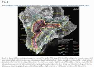
Figure in a journal article
Results for channel-fed flows superimposed on a portion of a cloud-free Landsat ETM+ image
Figure 4 in: Rowland, S. K., Garbeil, H., & Harris, A. J. (2005). Lengths and hazards from channel-fed lava flows on Mauna Loa, Hawai ‘i, determined from thermal and downslope modeling with FLOWGO. Bulletin of Volcanology, 67(7), 634-647. https://doi.org/10.1007/s00445-004-0399-x