
Advanced Search for Maps
Showing 1-8 of 8
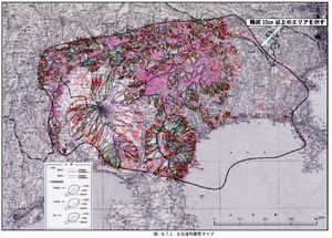
Official, Figure in hazard assessment
Debris flow possibility map
Figure 5.7.1 in: Mt. Fuji Hazard Map Review Committee. (2004). Mt. Fuji Hazard Map Review Committee Report. June 2004. https://www.bousai.go.jp/kazan/fuji_map/pdf/report_200406.pdf
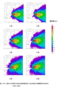
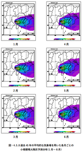
Official, Figure in hazard assessment
Monthly large-scale prediction distribution of ash fall using the average meteorological field over the past 45 years (January-June)
Figure 4.5.6 in: Mt. Fuji Hazard Map Review Committee. (2004). Mt. Fuji Hazard Map Review Committee Report. June 2004. https://www.bousai.go.jp/kazan/fuji_map/pdf/report_200406.pdf
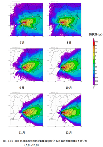
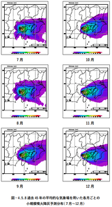
Official, Figure in hazard assessment
Monthly large-scale prediction distribution of ash fall using the average meteorological field over the past 45 years (July-December)
Figure 4.5.6 in: Mt. Fuji Hazard Map Review Committee. (2004). Mt. Fuji Hazard Map Review Committee Report. June 2004. https://www.bousai.go.jp/kazan/fuji_map/pdf/report_200406.pdf
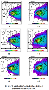
Official, Figure in hazard assessment
Monthly medium-scale eruption ash fall prediction distribution using the average meteorological field over the past 45 years (January-June)
Figure 4.5.7 in: Mt. Fuji Hazard Map Review Committee. (2004). Mt. Fuji Hazard Map Review Committee Report. June 2004. https://www.bousai.go.jp/kazan/fuji_map/pdf/report_200406.pdf
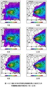
Official, Figure in hazard assessment
Monthly medium-scale eruption ash fall prediction distribution using the average meteorological field over the past 45 years (July-December)
Figure 4.5.7 in: Mt. Fuji Hazard Map Review Committee. (2004). Mt. Fuji Hazard Map Review Committee Report. June 2004. https://www.bousai.go.jp/kazan/fuji_map/pdf/report_200406.pdf
Official, Figure in hazard assessment
Monthly small-scale eruption ash fall prediction distribution using the average meteorological field over the past 45 years (January-June)
Figure 4.5.8 in: Mt. Fuji Hazard Map Review Committee. (2004). Mt. Fuji Hazard Map Review Committee Report. June 2004. https://www.bousai.go.jp/kazan/fuji_map/pdf/report_200406.pdf
Official, Figure in hazard assessment
Monthly small-scale eruption ash fall prediction distribution using the average meteorological field over the past 45 years (July-December)
Figure 4.5.8 in: Mt. Fuji Hazard Map Review Committee. (2004). Mt. Fuji Hazard Map Review Committee Report. June 2004. https://www.bousai.go.jp/kazan/fuji_map/pdf/report_200406.pdf
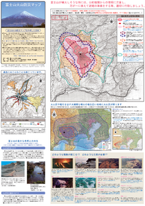
Official, Map sheet or poster
Volcanic Disaster Prevention Map of Mt.Fuji
Figure 6.3.9 in: Mt. Fuji Hazard Map Review Committee. (2004). Mt. Fuji Hazard Map Review Committee Report. June 2004. https://www.bousai.go.jp/kazan/fuji_map/pdf/report_200406.pdf