
Advanced Search for Maps
Showing 11-19 of 19
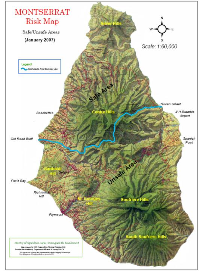
Official, Figure on website
Montserrat Risk Map Safe/Unsafe Areas (January 2007)
Montserrat Volcano Observatory (MVO). (2007). Montserrat Risk Map Safe/Unsafe Areas (January 2007). Montserrat Volcano Observatory. Risk Map - Janary 2007. https://web.archive.org/web/20070219015306fw_/http://www.mvo.ms/0701%20Risk%20Map.htm

Official, Figure on website
Montserrat Volcano Risk Map
Montserrat Volcano Observatory (MVO). (1997). Montserrat Volcano Risk Map. Montserrat Volcano Observatory. Definition Of Boundary Limits and Volcanic Risk Map for Soufriere Hills Volcano. http://www.geo.mtu.edu/volcanoes/west.indies/soufriere/govt/miscdocs/rskzone.html
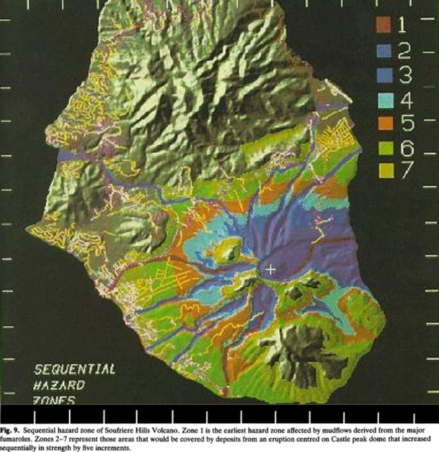
Figure in a journal article
Sequential hazard zoneof Soufriere Hills Volcano
Figure 9 in: Wadge, G. & Isaacs, M. C. (1988). Mapping the volcanic hazards from Soufriere Hills Volcano, Montserrat, West Indies using an image processor. Journal of the Geological Society, 145 (4) 541-551. https://doi.org/10.1144/gsjgs.145.4.0541
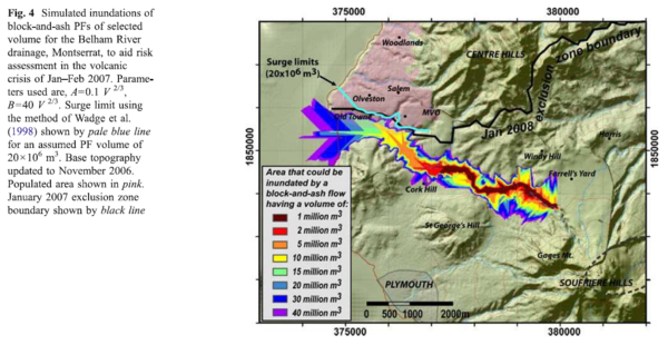
Figure in a journal article
Simulated inundations of block-and-ash PFs of selected volume for the Belham River drainage, Montserrat, to aid risk assessment in the volcanic crisis of Jan-Feb 2007.
Figure 4 in: Widiwijayanti, C., Voight, B., Hidayat, D., & Schilling, S. P. (2009). Objective rapid delineation of areas at risk from block-and-ash pyroclastic flows and surges. Bulletin of Volcanology, 71(6), p. 687-703. https://doi.org/10.1007/s00445-008-0254-6
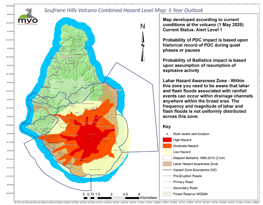
Official, Figure on website
Soufriere Hills Volcano Combined Hazard Level Map: 5 Year Outlook
Miller, V. et al. (2020) reproduced in: Montserrat Volcano Observatory. (2026). Volcanic Hazard-Previous Volcanic Hazard Maps. https://www.mvo.ms/hazards/volcanic-hazard/. Accessed 02-24-2016.
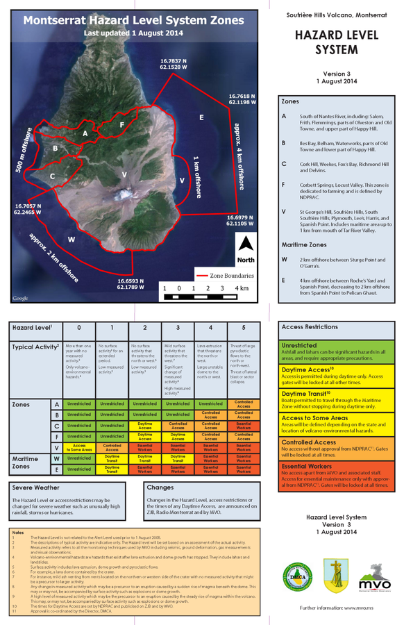
Official, Figure on website
Soufriere Hills Volcano, Monsterrat. Hazards Level System. Version 3, 1 August 2014
Montserrat Volcano Observatory (MVO). (2014). Soufrière Hills Volcano, Monsterrat. Hazard Level System. Version 3, 1 August 2014. http://www.mvo.ms/pub/Hazard_Level_System/HLS-20140801.pdf
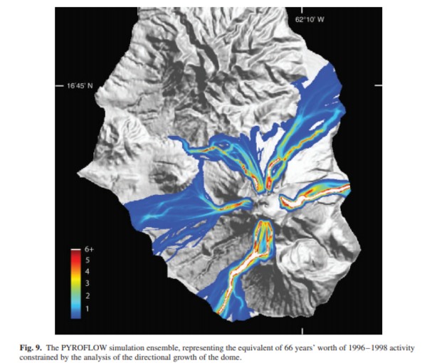
Figure in a journal article
The PYROFLOW simulation ensemble, representing the equivalent of 66 years' worth of 1996-1998 activity constrained by the analysis of the directional growth of the dome.
Figure 9 in: Wadge, G. (2009). Assessing the pyroclastic flow hazards from dome collapse at Soufriere Hills Volcano, Montserrat. In: Thordarson, S., Self, S., Larsen, G., Rowland, S.K., & Hoskuldsson, A. (Eds.) Studies in Volcanology: The Legacy of George Walker. IAVCEI, Special Publications, 2, p. 211-224. https://doi.org/10.1144/IAVCEl002.11

Official, Figure in hazard assessment
Volcanic deposits/hazard map for the Soufrière Hills Volcano
Page 163 in: Hincks, T., Sparks, S., Dunkley, P., & Cole, P. (2005). Montserrat. In: Lindsay, J.M., Shepherd, J.B., Robertson, R.E.A., & Ali, S. (Eds) Volcanic hazard atlas of the Lesser Antilles. Seismic Research Unit, The University of the West Indies, Trinidad and Tobago, W.I., p. 148-168.
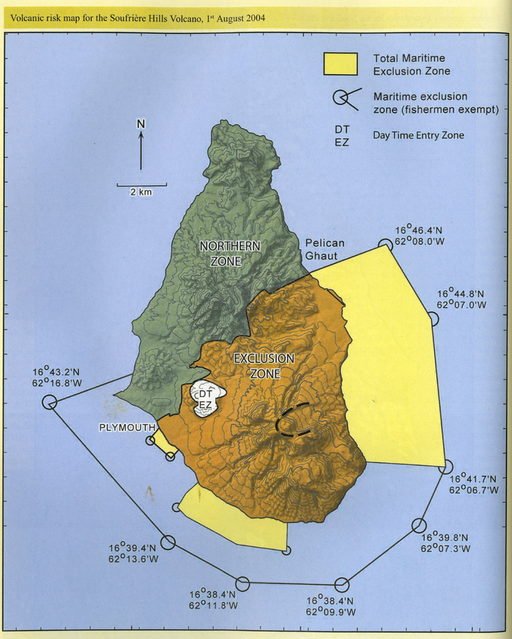
Official, Figure in hazard assessment
Volcanic risk map for the Soufrière Hills Volcano, 1st August 2004
Page 164 in: Hincks, T., Sparks, S., Dunkley, P., & Cole, P. (2005). Montserrat. In: Lindsay, J.M., Shepherd, J.B., Robertson, R.E.A., & Ali, S. (Eds) Volcanic hazard atlas of the Lesser Antilles. Seismic Research Unit, The University of the West Indies, Trinidad and Tobago, W.I., p. 148-168.
Page: 1 2