
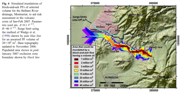
Simulated inundations of block-and-ash PFs of selected volume for the Belham River drainage, Montserrat, to aid risk assessment in the volcanic crisis of Jan-Feb 2007.
Soufrière Hills, Montserrat [United Kingdom], 2008
Figure 4 in: Widiwijayanti, C., Voight, B., Hidayat, D., & Schilling, S. P. (2009). Objective rapid delineation of areas at risk from block-and-ash pyroclastic flows and surges. Bulletin of Volcanology, 71(6), p. 687-703. https://doi.org/10.1007/s00445-008-0254-6
This hazard map is the result of scientific research and was published in academic literature.
It is presented here to serve as an example of the map type or the map-making methodology. It is NOT the official, operational map. For the current operational hazard map, please consult the proper institutional authorities.
Click on thumbnail for full-size map. We do not have copyright permission to display the full-size image. If you are the copyright holder and wish to provide copyright, please contact us at admin@volcanichazardmaps.org. If link seems broken, try the archived version.
Widiwijayanti, C., Voight, B., Hidayat, D., & Schilling, S. P. (2009). Objective rapid delineation of areas at risk from block-and-ash pyroclastic flows and surges. Bulletin of Volcanology, 71(6), p. 687-703. https://doi.org/10.1007/s00445-008-0254-6Map Set
https://doi.org/10.1007/s00445-008-0254-6
Other Maps In Set: