Advanced Search for Maps
Showing 11-20 of 20
Soufrière Guadeloupe, Guadeloupe [France]
Figure in a journal article
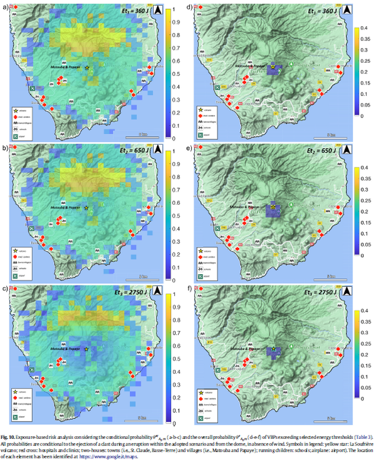
Exposure-based risk analysis considering the conditional probability and the overall probability of VBPs exceeding selected energy thresholds
Figure 10 in: Massaro, S., Rossi, E., Sandri, L., Bonadonna, C., Selva, J., Moretti, R., & Komorowski, J. C. (2022). Assessing hazard and potential impact associated with volcanic ballistic projectiles: The example of La Soufrière de Guadeloupe volcano (Lesser Antilles). Journal of volcanology and geothermal research, 423, 107453. https://doi.org/10.1016/j.jvolgeores.2021.107453
Soufrière Guadeloupe, Guadeloupe [France]
Official, Insert/poster-size map with accompanying report
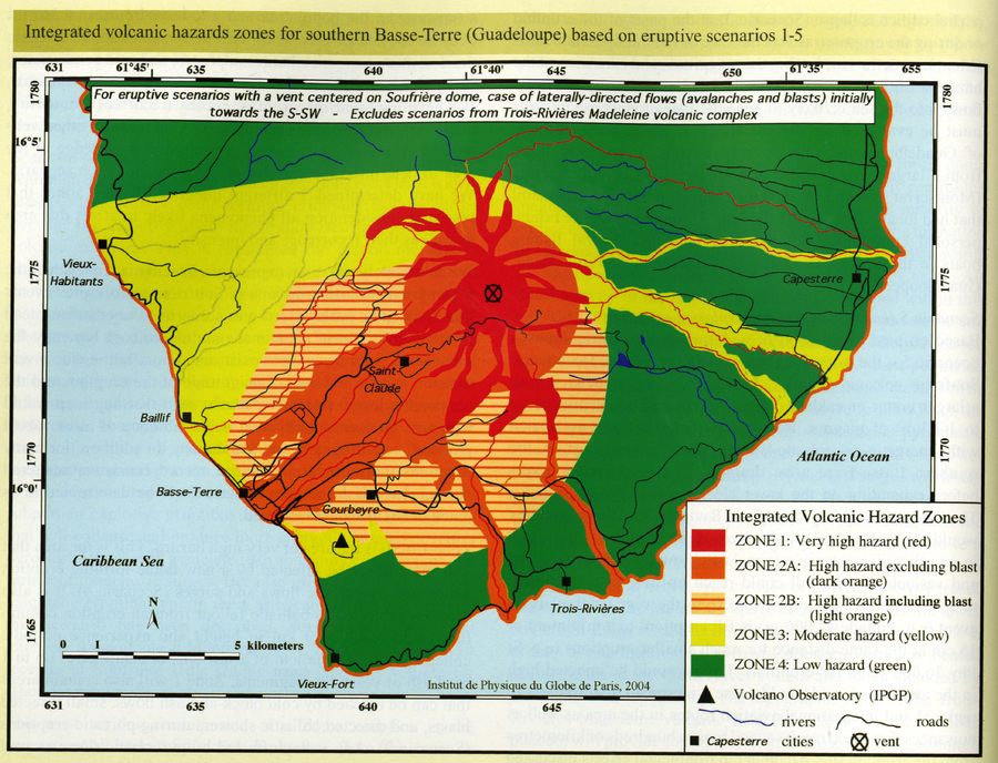
Guadeloupe - Integrated Volcanic Hazard Zones for the areas most likely to be affected in the five eruptive scenarios defined for an eruption from a vent on or within 1 km the Soufrière dome and within the S-SW oriented most-recent edifice collapse depression and with the assumption of the presence of easterly trade winds between 0 and 5-8 km altitude
Pocket insert in: Komorowski, J.-C., Boudon, G., Michel-Semet, Beauducel, F., Anténor-Habazac, C., Bazin, S., & Hammouya, G. (2005). Guadeloupe. In: Lindsay, J.M., Shepherd, J.B., Robertson, R.E.A., & Ali, S. (Eds) Volcanic hazard atlas of the Lesser Antilles. Seismic Research Unit, The University of the West Indies, Trinidad and Tobago, W.I., p. 68-106.
Soufrière Guadeloupe, Guadeloupe [France]
Official, Figure in hazard assessment
Integrated volcanic hazards zones for southern Basse-Terre (Guadeloupe) based on eruptive scenarios 1-5
Page 98 in: Komorowski, J.-C., Boudon, G., Michel-Semet, Beauducel, F., Anténor-Habazac, C., Bazin, S., & Hammouya, G. (2005). Guadeloupe. In: Lindsay, J.M., Shepherd, J.B., Robertson, R.E.A., & Ali, S. (Eds) Volcanic hazard atlas of the Lesser Antilles. Seismic Research Unit, The University of the West Indies, Trinidad and Tobago, W.I., p. 68-106.
Soufrière Guadeloupe, Guadeloupe [France]
Official, Figure in hazard assessment
Localisation des Secteurs Susceptibles de Glisser sous L'action des Explosions Phréatiques ou des Secousses Sismiques Superficielles
(Location of Sectors Likely to Slip Under the Action of Ground Explosions or Superficial Earthquakes)
Figure 13 in: Westercamp, D. (1977) Levés géologiques, évaluation et zonation des risques volcaniques à la Soufrière de Guadeloupe F. W. I. (Rapport de mission) Mai-Juin 1977. Délégation Générale a la Recherche Scientifique et Technique. 77 Ant 29
Soufrière Guadeloupe, Guadeloupe [France]
Figure in a journal article
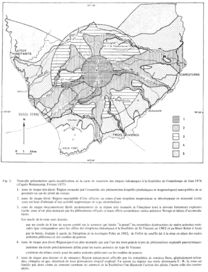
Nouvelle présentation après modification de la carte de zonation des risques volcaniques à la Soufrière de Guadeloupe de Juin 1976 (d'après Westercamp, Février 1977)
(New presentation after modification of the zonation map of volcanic risks at Soufrière in Guadeloupe from June 1976 (from Westercamp, February 1977))
Figure 3 in: Westercamp, D. (1981). Cartographie du risque volcanique a la soufriere de guadeloupe: Retrospective et tendance actuelle. Bulletin of the International Association of Engineering Geology-Bulletin de l'Association Internationale de Géologie de l'Ingénieur, 23(1), p. 25-32. https://doi.org/10.1007/BF02594723
Soufrière Guadeloupe, Guadeloupe [France]
Figure in a journal article
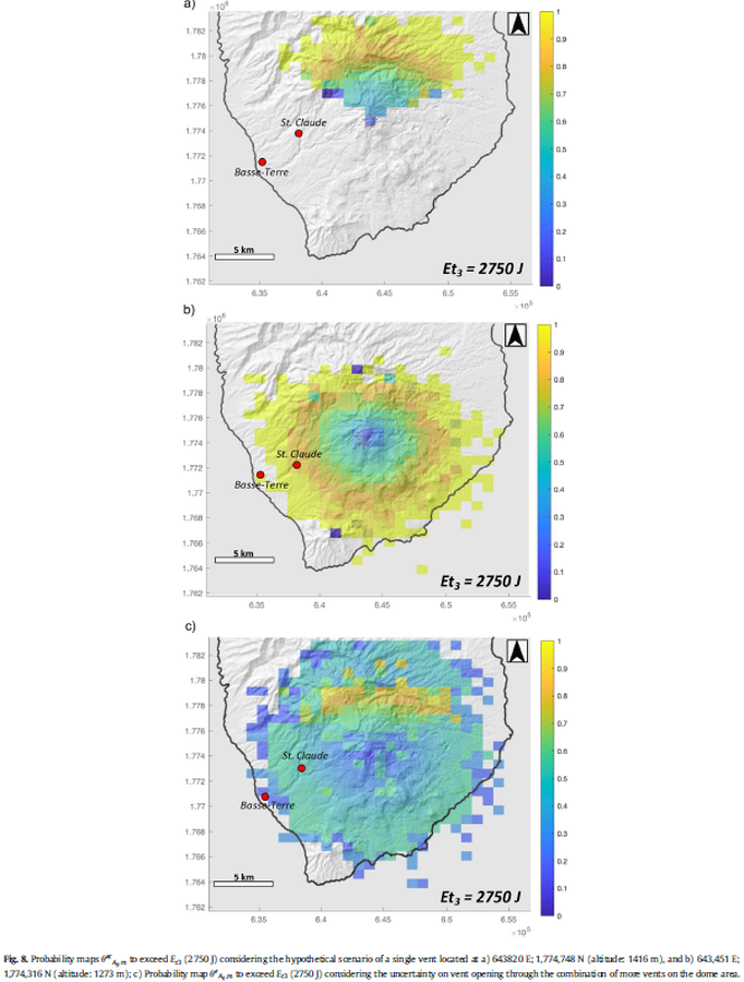
Probability maps to exceed Et3 (2750 J) considering the hypothetical scenario of a single vent
Figure 8 in: Massaro, S., Rossi, E., Sandri, L., Bonadonna, C., Selva, J., Moretti, R., & Komorowski, J. C. (2022). Assessing hazard and potential impact associated with volcanic ballistic projectiles: The example of La Soufrière de Guadeloupe volcano (Lesser Antilles). Journal of volcanology and geothermal research, 423, 107453. https://doi.org/10.1016/j.jvolgeores.2021.107453
Soufrière Guadeloupe, Guadeloupe [France]
Official, Figure in hazard assessment
Types de Repartition des Cendres Soumises a l'Action d'un Vent Dominant
(Types of Distribution of Ashes Subjected to the Action of a Dominant Wind)
Figure 4 in: Westercamp, D. (1976). Dynamismes Éruptifs et Zonation des Risques Volcaniques a la Sourfrière de Guadeloupe. Bureau de Recherches Géologiques, Service Geologique des Antilles.
Soufrière Guadeloupe, Guadeloupe [France]
Official, Figure in hazard assessment
Zonation des Depôts et des Regions Soumises à l'Effet du Souffle des Nuées Ardentes du Type St Vincent 1902 à la Soufrière de Guadeloupe
(Zoning of the Depots and Regions Subject to the Effect of the Breath of the Burning Clouds of the St Vincent Type 1902 at La Soufrière in Guadeloupe)
Figure 18 in: Westercamp, D. (1977) Levés géologiques, évaluation et zonation des risques volcaniques à la Soufrière de Guadeloupe F. W. I. (Rapport de mission) Mai-Juin 1977. Délégation Générale a la Recherche Scientifique et Technique. 77 Ant 29
Soufrière Guadeloupe, Guadeloupe [France]
Official, Figure in hazard assessment
Zonation des Risques Potentiels de Coulées de Lave a la Soufriére de Guadeloupe
(Zoning of Potential Risks of Lava Flows in the Soufriere of Guadeloupe)
Figure 19 in: Westercamp, D. (1977) Levés géologiques, évaluation et zonation des risques volcaniques à la Soufrière de Guadeloupe F. W. I. (Rapport de mission) Mai-Juin 1977. Délégation Générale a la Recherche Scientifique et Technique. 77 Ant 29
Soufrière Guadeloupe, Guadeloupe [France]
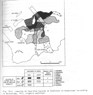
Figure in a journal article
Zonation of lava-flow hazards at Soufrière in Guadeloupe (according to Westercamp, 1977, slightly modified)
Figure 10.4 in: Westercamp, D. (1983). Appraisal and zonation of volcanic hazards in the French Lesser Antilles: preliminary results. In: Tazieff, H. & Sabroux, J.-C. (Eds.) Forecasting Volcanic Events, Elsevier, Amsterdam, p. 111-130.
Page: 1 2