
Advanced Search for Maps
Showing 11-20 of 118
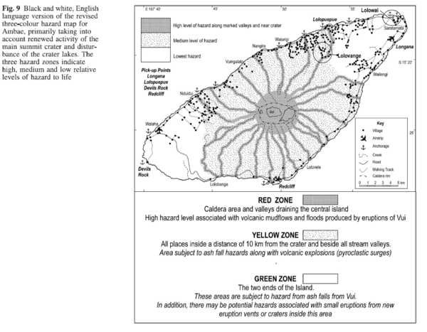
Figure in a journal article
Black and white, English language version of the revised three-colour hazard map for Ambae, primarily taking into account renewed activity of the main summit crater and disturbance of the crater lakes
Figure 9 in: Cronin, S.J., Gaylord, D.R., Charley, D., Alloway, B.V., Wallez, S., & Esau, J.W. (2004). Participatory methods of incorporating scientific with traditional knowledge for volcanic hazard management on Ambae Island, Vanuatu. Bulletin of volcanology, 66(7), p. 652-668. https://doi.org/10.1007/s00445-004-0347-9
Official, Map sheet or poster
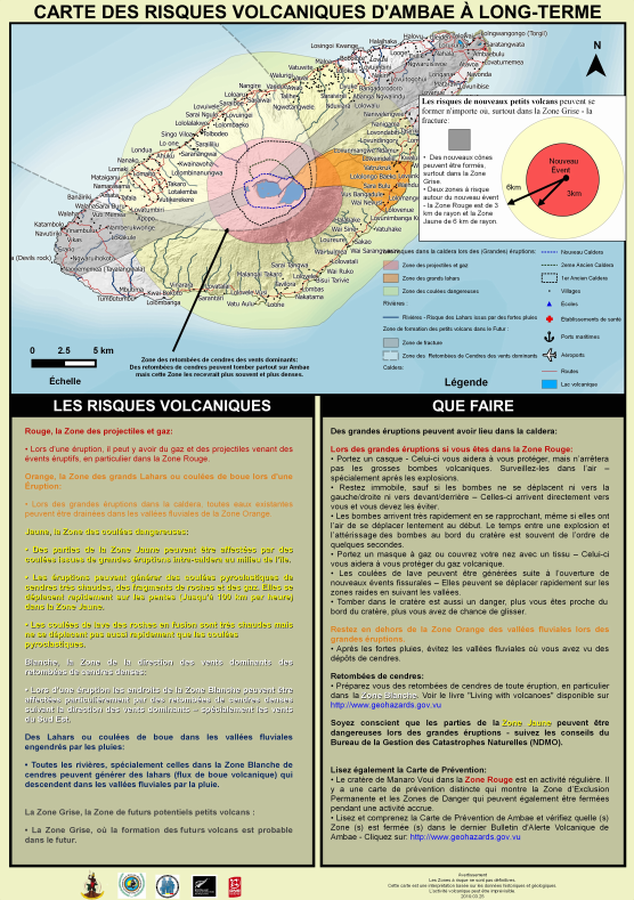
Carte des Risques Volcaniques d'Ambae à Long-terme
(Ambae Long-Term Background Volcanic Hazards Map)
Vanuatu Meteorology & Geo-Hazards Department. (2019). Carte des Risques Volcaniques d'Ambae à Long-terme. Government of Vanuatu, Vanuatu Meteorology & Geo-Hazards Department, Vanuatu National Disaster Risk Management Office, New Zealand Foreign Affairs & Trade Aid Programme, GNS Science.
Official, Map sheet or poster
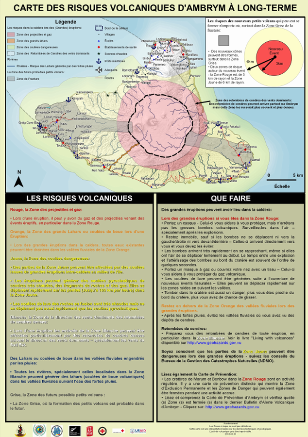
Carte des Risques Volcaniques d'Ambrym à Long-terme
(Ambrym Long-Term Background Volcanic Hazards Map)
Vanuatu Meteorology & Geo-Hazards Department. (2016). Carte des Risques Volcaniques d'Ambrym à Long-terme. Government of Vanuatu, Vanuatu Meteorology & Geo-Hazards Department, Vanuatu National Disaster Risk Management Office, New Zealand Foreign Affairs & Trade Aid Programme, GNS Science, The Vanuatu Red Cross Society, Croix Rouge Francaise, USAID.
Official, Map sheet or poster
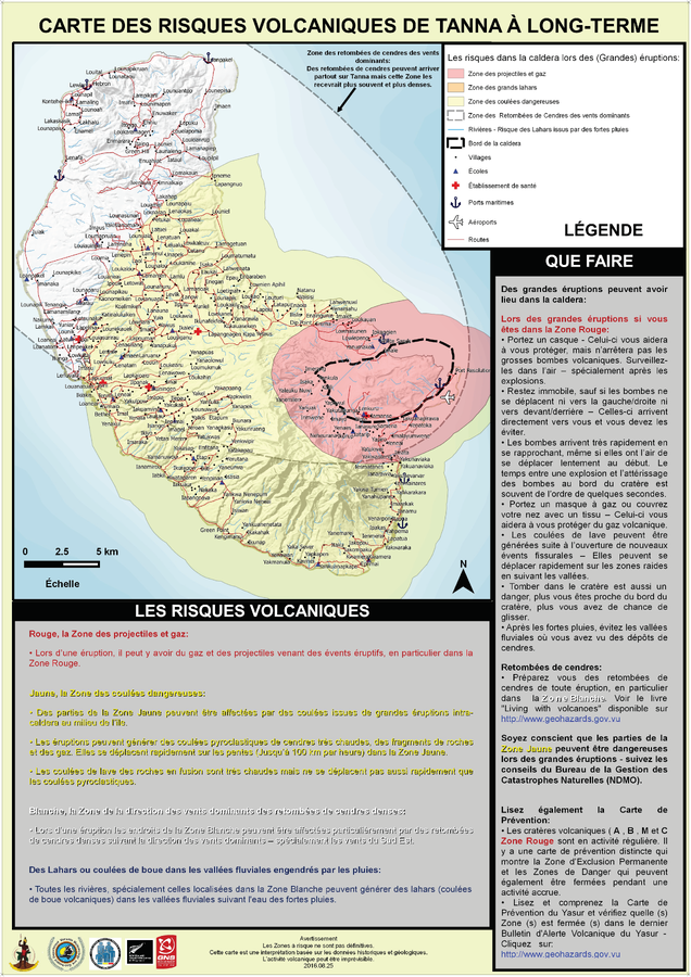
Carte des Risques Volcaniques de Tanna à Long-Terme
(Tanna Long-Term Background Volcanic Hazards Map)
Vanuatu Meteorology & Geo-Hazards Department. (2016). Carte des Risques Volcaniques de Tanna à Long-Terme. Government of Vanuatu, Vanuatu Meteorology & Geo-Hazards Department, Vanuatu National Disaster Risk Management Office, New Zealand Foreign Affairs & Trade Aid Programme, GNS Science.
Official, Map in an information statement
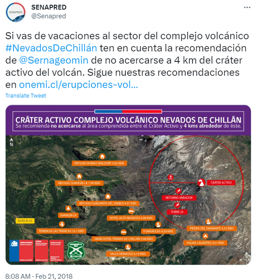
Cráter Activo Complejo Volcánico Nevados de Chillán
(Nevados de Chillán Active Crater Complex )
Servicio Nacional de Geología y Minería (SERNAGEOMIN) & Oficina Nacional de Emergencia del Ministerio del Interior y Seguridad Pública (ONEMI). (2018). Cráter Activo Complejo Volcánico Nevados de Chillán. Twitter. https://twitter.com/Senapred/status/966343871520215040
Official, Map in an information statement
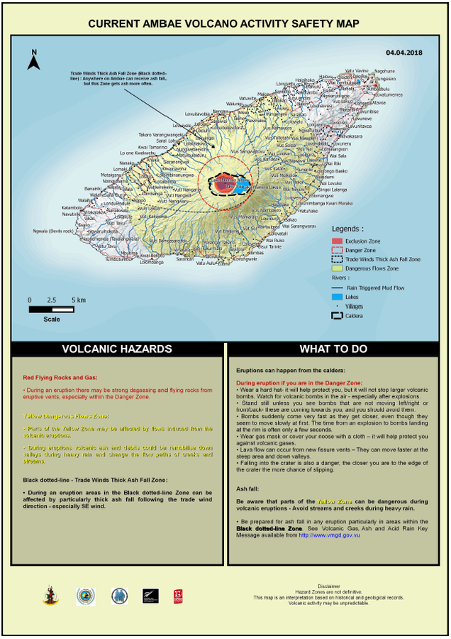
Current Ambae Volcano Activity Safety Map
Vanuatu Meteorology & Geo-Hazards Department. (2018). Current Ambae Volcano Activity Safety Map 04.04.2018. Government of Vanuatu, Vanuatu Meteorology & Geo-Hazards Department, Vanuatu National Disaster Risk Management Office, New Zealand Foreign Affairs & Trade Aid Programme, GNS Science.
Official, Map in an information statement
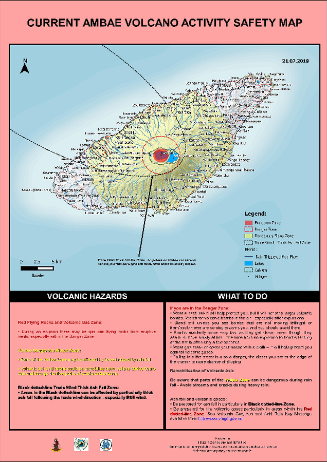
Current Ambae Volcano Activity Safety Map
Vanuatu Meteorology & Geo-Hazards Department. (2018). Current Ambae Volcano Activity Safety Map 21.07.2018. Government of Vanuatu, Vanuatu Meteorology & Geo-Hazards Department, Vanuatu National Disaster Risk Management Office, New Zealand Foreign Affairs & Trade Aid Programme, GNS Science.
Official, Figure in hazard assessment
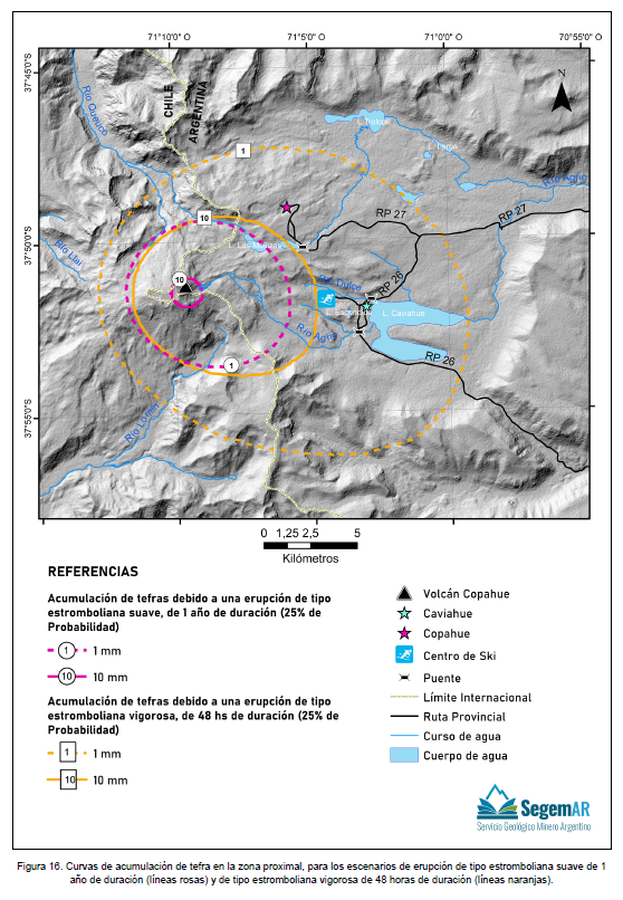
Curvas de acumulación de tefra en la zona proximal, para los escenarios de erupción de tipo estromboliana suave de 1 año de duración (líneas rosas) y de tipo estromboliana vigorosa de 48 horas de duración (líneas naranjas)
(Tephra accumulation curves in the proximal zone, for the mild Strombolian type eruption scenarios lasting 1 year (pink lines) and the vigorous Strombolian type erupting for 48 hours (orange lines))
Figure 16 in: Kaufman, J. F., Elissondo, M., Sruoga, P., Yamín, M. G. 2023. Peligrosidad del volcán Copahue. Provincia del Neuquén, República Argentina. Serie de Contribuciones Técnicas Peligrosidad Geológica N° 24. 51 pp. Buenos Aires, Servicio Geológico Minero Argentino (SEGEMAR). Instituto de Geología y Recursos Minerales.
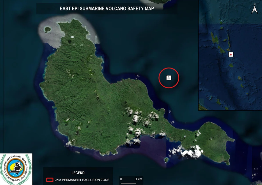
Official, Map in an information statement
East Epi Submarine Volcano Safety Map
Vanuatu Meteorology & Geo-Hazards Department. (2025). Vanuatu Volcano Alert Bulletin n°01 - East Epi Activity (Thursday March 27th 2025). Government of Vanuatu, Vanuatu Meteorology & Geo-Hazards Department.
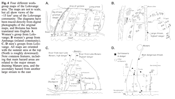
Figure in a journal article
Four different workgroup maps of the Lolovange area
Figure 4 in: Cronin, S.J., Gaylord, D.R., Charley, D., Alloway, B.V., Wallez, S., & Esau, J.W. (2004). Participatory methods of incorporating scientific with traditional knowledge for volcanic hazard management on Ambae Island, Vanuatu. Bulletin of volcanology, 66(7), p. 652-668. https://doi.org/10.1007/s00445-004-0347-9