
Advanced Search for Maps
Showing 21-25 of 25
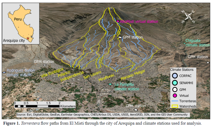
Figure in a journal article
Torrentera flow paths from El Misti through the city of Arequipa and climate stations used for analysis
Figure 1 in: Mazer, K. E., Tomasek, A. A., Daneshvar, F., Bowling, L. C., Frankenberger, J. R., McMillan, S. K., Novoa, H.M., & Zeballos‐Velarde, C. (2021). Integrated hydrologic and hydraulic analysis of torrential flood hazard in Arequipa, Peru. Journal of Contemporary Water Research & Education, 171(1), 93-110. https://doi.org/10.1111/j.1936-704X.2020.3347.x
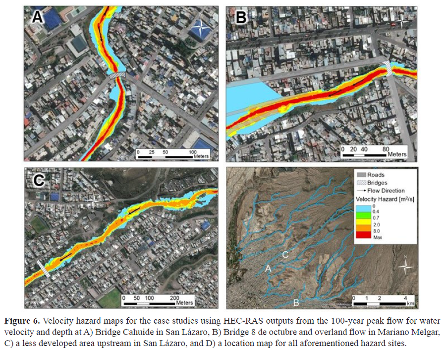
Figure in a journal article
Velocity hazard maps for the case studies using HEC-RAS outputs from the 100-year peak flow for water velocity and depth
Figure 6 in: Mazer, K. E., Tomasek, A. A., Daneshvar, F., Bowling, L. C., Frankenberger, J. R., McMillan, S. K., Novoa, H.M., & Zeballos‐Velarde, C. (2021). Integrated hydrologic and hydraulic analysis of torrential flood hazard in Arequipa, Peru. Journal of Contemporary Water Research & Education, 171(1), 93-110. https://doi.org/10.1111/j.1936-704X.2020.3347.x
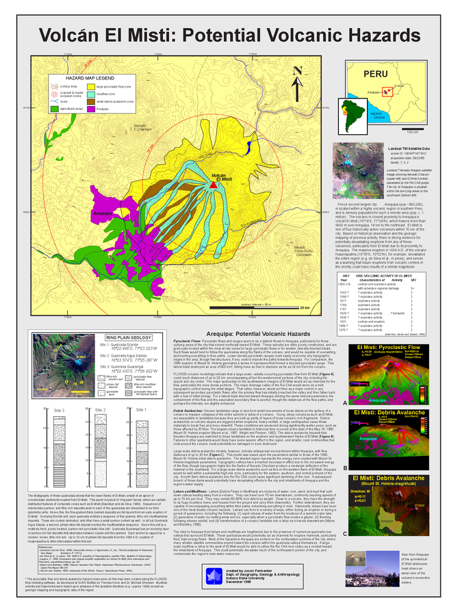
Figure in a thesis or dissertation
Volcán El Misti: Potential Volcanic Hazards
Permenter, J.L. (1999). A Preliminary Volcanic Hazard Assessment for the Arequipa Region, Southern Peru. MS Thesis. Department of Geography, Geology, and Anthropology, Indiana State University, Terre Haute, Indiana.
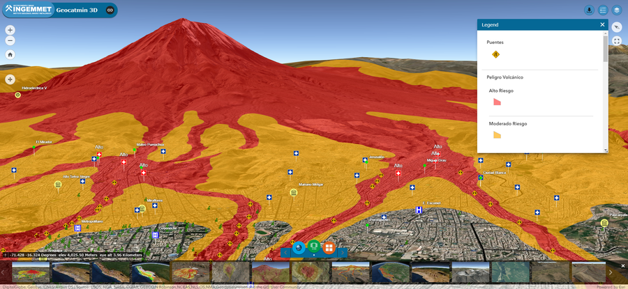
Official, Interactive web-based map
Volcan Misti 3D
(Misti Volcano 3D)
Instituto Geológico Minero y Metalúrgico (INGEMMET). (2019). Volcan Misti 3D. Mapa de Peligros Volcanico Interativo 3D.
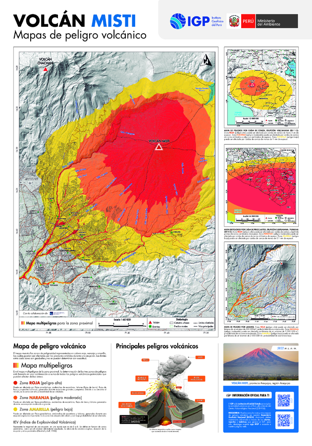
Official, Map sheet or poster
Volcán Misti: Mapas de peligro volcánico
(Misti Volcano: Volcanic Hazard Maps)
Rivera, M., Cuno, J., Valdivia, D., Lazarte, I., Del Carpio, J. (2024). Mapa de peligros del volcán Misti. Informe técnico, 2024. Instituto Geofísico del Perú. http://hdl.handle.net/20.500.12816/5633