← Back to Search Results

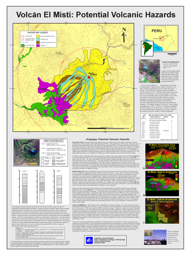
Volcán El Misti: Potential Volcanic Hazards

El Misti, Peru, 1999

Permenter, J.L. (1999). A Preliminary Volcanic Hazard Assessment for the Arequipa Region, Southern Peru. MS Thesis. Department of Geography, Geology, and Anthropology, Indiana State University, Terre Haute, Indiana.


This hazard map is the result of scientific research and was published in academic literature. It is presented here to serve as an example of the map type or the map-making methodology. It is NOT the official, operational map. For the current operational hazard map, please consult the proper institutional authorities.

Map Set

Permenter, J.L. (1999). A Preliminary Volcanic Hazard Assessment for the Arequipa Region, Southern Peru. MS Thesis. Department of Geography, Geology, and Anthropology, Indiana State University, Terre Haute, Indiana.

Map Data

Map ID3918
Hazard Process(es)Debris avalanches; Lahars; Lateral or directed blasts; PDCs; Surges
Hazard Zone PresentationHazard process-focused: Most hazard processes are separated by hazard process type on a main map and series of insets
Temporal ScaleBackground, or long-term, map
Spatial ScaleVolcano and surrounding area
Publication FormatFigure in a thesis or dissertation
Zonation Method(s)Geologic history; Scenario modeling
Zonation Model(s)FLOW2D or FLOW3D (Sheridan & Macías 1992; Kover 1995)
Scenario(s) ConsideredAnalog volcano(es); Size, VEI, or intensity; Style or type
Hazard Zone Label(s)Estimated value or Hazard Impact Metric; Hazard process name
Probability Definition(s)Scenarios imply probability
PurposeScientific interest: Intended for scientific research and general scientific interest; usually published in academic journals
AudienceScientists (usually in scientific publication)
Language(s)English
Basemap(s)Contour lines
Basemap overlay(s)
DiemsionalityPlanimetric (2D or map) view
Color SchemeCategorical/Qualitative
Go to Global Volcanism Program page for El Misti →