
Advanced Search for Maps
Showing 31-40 of 93
Official, Figure in hazard assessment
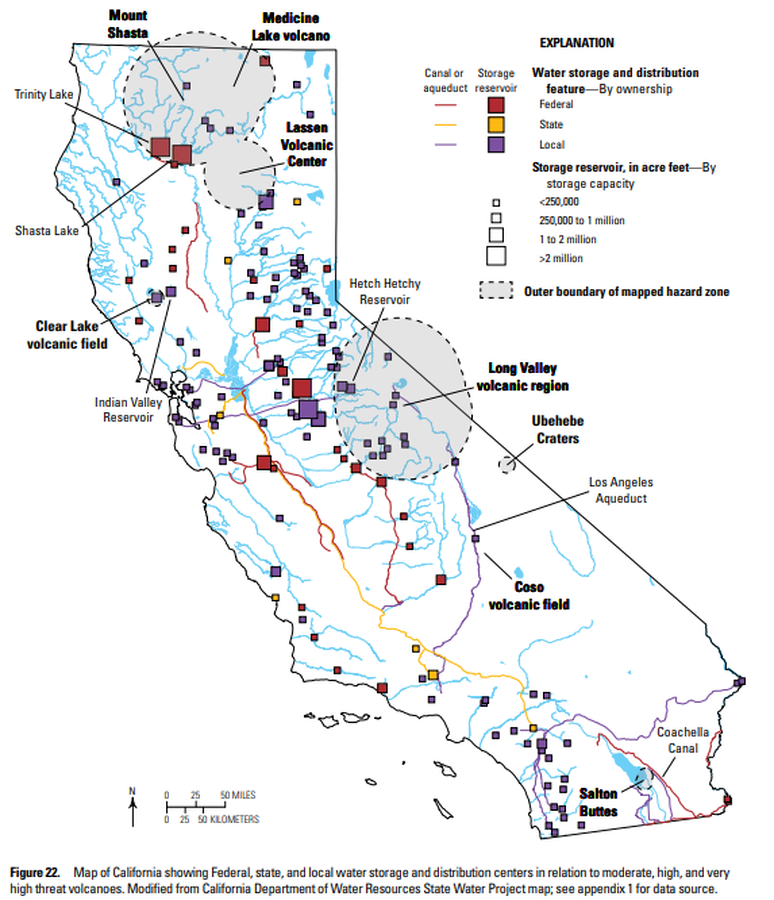
Map of California showing Federal, state, and local water storage and distribution centers in relation to moderate, high, and very high threat volcanoes
Figure 22 in: Mangan, M., Ball, J., Wood, N., Jones, J.L., Peters, J., Abdollahian, N., Dinitz, L., Blankenheim, S., Fenton, J., & Pridmore, C. (2019). California’s exposure to volcanic hazards. U.S. Geological Survey Scientific Investigations Report 2018–5159, v. 1.1, 49 p. https://doi.org/10.3133/sir20185159
Official, Figure in hazard assessment
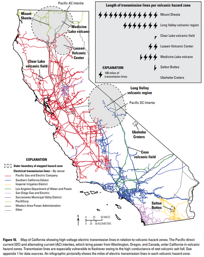
Map of California showing high-voltage electric transmission lines in relation to volcanic hazard zones
Figure 16 in: Mangan, M., Ball, J., Wood, N., Jones, J.L., Peters, J., Abdollahian, N., Dinitz, L., Blankenheim, S., Fenton, J., & Pridmore, C. (2019). California’s exposure to volcanic hazards. U.S. Geological Survey Scientific Investigations Report 2018–5159, v. 1.1, 49 p. https://doi.org/10.3133/sir20185159
Official, Figure in hazard assessment
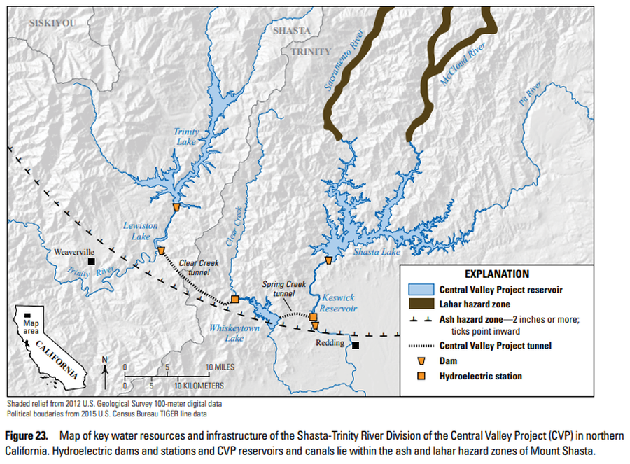
Map of key water resources and infrastructure of the Shasta-Trinity River Division of the Central Valley Project (CVP) in northern California
Figure 23 in: Mangan, M., Ball, J., Wood, N., Jones, J.L., Peters, J., Abdollahian, N., Dinitz, L., Blankenheim, S., Fenton, J., & Pridmore, C. (2019). California’s exposure to volcanic hazards. U.S. Geological Survey Scientific Investigations Report 2018–5159, v. 1.1, 49 p. https://doi.org/10.3133/sir20185159
Official, Figure in hazard assessment
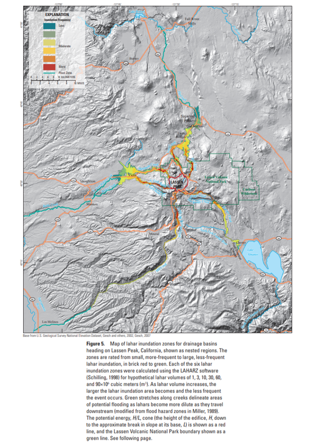
Map of lahar inundation zones for drainage basins
Figure 5 in: Robinson, J. E. & Clynne, M. A. (2012). Lahar Hazard Zones for Eruption-Generated Lahars in the Lassen Volcanic Center, California. U.S. Geological Survey Scientific Investigations Report , 2012-5176-C, 13 p. https://doi.org/10.3133/sir20125176C
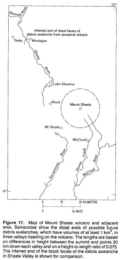
Official, Figure in hazard assessment
Map of Mount Shasta volcano and adjacent area.
Figure 17 in: Crandell, D.R. (1989). Gigantic debris avalanche of Pleistocene age from ancestral Mount Shasta Volcano, California, and debris-avalanche hazard zonation. U.S. Geological Survey, Bulletin 1861, 32 p. https://doi.org/10.3133/b1861

Official, Figure in hazard assessment
Map of natural gas pipelines and substations in northern California
Figure 20 in: Mangan, M., Ball, J., Wood, N., Jones, J.L., Peters, J., Abdollahian, N., Dinitz, L., Blankenheim, S., Fenton, J., & Pridmore, C. (2019). California’s exposure to volcanic hazards. U.S. Geological Survey Scientific Investigations Report 2018–5159, v. 1.1, 49 p. https://doi.org/10.3133/sir20185159
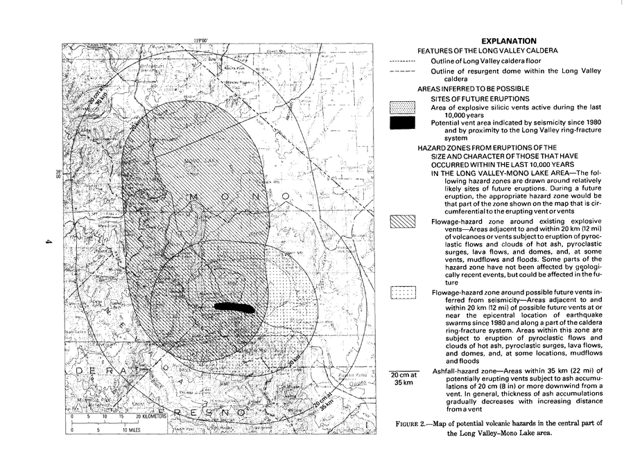
Official, Figure in hazard assessment
Map of potential volcanic hazards in the central part of the Long Valley-Mono Lake area
Figure 2 in: Miller, C.D., Mullineaux, D.R., Crandell, D.R. & Bailey, R.A. (1982). Potential hazards from future volcanic eruptions in the Long Valley-Mono Lake area, east-central California and southwest Nevada; a preliminary assessment. U.S. Geological Survey, Circular 877, 10 p. https://doi.org/10.3133/cir877
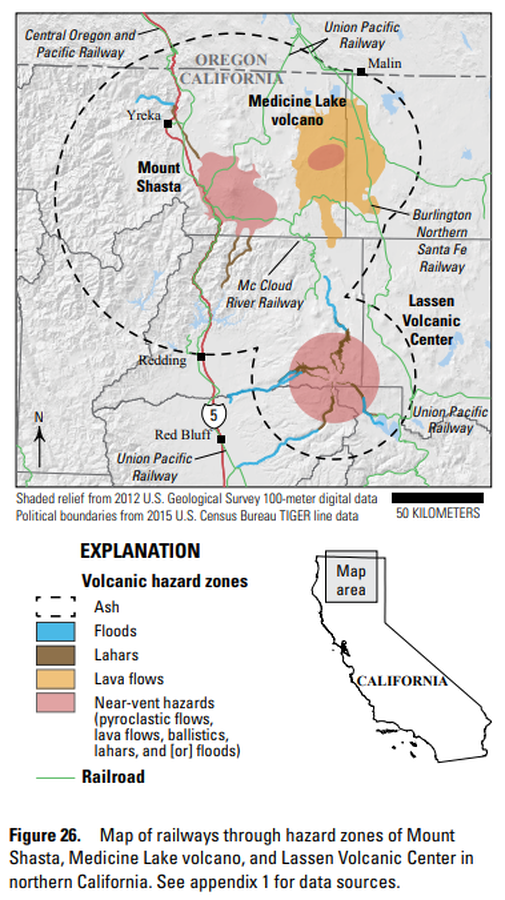
Official, Figure in hazard assessment
Map of railways through hazard zones of Mount Shasta, Medicine Lake volcano, and Lassen Volcanic Center in northern California
Figure 26 in: Mangan, M., Ball, J., Wood, N., Jones, J.L., Peters, J., Abdollahian, N., Dinitz, L., Blankenheim, S., Fenton, J., & Pridmore, C. (2019). California’s exposure to volcanic hazards. U.S. Geological Survey Scientific Investigations Report 2018–5159, v. 1.1, 49 p. https://doi.org/10.3133/sir20185159
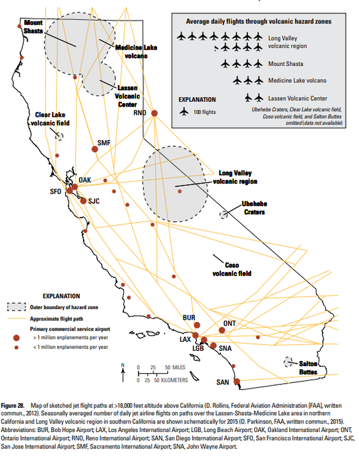
Official, Figure in hazard assessment
Map of sketched jet flight paths at >18,000 feet altitude above California
Figure 28 in: Mangan, M., Ball, J., Wood, N., Jones, J.L., Peters, J., Abdollahian, N., Dinitz, L., Blankenheim, S., Fenton, J., & Pridmore, C. (2019). California’s exposure to volcanic hazards. U.S. Geological Survey Scientific Investigations Report 2018–5159, v. 1.1, 49 p. https://doi.org/10.3133/sir20185159
Official, Figure in hazard assessment
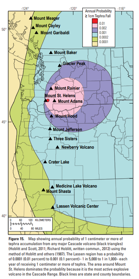
Map showing annual probability of 1 centimeter or more of tephra accumulation from any major Cascade volcano
Figure 15 in: Clynne, M. A., Robinson, J. E., Nathenson, M. & Muffler, L. P. (2012). Volcano hazards assessment for the Lassen region, northern California. U.S. Geological Survey, Scientific Investigations Report 2012-5176-A, 47 p., 1 plate. https://doi.org/10.3133/sir20125176A