← Back to Search Results

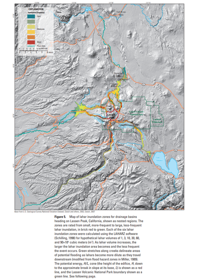
Map of lahar inundation zones for drainage basins

Lassen Volcanic Center, United States, 2012

Figure 5 in: Robinson, J. E. & Clynne, M. A. (2012). Lahar Hazard Zones for Eruption-Generated Lahars in the Lassen Volcanic Center, California. U.S. Geological Survey Scientific Investigations Report , 2012-5176-C, 13 p. https://doi.org/10.3133/sir20125176C


This map was produced by an official agency, but is NOT the most recent, most complete, or main operational map. For the current operational hazard map, please consult the proper institutional authorities.


Click on image for full-size map. If link seems broken, try the archived version.

Map Data

Map ID588
Hazard Process(es)Floods or jokulhaups; Lahars
Hazard Zone PresentationSingle hazard: A single hazard process is represented on a main map panel
Temporal ScaleBackground, or long-term, map
Spatial ScaleVolcano and surrounding area
Publication FormatFigure in a hazard assessment or mitigation plan
Zonation Method(s)Geologic history; Scenario modeling
Zonation Model(s)LAHARZ or modified version (such as PFZ) (Iverson et al. 1998; Schilling 1998; Schilling 2014)
Scenario(s) ConsideredSize, VEI, or intensity
Hazard Zone Label(s)Hazard process name; Qualitative relative probability (e.g. high-medium-low)
Probability Definition(s)Qualitative relative probability (e.g. high-medium-low)
PurposeMultiple: intended for multiple purposes including general hazard awareness, planning, and crisis management
AudienceMultiple audiences (usually the public, civil authorities, and land-use planners)
Language(s)English
Basemap(s)Hillshade
Basemap overlay(s)Street map
DiemsionalityPlanimetric (2D or map) view
Color SchemeRainbow
Go to Global Volcanism Program page for Lassen Volcanic Center →