
Advanced Search for Maps
Showing 1-10 of 12
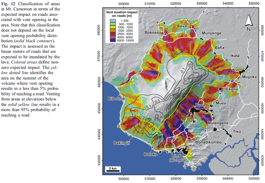
Figure in a journal article
Classification of areas at Mt. Cameroon in terms of the expected impact on roads associated with vent opening in the area
Figure 12 in: Favalli, M., Tarquini, S., Papale, P., Fornaciai, A., & Boschi, E. (2012). Lava flow hazard and risk at Mt. Cameroon volcano. Bulletin of Volcanology, 74(2), 423-439. https://doi.org/10.1007/s00445-011-0540-6
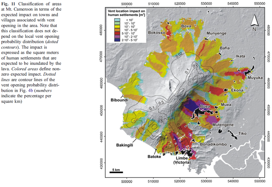
Figure in a journal article
Classification of areas at Mt. Cameroon in terms of the expected impact on towns and villages associated with vent opening in the area
Figure 11 in: Favalli, M., Tarquini, S., Papale, P., Fornaciai, A., & Boschi, E. (2012). Lava flow hazard and risk at Mt. Cameroon volcano. Bulletin of Volcanology, 74(2), 423-439. https://doi.org/10.1007/s00445-011-0540-6
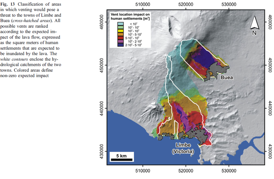
Figure in a journal article
Classification of areas in which venting would pose a threat to the towns of Limbe and Buea
Figure 13 in: Favalli, M., Tarquini, S., Papale, P., Fornaciai, A., & Boschi, E. (2012). Lava flow hazard and risk at Mt. Cameroon volcano. Bulletin of Volcanology, 74(2), 423-439. https://doi.org/10.1007/s00445-011-0540-6
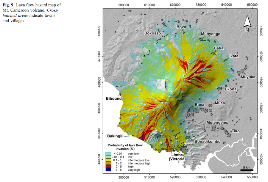
Figure in a journal article
Lava flow hazard map of Mt. Cameroon volcano
Figure 9 in: Favalli, M., Tarquini, S., Papale, P., Fornaciai, A., & Boschi, E. (2012). Lava flow hazard and risk at Mt. Cameroon volcano. Bulletin of Volcanology, 74(2), 423-439. https://doi.org/10.1007/s00445-011-0540-6
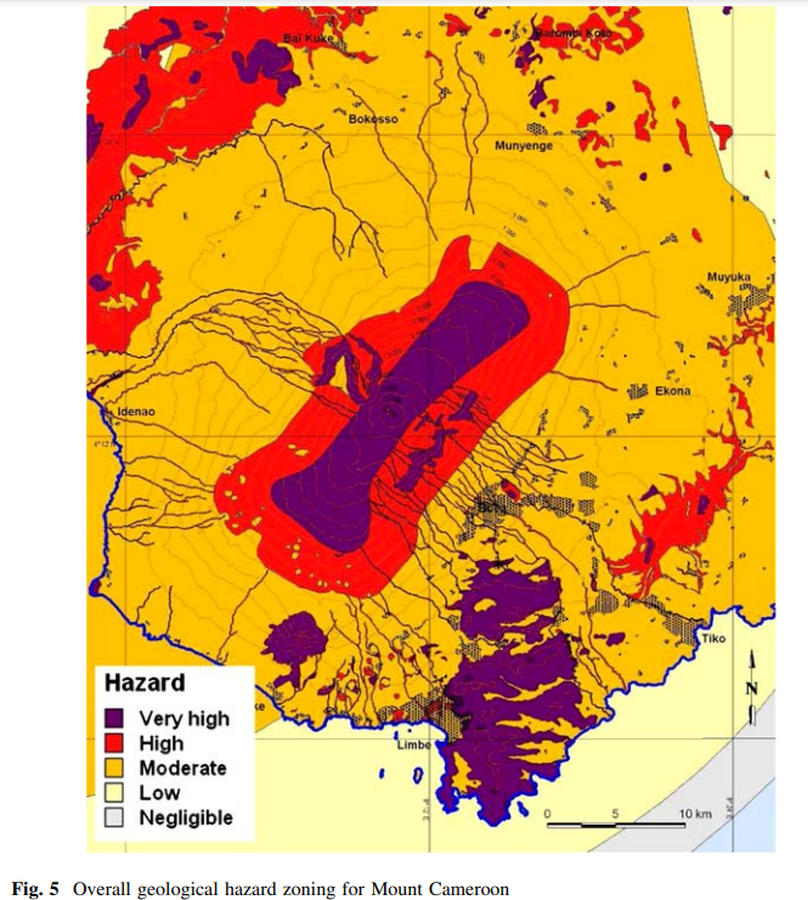
Figure in a journal article
Overall geological hazard zoning for Mount Cameroon
Figure 5 in: Thierry, P., Stieltjes, L., Kouokam, E., Nguéya, P., & Salley, P. M. (2008). Multi-hazard risk mapping and assessment on an active volcano: the GRINP project at Mount Cameroon. Natural Hazards, 45(3), 429-456. https://doi.org/10.1007/s11069-007-9177-3
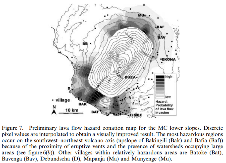
Figure in a journal article
Preliminary lava flow hazard zonation map for the MC lower slopes
Figure 7 in: Bonne, K., Kervyn, M., Cascone, L., Njome, S., Van Ranst, E., Suh, E., Ayonghe, S., & Ernst, G. (2008). A new approach to assess long‐term lava flow hazard and risk using GIS and low‐cost remote sensing: the case of Mount Cameroon, West Africa. International Journal of Remote Sensing, 29(22), 6539-6564. https://doi.org/10.1080/01431160802167873
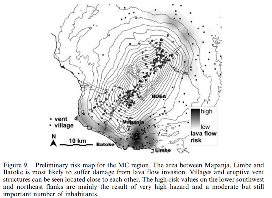
Figure in a journal article
Preliminary risk map for the MC region
Figure 9 in: Bonne, K., Kervyn, M., Cascone, L., Njome, S., Van Ranst, E., Suh, E., Ayonghe, S., & Ernst, G. (2008). A new approach to assess long‐term lava flow hazard and risk using GIS and low‐cost remote sensing: the case of Mount Cameroon, West Africa. International Journal of Remote Sensing, 29(22), 6539-6564. https://doi.org/10.1080/01431160802167873
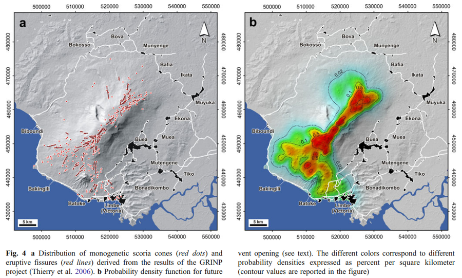
Figure in a journal article
Probability density function for future vent opening.
Figure 4 in: Favalli, M., Tarquini, S., Papale, P., Fornaciai, A., & Boschi, E. (2012). Lava flow hazard and risk at Mt. Cameroon volcano. Bulletin of Volcanology, 74(2), 423-439. https://doi.org/10.1007/s00445-011-0540-6
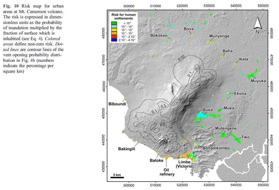
Figure in a journal article
Risk map for urban areas at Mt. Cameroon volcano
Figure 10 in: Favalli, M., Tarquini, S., Papale, P., Fornaciai, A., & Boschi, E. (2012). Lava flow hazard and risk at Mt. Cameroon volcano. Bulletin of Volcanology, 74(2), 423-439. https://doi.org/10.1007/s00445-011-0540-6
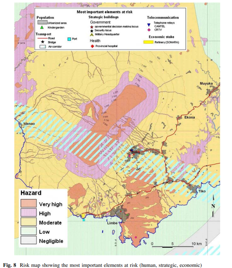
Figure in a journal article
Risk map showing the most important elements at risk (human, strategic, economic)
Figure 8 in: Thierry, P., Stieltjes, L., Kouokam, E., Nguéya, P., & Salley, P. M. (2008). Multi-hazard risk mapping and assessment on an active volcano: the GRINP project at Mount Cameroon. Natural Hazards, 45(3), 429-456. https://doi.org/10.1007/s11069-007-9177-3
Page: 1 2