
Advanced Search for Maps
Showing 1-10 of 22

Figure in a journal article
Absolute probability for areas to be affected by a ballistic impact density >0.001
Figure 12 in: Strehlow, K., Sandri, L., Gottsmann, J. H., Kilgour, G., Rust, A. C., & Tonini, R. (2017). Phreatic eruptions at crater lakes: occurrence statistics and probabilistic hazard forecast. Journal of Applied Volcanology, 6(1), 4. https://doi.org/10.1186/s13617-016-0053-2

Official, Sign or billboard
Area closed. Do not enter. Increased risk of eruption.
Department of Conservation. (2020). Area closed. Do not enter. Increased risk of eruption. December 2020 R183230.

Official, Sign or billboard
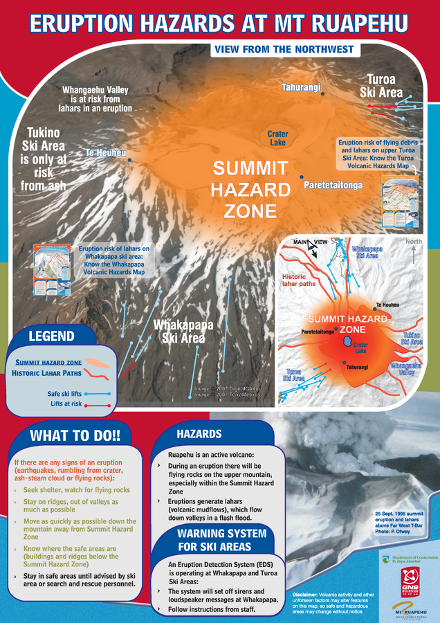
Eruption Hazards at Mt. Ruapehu
GNS Science (compiler). (2007). Eruption Hazards at Mt. Ruapehu. 8 October 2007.
Official, Sign or billboard
Eruption Hazards at Mt. Ruapehu
GNS Science (compiler). (2008). Eruption Hazards at Mt. Ruapehu.
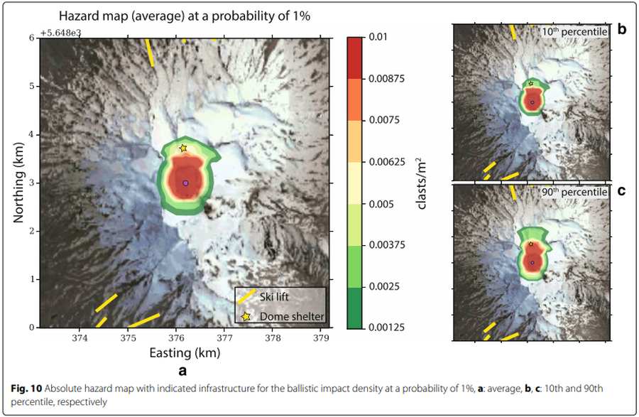
Figure in a journal article
Hazard map (average) at a probability of 1%
Figure 10 in: Strehlow, K., Sandri, L., Gottsmann, J. H., Kilgour, G., Rust, A. C., & Tonini, R. (2017). Phreatic eruptions at crater lakes: occurrence statistics and probabilistic hazard forecast. Journal of Applied Volcanology, 6(1), 4. https://doi.org/10.1186/s13617-016-0053-2
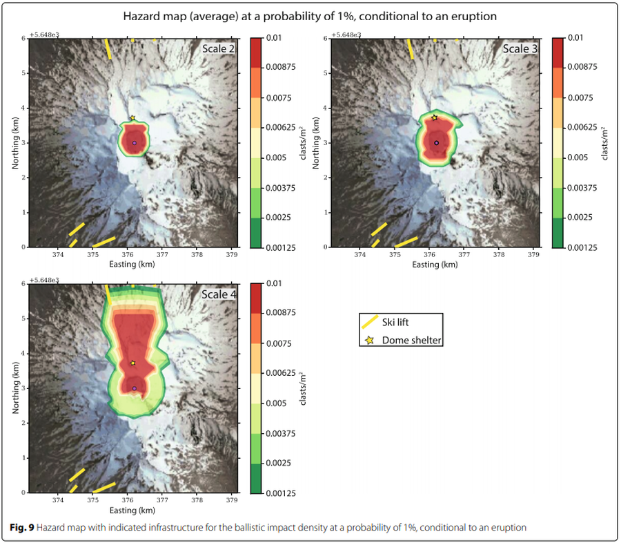
Figure in a journal article
Hazard map (average) at a probability of 1% conditional to an eruption
Figure 9 in: Strehlow, K., Sandri, L., Gottsmann, J. H., Kilgour, G., Rust, A. C., & Tonini, R. (2017). Phreatic eruptions at crater lakes: occurrence statistics and probabilistic hazard forecast. Journal of Applied Volcanology, 6(1), 4. https://doi.org/10.1186/s13617-016-0053-2

Official, Sign or billboard
Lahar Warning Whakapapa Village
Department of Conservation. Lahar Warning Whakapapa Village.

Official, Sign or billboard
Map of areas not recommended not to enter or camp - Ruapehu Volcanic Risk
Department of Conservation. (2020). Map of areas not recommended not to enter or camp - Ruapehu Volcanic Risk. September 2020 R183230.

Figure in a journal article
Principal lahar paths at Ruapehu volcano and source areas for the lahars.
Figure 7 in: Houghton, B.F., Latter, J.H., & Hackett, W.R. (1987). Volcanic hazard assessment for Ruapehu composite volcano, Taupo volcanic zone, New Zealand. Bulletin of volcanology, 49(6), p. 737-751. https://doi.org/10.1007/BF01079825

Figure in a journal article
Probability for areas to experience a ballistic impact density >0.01, conditional to an eruption
Figure 11 in: Strehlow, K., Sandri, L., Gottsmann, J. H., Kilgour, G., Rust, A. C., & Tonini, R. (2017). Phreatic eruptions at crater lakes: occurrence statistics and probabilistic hazard forecast. Journal of Applied Volcanology, 6(1), 4. https://doi.org/10.1186/s13617-016-0053-2