Advanced Search for Maps
Showing 1-3 of 3
Lewotolo (Lewotolok), Indonesia
Official, Map in an information statement
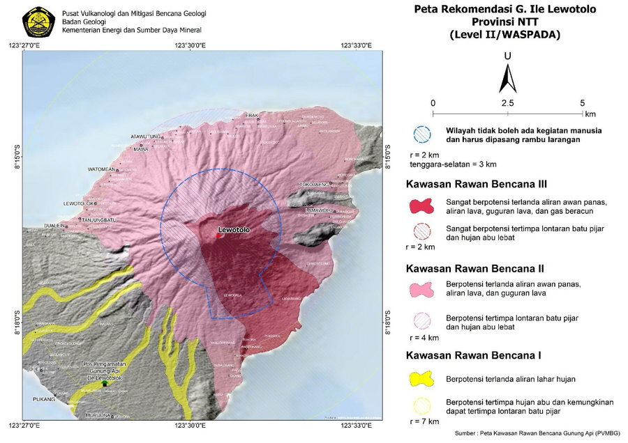
Peta Rekomendasi G. Ile Lewotolo Provinsi NTT (Level II/WASPADA)
(Recommended Map of G. Ile Lewotolo NTT Province (Level II/ALERT))
Pusat Vulanologi dan Mitigasi Bencana Geologi (PVMBG). (2024). Peta Rekomendasi G. Ile Lewotolo Provinsi NTT (Level II/WASPADA). Press Release PERLUASAN JARAK REKOMENDASI GUNUNGAPI ILI LEWOTOLOK 24 FEBRUARI 2024 PUKUL 17:00 WITA. https://vsi.esdm.go.id/press-release/press-release-perluasan-jarak-rekomendasi-gunungapi-ili-lewotolok-24-februari-2024-pukul-1700-wita
Lewotolo (Lewotolok), Indonesia
Official, Map in an information statement
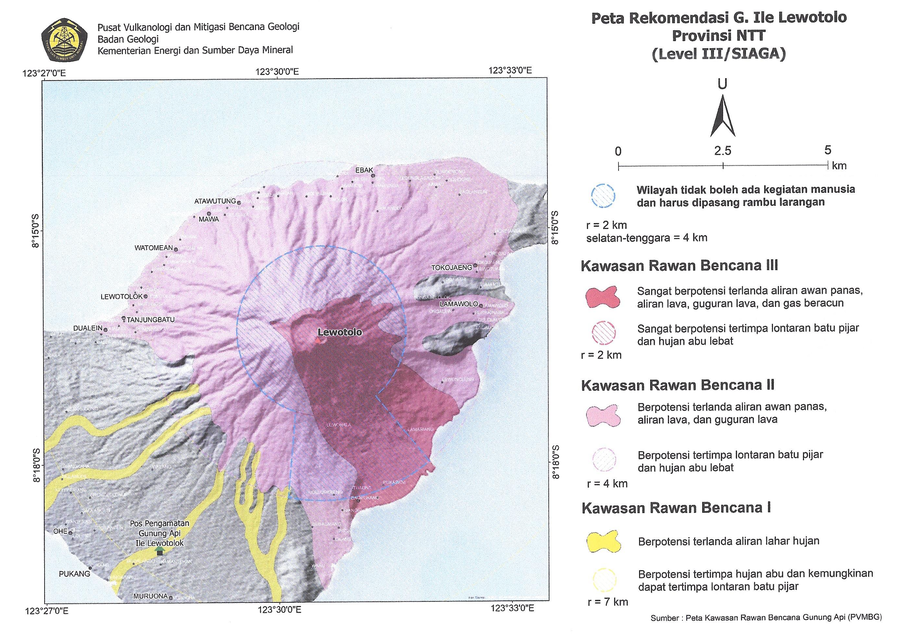
Peta Rekomendasi G. Ile Lewotolo Provinsi NTT (Level III/SIAGA)
(Recommended Map of G. Ile Lewotolo NTT Province (Level III/STANDBY))
Pusat Vulanologi dan Mitigasi Bencana Geologi (PVMBG). (2024). Peta Rekomendasi G. Ile Lewotolo Provinsi NTT (Level III/SIAGA). Penyampaian Peningkatan Tingkat Aktivitas G. Ili Lewotolok, Nusa Tenggara Timur dari Level I (Waspada) ke Level I (Siaga) tanggal 27 Februari 2024 Pukul 10:00 WITA. https://vsi.esdm.go.id/press-release/penyampaian-peningkatan-tingkat-aktivitas-g-ili-lewotolok-nusa-tenggara-timur-dari-level-i-waspada-ke-level-i-siaga-tanggal-27-februari-2024-pukul-1000-wita
Lewotolo (Lewotolok), Indonesia
Official, Map sheet or poster
Volcanic Hazard Map of Lewotolo Volcano, East Nusa Tenggara Province
Kartadinata, M.N., Mulyana, A.R., Nursalim, A., Rukada, T., & Ridwan, I. (2010). Volcanic Hazard Map of Lewotolo Volcano, East Nusa Tenggara Province. Center for Volcanology and Geological Hazard Mitigation (CVGHM).