
Advanced Search for Maps
Showing 1-10 of 10
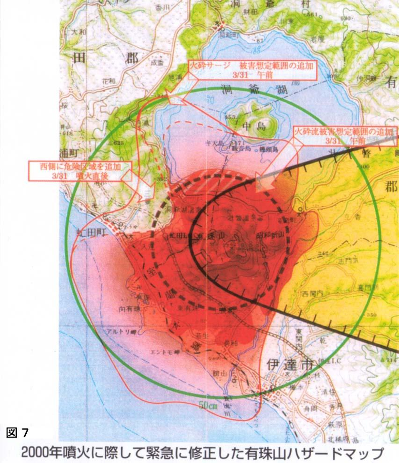
Official, Figure on website
Emergency hazard map of Mt. usu revised after the 2000 eruption
Figure 7 in: Nakao, M. (2005). Eruption of Mt Usu, March 31 st 2000, at Mt Usu in Hokkaido. In: Failure Knowledge Database, 100 Selected Cases. http://www.shippai.org/fkd/en/cfen/CA1000619.html. Reprinted from: The Hokkaido Shimbun Press. (2002) 2000-Nen Usu-Zan Funka (The 2000 Mt. Usu Eruption). The Hokkaido Shimbun Press.
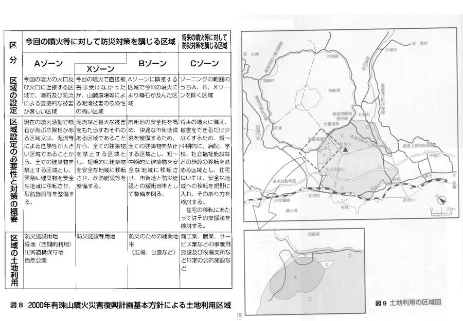
Official, Figure on website
Land use area map. Land use areas according to the basic policy of the 2000 Mt. Usu eruption disaster recovery plan.
Figure 8-9 in: Nakao, M. (2005). Eruption of Mt Usu, March 31 st 2000, at Mt Usu in Hokkaido. In: Failure Knowledge Database, 100 Selected Cases. http://www.shippai.org/fkd/en/cfen/CA1000619.html. Reprinted from: The Hokkaido Shimbun Press. (2002) 2000-Nen Usu-Zan Funka (The 2000 Mt. Usu Eruption). The Hokkaido Shimbun Press.
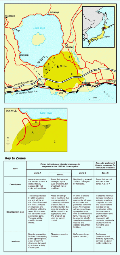
Figure in a journal article
Land use zoning map for areas around Mount Usu
Figure 3 in: Becker, J.S., Saunders, W.S.A., Robertson, C.M., Leonard, G.S., & Johnston, D.M. (2010). A synthesis of challenges and opportunities for reducing volcanic risk through land use planning in New Zealand. The Australasian Journal of Disaster and Trauma Studies, 2010-1. (Simplified from: Nakao 2005)
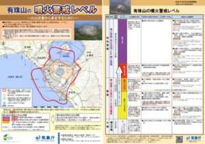
Official, Flyer, brochure, short fact-sheet, or handout
Mount Usu Volcanic Alert Levels
Japan Meteorological Agency. (2020). Mount Usu Volcanic Alert Levels. Volcano Monitoring and Warning Center, Volcano Division, Earthquake and Volcano Department.
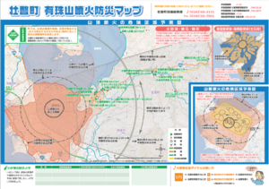
Official, Map sheet or poster
Sobetsu Usuzan Eruption Disaster Prevention Map
Sobetsu Town Office General Affairs Division. (2013). Sobetsu Usuzan Eruption Disaster Prevention Map
Official, Map sheet or poster
Usu Volcano Disaster Prevention Map
Hokkaido Disaster Prevention Committee. (2002). Volcanic Disaster Prevention Map of Mt. Usu. Date City, Toyako Town, Sobetsu City, and Toyoura Town.
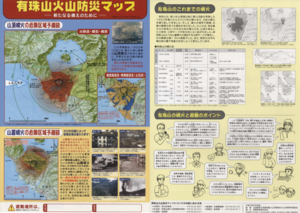
Official, Map in a booklet, long fact-sheet, or handbook
Usu Volcano Disaster Prevention Map
Hokkaido Disaster Prevention Committee. (2003). Usu Mountain Area Disaster Prevention Guidebook. Date City, Toyako Town, Sobetsu City, and Toyoura Town.
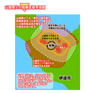
Official, Figure on website
Usu Volcano Disaster Prevention Map [Expected danger area of flank eruption]
Toyoura Town. (Year Unknown). Usu Volcano Disaster Prevention Map. https://www.town.toyoura.hokkaido.jp/hotnews/detail/00000340.html
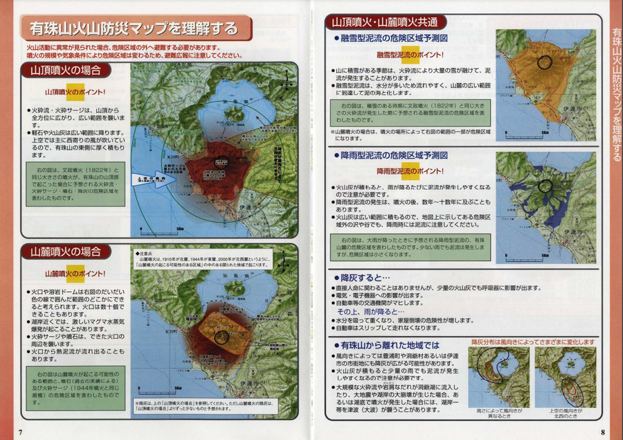
Official, Figure on website
Usu Volcano Disaster Prevention Map [Summit eruption: Pyroclastic flow, volcanic block, ash fall]
Toyoura Town. (Year Unknown). Usu Volcano Disaster Prevention Map. https://www.town.toyoura.hokkaido.jp/hotnews/detail/00000340.html
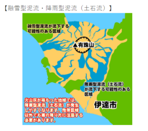
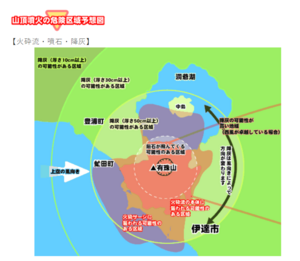
Official, Figure on website
Usu Volcano Disaster Prevention Map [Summit eruption: snow-melting type mudflow, rainfall-type mudflow]
Toyoura Town. (Year Unknown). Usu Volcano Disaster Prevention Map. https://www.town.toyoura.hokkaido.jp/hotnews/detail/00000340.html